Bridleway
4
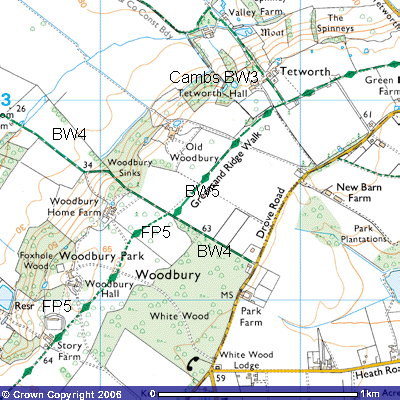
Distance: about 2,900m. Direction ESE – WNW
This
bridleway starts on west side of Drove Road, between Everton and Gamlingay
Cinques. Road, at the northeast corner of White Wood (TL 218522). It was one of
the routes the farmer of Park Farm on the eastern side of the road used to
cross the Woodbury estate to get to Tempsford and the Great North Road. When
the Great North Eastern Railway was built in 1850, it took you to Tempsford
Railway Station.
52
There is one of the Woodbury Estate’s 19th
century gatehouse cottages at the entrance to the drive to Woodbury Home Farm.
A plaque on the wall shows it was built by the Astell family sometime in the
1870s – the last number is missing.
Behind
them you can still see the ‘barns’, the local name for their washhouse and
storage sheds. The field gate is locked but a gap beside it lets you pass the
southern boundary of the garden of White Wood Corner cottage.
21 22
It
was here that Group Captain Fielden stayed whilst he was Station Commander of
Tempsford Airfield during World War Two. Local gossip has it that Italian
prisoners of war held in a camp in Woodbury Park, dug a tunnel from the cottage
down to the airfield. This is unlikely
but it is possible that his assistant drove him along the route in his car.
The route follows the edge of White Wood for about 500
metres along about a five-metre wide track with high bracken, nettles and
brambles growing in the hedgerows. A paddock can be seen behind the hedge to
the north where a row of new trees has been planted in recent years. Many
mature pines can be seen in the woods which date back several hundred years.
Just before a large oak tree there is a gap in the hedge (TL 214524) where you
can see the way marker signpost for the Greensand Ridge Walk that takes you
northeast along Bridleway 5 Tetworth. Through decades of disuse, the vegetation
in the hedgerows has grown so much that vehicles no longer use this track but
it is wide enough for a horse or pedestrian. Less than a 100 metres further on
you will see another kissing gate beside a few hundred-year old oak tree (TL
214524), giving you access to Footpath 5 southwest through Woodbury Park.
Continuing northwest, the track becomes concreted for about a 100 metres on the
top of the ridge and stops at a farm gate (TL 212535). Three upright railway
sleepers block vehicular access down the track to Woodbury Sinks. A mature
woodland of old oaks, beech and silver birch grows on the scarp slope of the
ridge. In late-April – early May you can glimpse from the path a stunning
bluebell display. Foxgloves and Spring Beauty also enjoy the dappled shade cast
by the Beech and Silver Birch and an avenue of Limes. Several paths lead into
these woods but it is private woodland.
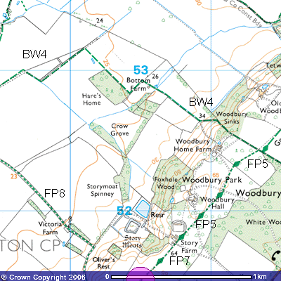 Once
you start to descend the hill, the track widens to about 10 metres as, over the
centuries, horses and cattle hooves and cartwheels have cut a wide swathe down
the hill. Be warned, it is very difficult to walk on in both wet and dry
weather, even with walking shoes or Wellington boots. As the track crosses the
spring line, horses hooves have churned up the clay leaving deep, often
water-filled holes, in which one can easily twist an ankle. It has been
suggested that fencing off a metre wide stretch alongside the ditch for
pedestrians will reduce the wear and tear on the track. 30 – 40 m. wide.
Once
you start to descend the hill, the track widens to about 10 metres as, over the
centuries, horses and cattle hooves and cartwheels have cut a wide swathe down
the hill. Be warned, it is very difficult to walk on in both wet and dry
weather, even with walking shoes or Wellington boots. As the track crosses the
spring line, horses hooves have churned up the clay leaving deep, often
water-filled holes, in which one can easily twist an ankle. It has been
suggested that fencing off a metre wide stretch alongside the ditch for
pedestrians will reduce the wear and tear on the track. 30 – 40 m. wide.
21 20
The track veers to the south once you get
out of the woods and dry ground is only reached close to the concrete road
leading back up the hill to Old Woodbury (TL 209526). This track then turns
west and takes you along the edge of a field with a deep drainage ditch on its
northern side and a field of hawthorn and rowan trees.
Judy Knight, the Bedfordshire naturalist,
commented that on Bridleway 4 . Skylarks continue to sing
overhead. At your feet the delicate yellow flowers of the Field Pansy grow on
the rough soil. Another bird of the agricultural landscape is the Yellowhammer;
in summer the males are resplendent in bright yellow plumage and tirelessly
deliver their song which begins with a rattle and ends with a wheeze – said to
resemble “A little bit of bread and no cheeeese”. The Whitethroats here can barely compete!
You
pass alongside a new hawthorn hedge to the north, behind which is a new
plantation of mixed woodland. As you approach the Roman Road you pass a raised
petrol tank for the farm machinery.
A
new plantation of mixed woodland has been planted alongside the track. The
track looks as if it follows the line of the runway past a huge pile of
concrete rubble, broken sections of the runway, but it veers slightly west. You
now join the Roman Road that runs south – north through WW2 Tempsford Airfield.