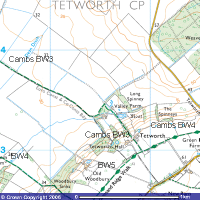
Cambs. Bridleway
No. 3
Distance: c.2,800m Direction: ESE - WNW
52
This bridleway follows the County Boundary between
Bedfordshire and Huntingdonshire and was one of the ancient routes between
Gamlingay and Tempsford. It forms the northern part of the Skylark Ride, East
Bedfordshire’s 36 km circular horse ride from Sutton, through Wrestlingworth,
across Biggleswade Common, up through Sandy Warren to the Roman Road. So, if
you don’t meet up with any horse riders, you will see plenty of evidence of
horses’ hooves in the mud along the way.
It
starts about 600 metres from the end of the Greensand Ridge Path, just in front
of Tetworth Hall (TL 219529) and follows the access road from the Gamlingay
Road to the Hall. Here it turns northwest just after the small red-bricked 18th
century Dells Cottage. The first few hundred metres are a metalled track which
takes you between Tetworth Hall to the southwest and some wood shingle clad
estate cottages to the north. Depending
on the time of year you should notice several mature cherry trees beside the
road. Once past the cottages the road turns into the back of the Hall.
21 22
53
You can see black corrugated iron barns, black
Bedfordshire weatherboard stable blocks and a woodshed. Bridleway 3 continues
along the now concreted track and descends a 1:17 slope down the ridge. Some
tipping of bricks and sand is an attempt to raise the bank alongside the ditch.
This drains into what is thought to be a medieval fishpond (TL 217534), in the
woods at the bottom of the hill. This is part of a significant moated site of
the half-timbered Valley Farm (TL 216535). It is fed by a number of springs
emerging along the junction of the impermeable Oxford Clay. Dickie Dodds, the
Essex bowler who lived there for years, told that there used to be a huge stone
circle in prehistoric times. The house was built around 1650 on the site of a
deserted medieval village in part of Canon's Manor, The nearby medieval
cottages burnt down, whether during some conflict or accident is unknown. There
were three groves of oak trees behind the house and the present oaks are their
descendants. (Author’s conversation with Dickie Dodds, St. Neots) Drainage work
for the construction of Tempsford Airfield during World War Two and in the
years following have lowered the water table so the moat no longer is fed with
spring water. The woodlands behind the
house are called the Long Spinney, protecting the house from the northerly
winds.
Maybe
you will see a herd of cattle grazing in the field of pasture opposite Valley
Farm. Rather than following the farm track to the black, corrugated iron farm
buildings in the trees, the bridleway continues across the field to the
northwest and then does a right-angle turn, almost due south. You pass a small
pine plantation and meet up with the track on the other side. It then turns
northwest again and follows the northern side of the hedge along the
Cambridgeshire – Bedfordshire county boundary for just over two kilometres,
over Dean Ditch (TL 207537), past Gilrags Coppice (TL 203539) and over two
footbridges to cross the Roman Road (TL 198542). There used to be another 19th
century farm called The Elms at the northwest of this junction which was
dismantled during the construction of the secret airfield to give the
impression that the area was deserted.
54 20 21 55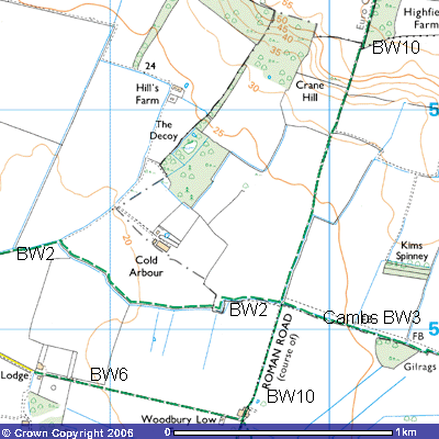
The Roman Road south takes you along the Everton and
Tempsford parish boundary past Woodbury Low Farm and across Tempsford Airfield
towards Sandy. This forms the western part of the Skylark Ride. The route north
takes you up Bridleway 1 past Highfield Spinney to meet Drewells Lane on the
road to St Neots. Bridleway 3 continues for about 300 metres along the northern
bank of one of the drainage ditches towards Cold Arbour Farm. At the end of the
hedge it opens into a U-shaped meadow and you cross it join Bridleway 2
(Tempsford) at the southwest corner of the field (TL 185542).
This
follows a hawthorn hedge on the northern side of a drainage ditch for about 800
metres until it meets the minor road (TL 177544).
Following
this road west, Bridleway 2 ends at Station Farm, 300 metres northeast of
Tempsford level crossing (TL173544).