BOAT 7
Distance: 1,100m. Direction: N – S
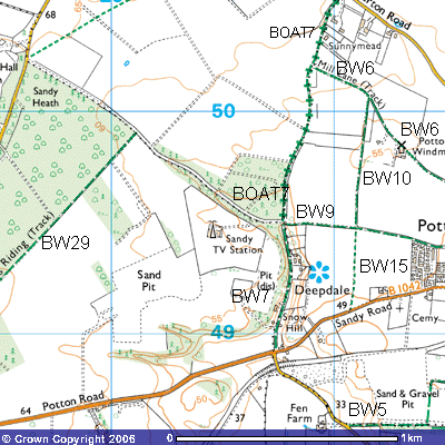 This
BOAT (Bridleway Open to All Traffic) was the route along the Everton and Potton
parish boundary between the crossroads at Deepdale and Everton Road. When it
was last used by vehicles is unknown as part of the route is so overgrown and
soil erosion of the sand has made it impassable to even four-wheeled drives.
Motorbikes might well be able to navigate obstructions, albeit if they do so in
first gear. Horse-riders will fare better but they may need to duck
occasionally to avoid overhanging branches. It forms part of the Skylark Ride,
East Bedfordshire’s 36 km circular horse ride from Sutton, through
Wrestlingworth, across Biggleswade Common, up through Sandy Warren, the Roman
Road and then along the county boundary to Gamlingay Cinques and then back
along Drove Road and through Everton Heath to here. So, if you don’t meet up
with any horse riders, you will see plenty of evidence of horses’ hooves in the
mud along the way.
This
BOAT (Bridleway Open to All Traffic) was the route along the Everton and Potton
parish boundary between the crossroads at Deepdale and Everton Road. When it
was last used by vehicles is unknown as part of the route is so overgrown and
soil erosion of the sand has made it impassable to even four-wheeled drives.
Motorbikes might well be able to navigate obstructions, albeit if they do so in
first gear. Horse-riders will fare better but they may need to duck
occasionally to avoid overhanging branches. It forms part of the Skylark Ride,
East Bedfordshire’s 36 km circular horse ride from Sutton, through
Wrestlingworth, across Biggleswade Common, up through Sandy Warren, the Roman
Road and then along the county boundary to Gamlingay Cinques and then back
along Drove Road and through Everton Heath to here. So, if you don’t meet up
with any horse riders, you will see plenty of evidence of horses’ hooves in the
mud along the way.
21 20 20
It starts at the junction of Bridleway 9 (Potton),
the Old Bedford Road, with Bridleway 7 (TL 208496). The metalled road past the
Deepdale Water Gardens turns north through the woods towards the entrance to
the Sandy TV Transmitter.
BOAT
7 continues through the woods to the north for about 300 metres, along a sandy
path at the bottom of a shallow valley, thought to have been washed out by
glacial melt-water after the last ice-age over 10,000 years ago. In places,
fallen down trees have meant the best route is around it so paths have been
generated a few metres further up the bank to the west.
It
emerges from the woods (TL 208498) giving views west towards Oak Farm and
northwest over wheat fields to Everton village on the horizon. It follows the
western side of a mature hawthorn hedge for about 200 metres when you meet a crossroads.
The farm track to the south leads into Windmill Field and that to the north
follows field boundaries north for about 1,500 metres to Sandy Road, Everton.
About 300 metres further on you meet one end of Bridleway 6 (Potton, TL 209502)
which takes you southeast for about 1,000 metres down Mill Lane past the
disused Potton Windmill into Potton. Continuing north on what is now called
Mill Lane, you pass Sunnymead and ** Lodge. smallholdings on the eastern side
of the track. The former is 59 metres above sea level. Behind these properties
you will see a number of horse stables and paddocks. A few hundred metres
further on the bridleway meets Everton Road at the entrance to Ashmore Farm (TL
210505) where the parish boundary turns northwest towards Everton.