Bridleway 14 (East Hatley)
Direction: NNE – SSW and
NW - SE Distance:
c. 4.2 kms. Back to map
![]()
![]()
![]()
![]()
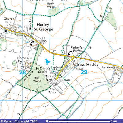
![]() Bridleway 14 starts opposite the Post Office on Hatley Road (TL
283509) at about 75 metres above sea
level. The first 700 metres are part of Buff Lane, an ancient track that runs
down the valley towards the deserted medieval village of Pincote. It is follows
a tarmac road south-southwest past some bungalows to the west and a stretch of
mixed woodland to the east. There are paddocks and stable blocks to the west
belonging to Home Farm (TL 281505). There is evidence of the medieval open
field system in the fields to the west.
Bridleway 14 starts opposite the Post Office on Hatley Road (TL
283509) at about 75 metres above sea
level. The first 700 metres are part of Buff Lane, an ancient track that runs
down the valley towards the deserted medieval village of Pincote. It is follows
a tarmac road south-southwest past some bungalows to the west and a stretch of
mixed woodland to the east. There are paddocks and stable blocks to the west
belonging to Home Farm (TL 281505). There is evidence of the medieval open
field system in the fields to the west. ![]() According to the Royal Historic Monuments Commission
According to the Royal Historic Monuments Commission
Around N.G. TL 276507 ridge and furrow running N.E. and S.W. is bounded by a winding hollow-way 40 ft. wide, 1 ft. to 3 ft. deep and 25 ft. across the bottom, perhaps an old route to Tadlow. To the E. of this are three small blocks of ridge and furrow running N. to S. with an access way, 30 ft. wide and 9 ins. Deep, running E. from the main hollow-way for 80 yds. between the two blocks further N. Traces on air photographs complement these remains and much of the former open-field pattern can be seen, with field boundaries fitting curving furlongs. The parish was probably enclosed by the 17th century. (Ref: tithe map 1839 (T.R.C.); air photographs: 1060/UK/ 1635/1465-8; CPE/UK/2024/3020, 3060-3; RCHM, Hatley, p. 151)
![]()
![]()
![]()
![]()
![]()
![]() Opposite
Home Farm is Buff Wood, private woodland which is a Site of Special Scientific
Interest (SSSI). According to the
Victoria County History of West Cambridgeshire
Opposite
Home Farm is Buff Wood, private woodland which is a Site of Special Scientific
Interest (SSSI). According to the
Victoria County History of West Cambridgeshire
From
the 17th century there were 40 a. of wood just west of the village
site, called in 1683 Lordship, Nobles, and Rigsbys woods (Downing Coll, Mun. V
1a, settlement 1683), by 1750 Hatley wood (Downing College maps, 1750); V IE,
val.1801), and by 1742 Buff wood (C.U.L., E.D.R., G, tithe award 1842). Ashes
and elms were sold from it in the late 19th century (e.g. C.R.O.,
296/SP 104, 133). Those 40 acres of wood were sold in 1947 to Cambridge
University for use for botanical studies (Cambs. Ind. Press, 1st
Dec. 1961).
(V.C.H.
Cambs. ii. p.43)
In the southeast corner
of the wood is a moated site, the site of the old rectory of East Hatley.
Details can be found in the account of Bridleway
15. At the end of the wood (TL 279503) a farm track continues southwest
down a valley towards Pincote Barn. However, Bridleway 14 turns east-southeast
to follow the south side of Buff Wood for about 400 metres towards a farm
building.
Behind the barn it meets
Bridleway 15, a farm track which takes
you northeast back into East Hatley past The Palace and Manor Farm or southwest
down the ridge to New England Farm and Tadlow.
![]()
![]()
![]()
![]()
![]()
![]()
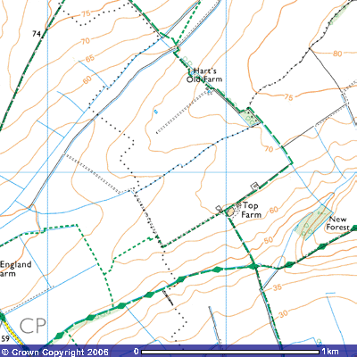
![]() Bridleway 14 continues southeast down the gentle slope of the valley
for about 500 metres where it crosses a footbridge over a drainage ditch (TL
287498) and, after a further 100 m., meets Footpath 16 at the footbridge over
the stream (TL 287496). After a ‘dog leg’, a few bends in the path, it
continues up the slope for about 300 m. to pass Hart’s Old Farm. It continues
southeast for about 300 metres across the flat top of the ridge, about 70
metres above sea level, and goes round the northern side of a copse (TL
292493). After a further 300 metres it begins to descend the slope and turns
southwest at the corner of the field (TL294490) and continues along the south
side of the hedge for 400 metres west-southwest towards Top Farm (TL 290488).
It continues west-southwest as Footpath 22 but Bridleway 14 turns
south-southeast and drops down a fairly steep slope to cross Bridleway 13, the
track that takes you east past the deserted medieval village of Clopton or west
towards Wrestlingworth. Bridleway 14 continues down the valley for a further
500 metres to meet the Tadlow Road opposite Croydon Farm (TL294478), 27 metres
above sea level.
Bridleway 14 continues southeast down the gentle slope of the valley
for about 500 metres where it crosses a footbridge over a drainage ditch (TL
287498) and, after a further 100 m., meets Footpath 16 at the footbridge over
the stream (TL 287496). After a ‘dog leg’, a few bends in the path, it
continues up the slope for about 300 m. to pass Hart’s Old Farm. It continues
southeast for about 300 metres across the flat top of the ridge, about 70
metres above sea level, and goes round the northern side of a copse (TL
292493). After a further 300 metres it begins to descend the slope and turns
southwest at the corner of the field (TL294490) and continues along the south
side of the hedge for 400 metres west-southwest towards Top Farm (TL 290488).
It continues west-southwest as Footpath 22 but Bridleway 14 turns
south-southeast and drops down a fairly steep slope to cross Bridleway 13, the
track that takes you east past the deserted medieval village of Clopton or west
towards Wrestlingworth. Bridleway 14 continues down the valley for a further
500 metres to meet the Tadlow Road opposite Croydon Farm (TL294478), 27 metres
above sea level.