Bridleway
2 (Tempsford) and Bridleway 3 (Cambridgeshire)
Distance: 1600 metres Direction: E – W
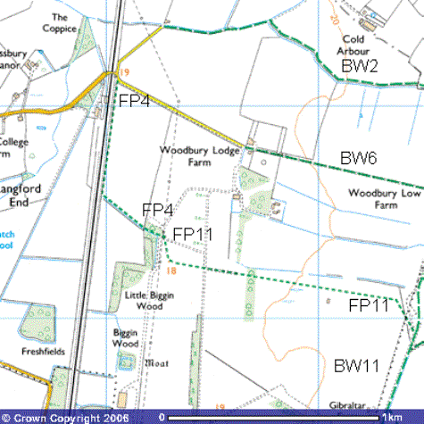
This Bridleway starts about 400 metres
northeast of Tempsford level crossing (TL 180542). There are no car parking
places east of the railway line so you need to find a safe place in Tempsford.
To reach the bridleway, follow the tarmac road north alongside the railway line
for about 100 metres. It begins just after you pass under the electricity
transmission line at the 19th century Station Farm (TL 183544) and
follows the road northeast alongside a field drain.
The mature hedge has a variety of trees
including oak, beech, sycamore, rowan, elder, hawthorn and dog rose. It is
particularly spectacular in late-April and early May when it is covered in
blossom and the smell of pollen fills the air.
Yellowhammers,
Willow Warblers, Whitethroats thrive in these hedgerows. After
about 600 metres, the bridleway leaves the road (TL 188544) and follows a
mature hawthorn hedge east-southeast alongside the northern side of the field
drain for about a kilometre.
This was one of numerous drainage ditches
dug in preparation for the construction of Tempsford Airfield, to lower the
water table of this previously flat, clay land. The drain flows west towards
the River Ivel north of Tempsford. John Button, a former farm manager on the
Woodbury estate, recalled finding brick foundations for one of the concrete
runways up to nine feet (3.15 m) thick. They had been brought in from the
bombed out cities of Peterborough and London.
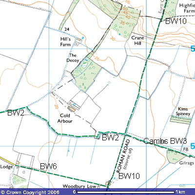
You can see Cold Arbour Farm to the north (TL
193544). Some historians think that the word “arbour” was a resting place for travellers using the Roman
road. Others think it was the deserted rooms or ruins of a Roman villa that
provided cold shelter for travellers
using this bridleway. High quality red Samian ware, bones and coins dating from between 161 AD to 378 AD
have been found in the vicinity.
 The
bridleway follows the hedge eastwards along the field boundary until it passes
through a gap in the hedge and crosses an old stone bridge into a grassy meadow
(TL 185541). Cowslips can be spotted in early spring. Nightingales can be heard singing from bushes on
early summer evenings and skylarks overhead. The Bridleway now
follows the boundary between Bedfordshire and Cambridgeshire, or more
correctly, the southwest corner of Huntingdonshire and becomes Bridleway 3.
There are attractive views northwest to Alington Hill, the extreme western edge
of the Greensand Ridge in this area. Looking eastwards you can see Boys Wood,
Sir John’s Wood on the crest of the ridge. Highlands Farm can just be made out
on the top of the hill and Stone Hill Farm just below it. Further east you can
see Weaveley Wood, just north of the white-washed rear walls of Tetworth Hall.
The red-bricked buildings of Old Woodbury and Woodbury Home Farm further south
can be spotted in the woods further southeast towards Everton.
The
bridleway crosses the corner of the field for about 100 metres and then turns
east, following the same field drain for about 350 metres until it crosses the
Roman Road (TL 188542). Reed Buntings
and Sedge Warbler can be heard singing bushes alongside the drainage ditch. Just
before the hedge along the eastern boundary of the field, a new wooden bridge
has been built across the field drain. It is not signposted but, crossing it,
it becomes Bridleway 10 which takes you south across Tempsford Airfield, The
wooden signpost is a little further east. Bridleway 1 (Cambridgeshire) takes
you north up the Roman Road up Crane Hill towards Highfield Spinney and
Abbotsley Golf Club. Bridleway 3 continues straight ahead to follow the county
boundary east-southeast for about 3,000 metres past Tetworth Hall towards
Gamlingay.