Bridleway 2 Hatley St George
Direction: roughly NW – SE;
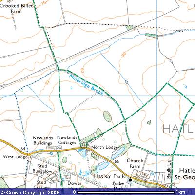
Distance c1000m.
![]()
![]()
![]()
![]()
![]()
![]() Bridleway 2 starts close to the boundary
between the parishes of Hatley St George, Little Gransden and Gamlingay at the
bridge over Millbridge Brook (270523) at 55 m. To the north you can see a long
embankment stretching ENE. Until the Beeching reforms of the railways in 1963
it was, the route of the Cambridge to Oxford railway line. The flat field on
the northern side of the brook was known in early 17th century as Broade
leae and was used as a gallop by the racehorses on Major Astor’s stud farm
in Hatley Park. Thomas Langdon’s 1601 map drawn up for Merton College, Oxford
marked the field to the east Hatley Fielde.
Bridleway 2 starts close to the boundary
between the parishes of Hatley St George, Little Gransden and Gamlingay at the
bridge over Millbridge Brook (270523) at 55 m. To the north you can see a long
embankment stretching ENE. Until the Beeching reforms of the railways in 1963
it was, the route of the Cambridge to Oxford railway line. The flat field on
the northern side of the brook was known in early 17th century as Broade
leae and was used as a gallop by the racehorses on Major Astor’s stud farm
in Hatley Park. Thomas Langdon’s 1601 map drawn up for Merton College, Oxford
marked the field to the east Hatley Fielde.
On the north bank of Millbridge Brook was a
medieval brick works, utilising the clay and available water supply. A
supplement to the map included a ‘brick kyll upon ye Queen’s Land’’. A
scatter of ‘briquetage’ of uncertain date has been found in the area (TL
269521). In 1839 some Roman coins were found in the field to the south. As the
nearest Roman settlements were in Everton and Sandy, they may have been dropped
by travellers or hidden as a hoard. Bridleway 2 follows the north-eastern side
of Millbridge Brook south-east up a gentle slope for about a kilometre until it
meets the junction of Bridleway 3
and Footpath 7 (277517). Bridleway 7
continues southeast to meet the Hatley Road. Bridleway 3 takes you southwest to
meet the Hatley Road opposite North Lodge.