Bridleway 5 (The
Greensand Ridge Walk)
Direction:
NNE – SSW Distance:
![]()
![]()
 (Want to read it south to north?)
![]()
![]()
![]()
![]()
![]()
![]()
![]() The Greensand Ridge Walk
is a popular route which passes through the parishes of Everton cum Tetworth
and Sandy and is made up of Bridleway 5, Footpath 5, Bridleway 2 (Everton),
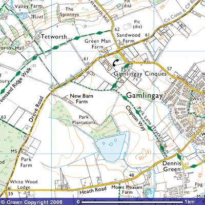
Footpath 7, Footpath 2, Bridleway 3 and Bridleway 27. Bridleway 5 starts (or finishes) at a small lay-by on the west
side of the road from Gamlingay Cinques to St Neots on the top of Tetworth Hill
(TL 225522). There is a 62 metre spot height marked on the map showing that you
are on the crown of the hill. There is enough room for you to park your car but
as there is a field gate to a cow pasture it would be best to arrange to be
dropped (or picked up) there. However, there is a small car park (TL
227528) in the centre of Gamlingay Cinques, the small hamlet by the crossroads.
Boots are recommended, as the path can be uneven and muddy in places. A pair of
binoculars will be useful too for there are a range of interesting sights to
observe trees, birds and buildings. Maybe you will spot a muntjac or two, the symbol
seen on the Greensand Ridge Walk signposts. This small deer was introduced into
country parks in southern and eastern England in 1900 and are now quite common
in Bedfordshire following their escape from the deer park at Woburn Abbey. Many
have been spotted in this area in recent years.
The Greensand Ridge Walk
is a popular route which passes through the parishes of Everton cum Tetworth
and Sandy and is made up of Bridleway 5, Footpath 5, Bridleway 2 (Everton),
Footpath 7, Footpath 2, Bridleway 3 and Bridleway 27. Bridleway 5 starts (or finishes) at a small lay-by on the west
side of the road from Gamlingay Cinques to St Neots on the top of Tetworth Hill
(TL 225522). There is a 62 metre spot height marked on the map showing that you
are on the crown of the hill. There is enough room for you to park your car but
as there is a field gate to a cow pasture it would be best to arrange to be
dropped (or picked up) there. However, there is a small car park (TL
227528) in the centre of Gamlingay Cinques, the small hamlet by the crossroads.
Boots are recommended, as the path can be uneven and muddy in places. A pair of
binoculars will be useful too for there are a range of interesting sights to
observe trees, birds and buildings. Maybe you will spot a muntjac or two, the symbol
seen on the Greensand Ridge Walk signposts. This small deer was introduced into
country parks in southern and eastern England in 1900 and are now quite common
in Bedfordshire following their escape from the deer park at Woburn Abbey. Many
have been spotted in this area in recent years.
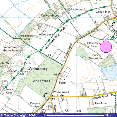
After going through
the field gate you follow an uneven footpath past a 1.5 metre high tree stump
of a diseased elm, southwestwards alongside the fence. It was one of numerous
elms cut down in the 1970s following an outbreak of Dutch Elm disease. Horses’
hooves and burrowing rabbits make the route slightly awkward, especially in wet
weather. Depending upon the time of year there might be a herd of cattle. They
can be quite off-putting when they follow you closely. The route is close to
but not actually on the edge of the Greensand Ridge. It is a few hundred metres
away to the northwest on private property behind Tetworth Hall. You can get
glimpses behind you to the north over the rolling Cambridgeshire countryside
and westwards across the Ivel valley. There used to be five sand pits dug into
this part of Gamlingay Great Heath. One can be seen just before the field
boundary. Nowadays, it forms part of an obstacle course for horse-riders, Many
of the fences along the first part of the path have jumps over them.
To the south you can
see green barns and red-bricked buildings of Green Man Farm (TL 225530) in
Gamlingay Cinques (sometimes spelt Sinks). During the 19th century it was very
common for farmers to brew their own beer and provide it free to their
agricultural labourers, with extra quantities at harvest time. This explains
why the farm was once used as a public house. Its connection with the ancient
stories of the green man is not certain. He is a pre-Christian symbol found
carved into the stone and wood of pagan temples and graves and used in medieval
churches and cathedrals across an area stretching from Ireland in the west to
Russia in the east. During Victorian times it was an architectural motif.
Although it is thought of an ancient Celtic symbol, its origins and original
meaning are shrouded in mystery. Aerial photographs of the ridge show evidence
of prehistoric settlement with a number of hut circles. The ridge top was used
as a trackway as the lighter sandy soils supported less trees than the poorly
drained valley bottoms so visibility was greater.
There have been a variety
of spellings for Tetworth. They include the 12th century Tethewurda
and the 13th century Tetteworth and Tettesworthe. It is claimed to
have derived from the Old English Tettan-wor, meaning “Tetta's enclosure or
farm.” Who Tetta was is not known and it is uncertain whether he, if it was a
he, lived on the site of Green Man Farm, Tetworth Hall or the moated Valley
Farm at the bottom of the ridge.
After about 400 metres
through two fields of pasture you pass through a field gate onto a single-track
road leading to Tetworth Hall. At the corner you pass Holly Cottage (TL
222532), an attractive tiled white brick late-18th century estate
cottage with an ornate chimney and porch. As you follow the farm track you can
spot numerous beehives in two small plantations by the roadside. A few hundred
metres down the tree-lined drive, you pass Dell’s Cottage (TL 219529), another
small, late 17th or early 18th century timber-framed
estate cottage with a thatched roof and well-kept garden created in another
disused sand pit. Its chimney breast occupies about half the width of the gable
end. The road then turns northwest towards Tetworth Hall (TL 219530) down the ridge
past the medieval moated house of Valley Farm towards the Roman Road, Cold
Arbour Farm and Tempsford. This was part of the ancient trackway from Gamlingay
to Bedford, crossing the Great North Road and River Ivel at Tempsford. The
Greensand Ridge Walk, however, continues as Bridleway 5, through a small iron
gate into Tetworth Park.
Tetworth Hall was one of a
number of large properties built during the first half of the 18th
century on the top of the ridge — the others being Everton House, Woodbury Hall
and Hasells Hall in this area. Further west there were Ickwell Bury, Wrest
Park, Ampthill Park and Woburn Abbey. Tetworth Hall is a red brick, two-storey
Queen Anne mansion with a prospect over the lower Ivel valley to the northwest.
Local carstone has been used for dressing. This is a type of sandstone from the
quarries along the face of the Greensand Ridge near Sandy. The house has
basements, attics and an unusual tiled and hipped roof. Scratched on two bricks
immediately to the west of the back door are the initials and date ‘J P Esqr
1710’ and ‘T R 1710’. The house was built that year for John Pedley, the MP for
Huntingdonshire between 1706 – 8. The Pedley family had been landowners here
since 1653. James Pedley Junior of Tetworth died in 1714 and William Astell,
one of the directors of the South Sea Company of London, bought the southern
part of the estate. The South Sea Bubble burst in 1720 following financial
scandals. He and his descendants made their fortune from importing tea and
other products from India and the Far East.
James Pedley’s heir died
in 1722, also without a male heir. As a result the Pedley family line in
Tetworth died out in 1726. It then was owned by Edward Harley, the 2nd Earl of
Oxford, a collector and patron of letters and in 1740 it was owned by Philip
Yorke, the 1st Earl of Hardwicke and Lord Chancellor. Stanhope Pedley, one of
James’ relatives, acquired the estate in 1759 and kept it until he died in
1802. His wife, Mary owned it until her death in 1823. The coat of arms over
the front door is of Pedley impaling Foley, alluding to the marriage into the
Foley family of Essex. The estate is thought to have then descended from the
Pedleys to the Foleys. Henry Foley was the landowner in 1829. Charles Duncombe,
first Lord Feversham, subsequently purchased it from the owner of nearby
Waresley Park. One of his descendants rented it to one of the members of the
Orlebar family, Bedfordshire merchants thought to be from Hinwick Hall.
Augustus Orlebar was born in
Willington Vicarage, Bedfordshire, on April 28th 1860. He studied at
Eton and Worcester College, Oxford where he got a 1st class degree
in Classics. He won the Varsity half-mile and rowed for the college. He became
a VI Form tutor at Radley and Wellington Colleges between 1884 and 1891,
travelled a lot but settled at Tetworth Hall after he married Hester Mary
Knowles in 1895. He farmed 35 acres and was very sporty, engaging in
motorcycling, shooting and amateur photography. He became the chairman of the Education
Committee, a member of Caxton Rural District Council and Board of Guardians, a
JP and was president of the Gamlingay Conservative Association. He was
churchwarden of St Mary’s Church, Gamlingay from 1912 until his death in 1918.
He left a son and three daughters. Augustus Orlebar was leader of the RAF team
that won the Schneider air trophy for Britain in 1929. He became an Air-Vice-
Marshal. Dorothy, one of his three daughters, started the Guides in Gamlingay
in 1920 and worked with them and the Brownies. She was Brown Owl during the
Second World War and became Divisional Commissioner in the 1960s and eventually
Division President. She died in 1988 and a window in St Mary’s church in
Gamlingay is dedicated to her as well as a room at the Cambridgeshire Pack
Holiday House
In the late-1930s the Hall
was rented to Leonard Bower, but he had to move out when it was requisitioned
during the Second World War. What it
was used for is not known for certain. Certainly, troops were stationed in the
grounds who guarded Italian and German prisoners-of-war. Some outbuildings
still have their graffiti on the wall.
Whether there was a direct link with the secret operation going on down
the hill on Tempsford Airfield has not come to light. Local gossip had it that
there must have been spies living there as sometimes lights were seen in the
upstairs windows.
Peter Crossman of the
Watney Mann (?) brewing chain bought the whole estate in 1962. Lady Crossman
still lives there. The gardens are open to the public on two Sundays each
summer as part of the Open Gardens Scheme. Posters advertising it appear
several weeks beforehand. The wooded
slope has been landscaped with pools, ferns, and shady pathways amongst
rhododendrons, magnolias, azaleas and a wide variety of fine trees in a large
woodland garden and bog garden. The microclimate in the shaded woodland
provides perfect habitat for some beautiful plants – well worth a visit.
The hedges, fences and
walls that you see today would not have been in evidence a few centuries ago.
The grassland on the ridge top was largely used for sheep grazing. Woods,
bushes and scrub dominated the scarp slope and the valley floor below the
ridge. Wild flowers abounded. Locals could use the woods for collecting
windfalls, fruit, mushrooms, nuts and any game they might catch. Great tracts
of Everton and Sandy Heath were uncultivated and were mainly used by the landed
gentry for shooting duck, snipe, partridges and bitterns.
The agricultural land that
you see on the top of the hill today was originally infertile, sandy heath.
Over the millennia rainwater leached out the iron and other minerals in the
sandstone which crystallised as a hard pan along the water table. As the water
level fluctuated over the years a number of iron pans built up which led to
poor drainage. Several developments during the Agricultural and Industrial
Revolutions in the 18th and 19th century allowed this land to be brought under
cultivation. They were the deep, cast-iron ploughshare, the steam engine and
the coming of the railway.
A powerful steam plough
could break up the iron pan and allow the soil water to drain better. To improve the mineral content of the soil,
the railway companies provided free freight of horse manure collected from the
streets of London and other towns and cities. This allowed farmers to add cart
after cartload to their fields. From the second half of the 19th
century, artificial chemical fertilisers were used to bring much of this heath
land under cultivation.
Further south there are other disused sandpits. The first is
overgrown and you can spot rabbits in the undergrowth on summer evenings. Where
the road turns northwest towards Tetworth Hall you can see a field gate in the
fence in front (TL 218529). Another disused sand pit to the southeast forms one
of many obstacles you can see in a large paddock The huge, almost dead tree is
an about three-hundred-year old sweet chestnut. Its bole is about four metres
wide. Although the tree trunk has had most of its bark nibbled off by animals, one
branch is still prolific. The hollow remains of another, about two metres wide,
can be seen nearby. There was a fashion
for such trees during the 18th and early 19th century
following British military and naval expeditions in the Mediterranean against
France and Spain.
The path continues for
about 100 metres across the grass towards a field gate in the fence. Instead of
turning northwest towards the Hall, the path continues for a few metres along
the road and crosses a cattle grid. A fence post beside it has a sign saying
‘Warning – Electric Fence’ but there is no evidence of one. The road forms part
of the county boundary between Cambridgeshire into Bedfordshire. The Greensand
Ridge Walk continues as Bridleway 5 southwest alongside the fence over grassland.
There’s evidence of mole and rabbit activity near the copse. Continuing for a further few hundred metres
you will see Old Woodbury, a renovated medieval farmhouse on the ridge-top to
the west (TL 203528). This used to be known as Woodbury until the early 19th
century when Woodbury Hall was built. It then became known as Old Woodbury. It
was built by 1635 by Sir John Jacob of Bromley, Middlesex, and said to be “a very pretty gentleman-like house“. He
was a ‘Farmer of the Customs’ in that he collected the import and export duties
from national and international traders and kept a percentage for his service
before handing it over to the King. He benefited Gamlingay by paying for the
construction of the ten almshouses on the High Street. Old Woodbury is thought
to have been built on the site of the 11th century Tetworth manor house, owned
at one time by the Prior of the Knights of St John of Jerusalem. It was the
custom for Norman knights to go on the Crusade or a pilgrimage to the Holy Land
and, before they left, gave their estate to the church to be managed. The
Knights had a preceptory (major centre) at Shingay in Cambridgeshire. In about
1150, Henry de Constentin, his son Geoffrey and grandson Elias granted lands in
Tetworth to the Cistercian monastery of Sawtry, near Huntingdon.
An old hollow way about 13
metres wide and almost a metre deep runs northwest down the slope to a deserted
medieval settlement of three house platforms and two enclosures. Another hollow
way, about 2 – 3 metres wide and up to 2.5 metres deep in places runs southwest
through Woodbury Sinks. Over millennia, the constant tread of animals’ hooves
loosened the soil and the ruts left by cartwheels during wet weather created
deep ruts. These formed natural channels for rainwater to wash out the soil to
leave these sunken tracks.
During the reign of Queen
Elizabeth I, Edmund, Lord Sheffield, inherited the Woodbury estate including
Gamlingay Heath from the Delve family and lived at times in Gamlingay House, a
large half-timbered country house in Gamlingay Park. In 1591 it was sold to
John Machell, a wealthy London cloth merchant and Justice of the Peace, who
lived at Sutton House, Hackney. Machell's purchase of this extensive and
expensive estate of 1,800-acre Woodbury Manor stretched him financially. He
couldn't raise the money to pay for it. In his attempt to raise the capital he
had to mortgage Sutton House and another estate that he owned at Hinxton, near
Duxford, to Sir James Deane, an East India Company man and money lender. As he
was not able to repay the loan with its interest by the agreed time, Deane
deprived him of access to Woodbury and he had to go into hiding. However, it
was claimed by Deane that a party of Machell's followers, led by his second
wife, Ursula, and their son John, armed with swords and halberds, returned to
Woodbury. They entered the property from the rear and seized it from Deane's
men.
Deane took Machel to
court. In the Quarter Sessions there is an account of a fight in the fields of Woodbury
between the headstrong William Machell and others of his father's party and
some of Deane's supporters involving the use of pikestaffs and poles. One of
the group also had a rapier but he claimed not to have used it. Witnesses
corroborated Machel's claim that, in 1599, Deane, in the company of the
under-sheriff of Cambridgeshire and armed with a writ of liberate, seized the
manor house. He forcibly ejected Ursula and her servants who had taken refuge
in some of the upper rooms. Although the precise outcome of the case is not
known, Deane seems to have prevailed and Ursula had to find alternative
accommodation.
In 1606 Machel was
committed for six years to the King's Bench prison in Southwark, as a debtor.
After his release in 1612 he returned to Old Woodbury where he lived until his
eighties. Following his death in 1624 “worn
out with care and grief for his losses“,
his grandson, also called John Machell, sold the estate sometime
before 1640 to Sir John Jacob.
Gamlingay Park was the
adjoining estate to the east in which the ‘Full Moon Gate’ was found. It used
to be a brick letter ‘O’ about 6.5 metres high with a glass window inside. Dick
Turpin, the highwayman, is claimed to have jumped through it on Black Bess, his
horse, to escape those chasing him after a robbery. Some documents suggest it
was built as a folly in 1712 by Sir George Downing, one time resident of
Gamlingay House. A local story has it that his eccentricty included building a
brick wall making up the seven ;etters of his surname and only the O survived.
As Downing lived from 1624 – 1684 this theory has been discounted. Others
suggest that Sir John Jacob had the wall built to commemorate his centenary in the reign of Charles I, and
that it contained the number “100”. It was a local landmark until early in the
20th century when the upper arc eventually collapsed. Local people found it a
romantic spot on warm, moonlit evenings. A more recent explanation is that it
was a lunette – an over two-metre wide circular window at the end of an avenue of trees through
which the bright moonlit sky would appear on a dark evening as a huge full
moon. Like Gamlingay House, the only
evidence of it today is the pillars hidden in undergrowth in a hawthorn hedge.
Downing was a
Parliamentarian during the Civil War and acted as Oliver Cromwell’s
scout-master (chief spy) in Scotland from 1650 – 1657 for which he was paid
£365 a year as well as £300 as a teller of the exchequer. He
was then appointed resident at The Hague, to try to unite the Protestant European
powers, to mediate between Portugal and Holland and between Sweden and Denmark,
to defend the interests of the English traders against the Dutch, and to inform
the government concerning the movements of the exiled royalists. Despite his
background, Charles II rewarded him for his diplomatic skills with a knighthood in May
1660. He was also given land next to St James’ Park, London, subsequently named
Downing Street. During his time in office he amassed enormous wealth. He died
in Gamlingay House in 1684. Downing College, Cambridge, was named after his
grandson, George Downing (1684-1749), the
third baronet. For more details on the Downings read about Footpath 8.
Nathaniel Richmond, a landscape
gardener and contemporary of ‘Capability’ Brown, landscaped the grounds between
1760 and 1767. There was an informal park, a separate and distinct walled
garden and a serpentine belt of bushes and occasional clumps of shrubs. The
owner of Woodbury estate at that time was George Lane Parker (1724 – 1791), a
Colonel in George III’s army. It had been in his family’s possession since his
grandfather bought it in the late-17th century. Ralph Lane was a ‘Turkey Merchant’, not the
kind that fatten birds for the Christmas market, but a silk and textile trader
with Turkey and the Middle East. Richmond was working between 1764 – 68 on
William Pym’s Hasells Hall estate a few kilometres down the Greensand Ridge
towards Sandy. He would have been seen riding his horse along the same route as
the Greensand Ridge Walk.
You can see fenced-in
clumps of trees in the pasture and, about 250 metres further, a younger sweet
chestnut growing beside the field gate (TL 217528). Once through it, the path
crosses the road to Old Woodbury and continues southwest alongside the
north-western boundary of a barley field for about 300 metres. A small track to
the southeast leads to a smallholding but the Greensand Ridge Path continues
for a further 200 metres along the field boundary. Unusually, there are five
laburnum trees growing amongst broom, hawthorn and small oaks. Their hanging,
yellow flowers are quite dramatic in late spring. Beware of their seed pods as
the peas are said to be poisonous. Bridleway 5 ends by the signpost at the gap
in the hedge under a several hundred-year-old oak tree (TL 214524) where it
meets Bridleway 4. Following it west takes you
down the Greensand Ridge past Woodbury Sinks (Cinques), towards the Roman Road
and Woodbury Low Farm. The track to the east takes you past the northern
boundary of White Wood to Drove Road.
The Greensand Ridge Walk continues as Footpath 5 through Woodbury Park and into
Everton. Follow Bridleway 4 west for about 100 metres and you’ll see a kissing
gate underneath another ancient oak tree on the south side of the hedge.