Bridleway 6
Direction N – S, Distance
c.1150m.
![]()
![]()
![]()
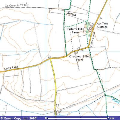 Bridleway
6 starts on the north side of Long Lane, just before Crooked Billet Farm. At
about 75 metres above sea level it is the highest point in Gamlingay parish
with commanding views over the surrounding countryside. It is a remnant of the
chalk downs, heavily eroded during previous ice ages and now covered in what is
called ‘glacial till’, clay, sand and boulders dumped when the last ice sheet
retreated northwards.
Bridleway
6 starts on the north side of Long Lane, just before Crooked Billet Farm. At
about 75 metres above sea level it is the highest point in Gamlingay parish
with commanding views over the surrounding countryside. It is a remnant of the
chalk downs, heavily eroded during previous ice ages and now covered in what is
called ‘glacial till’, clay, sand and boulders dumped when the last ice sheet
retreated northwards.
The first part of the bridleway takes you
north for about 500 m. to meet the parish boundary with Little Gransden
(263534). It was marked on Thomas Langdon’s 1601 map of Gamlingay as Procession
Waye. It showed the first field to the west as owned by Clare
Hall, Cambridge and farmed by Fr. Ratforde. The next was owned by Jo. Burgon
(possibly John Burgoyne, the Lord of Potton Manor) and farmed by Saltrye. These
fields to the west were part of East Field, one of three large open fields in
medieval times. An east-west track called
Corne Deane provided the peasants with access to their strips., suggesting
cereals being planted (263535). It continues to Fuller’s Hill Farm in the east
as Footpath 11 in Little Gransden.
Also marked on the map was Procession balke, an indication that
this was part of the traditional route taken by the parishioners when they were
‘beating the bounds’, the walk around the parish boundary. Balke is another
spelling of baulk, an unploughed strip of land between two furrows. Medieval
farmers took advantage of the gradient and ploughed up and down the hill. Today
this technique is frowned upon. Contour ploughing reduces the incidence of
rainwater washing the soil down the plough furrows. The booklet, Gamlingay’s Procession Waye,
can be found in the library.
To the east you can see the farm buildings
belonging to Fuller’s Hill Farm (267534). The word
"full" is from the Anglo-Saxon ‘fullian’, meaning to whiten and to
full is to press or scour woolen cloth in a mill. A
fuller then is a workman who fulls (cleans and thickens) freshly woven
cloth for a living. The well-drained soils on the chalk underlying Fuller’s
Hill was ideal grazing land
for sheep.
Continuing north for about 280m you cross
the Second World War airfield of Gransden Lodge to meet Waresley parish
boundary (263537). Footpath 11 takes you ENE for about 500 m. to the north of
the hangars. The airfield was built by 1942 as a satellite of RAF Tempsford and
for the first few years was the home of the RCAF (Royal Canadian Air Force) 405
(Vancouver) Squadron. In Michael Bowyer,’s
'ACTION STATIONS REVISITED' he states that it was
A typical wartime station, well dispersed and unusually set away from roads and amidst fields, it had the customary three runways,'036' of 2,000yards and two of 1,400yards. There were two'T2' hangars and a 'Bl', along with 36 hardstandings. Gransden was a smaller station than many, with accommodation for 86 officers, nearly 200 NCOs and over 800 airmen. Quarters were also available for nearly 300 WAAFS.
The Canadians and, at various times, the
Wireless Investigation Flight of 109 Squadron, 1418 Flight, Pathfinder
Navigational Unit, the Bomber Development Unit, 97 Squadron, 1517 Flight and 53
Squadron and 142 Squadron flew Wellingtons, Mosquitos, Stirlings, Halifaxes,
Lancaster bombers, Liberators and a Proctor airplane from here. More details can be found on the Gransden Lodge website.
There airfield is also the home of the Little Gransden show.
Details of which can be found in Damien
Burke’s account of the show. There is another airfield to the northeast,
the home of the Cambridge
University Gliding Club.
![]()
![]()
![]()
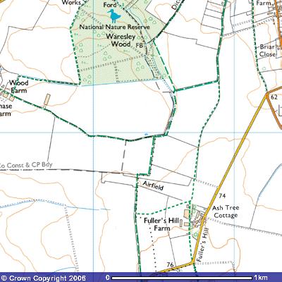 The footpath turns east for about 100 m
along southern edge of what was called Broade greene common on the 1601
map, before turning north again and following the Waresley-Little Gransden
parish boundary for about 300m, to the Cambridgeshire – Huntingdonshire County
Boundary (264539). The heavy water-logged clay soils here are the source of
Waresley Dean Brook, marked as ‘Issues’ on the 1:10,000 map, which drain roughly
NW through Waresley Wood. Bridleway 12 runs west along the Little Gransden -
Waresley parish boundary for about 200 metres until it meets the County
Constituency and CP Boundary. Bridleway 4 to the east follows the parish
boundary for about 100 metres before turning north to take you into the village
of Little Gransden.
The footpath turns east for about 100 m
along southern edge of what was called Broade greene common on the 1601
map, before turning north again and following the Waresley-Little Gransden
parish boundary for about 300m, to the Cambridgeshire – Huntingdonshire County
Boundary (264539). The heavy water-logged clay soils here are the source of
Waresley Dean Brook, marked as ‘Issues’ on the 1:10,000 map, which drain roughly
NW through Waresley Wood. Bridleway 12 runs west along the Little Gransden -
Waresley parish boundary for about 200 metres until it meets the County
Constituency and CP Boundary. Bridleway 4 to the east follows the parish
boundary for about 100 metres before turning north to take you into the village
of Little Gransden.