THE CONSERVATION WALKS, EVERTON
 In the late-1990s
Andrew and Ruth Pym, the owners of much of the land in Everton parish, used the
government’s initiatives - the Countryside Stewardship Scheme, the Countryside Access
Scheme and the Environmentally Sensitive Areas Scheme to very kindly provide
several new footpaths in the southwest of the village. With the economic
changes in 2008 several of these paths are no longer available, the land being
more profitable planted with cereals than being paid as “Setaside.” If the
situation changes they may be “re-opened” so the following description might
still be of some use/interest.
In the late-1990s
Andrew and Ruth Pym, the owners of much of the land in Everton parish, used the
government’s initiatives - the Countryside Stewardship Scheme, the Countryside Access
Scheme and the Environmentally Sensitive Areas Scheme to very kindly provide
several new footpaths in the southwest of the village. With the economic
changes in 2008 several of these paths are no longer available, the land being
more profitable planted with cereals than being paid as “Setaside.” If the
situation changes they may be “re-opened” so the following description might
still be of some use/interest.
![]()
![]()
![]() If
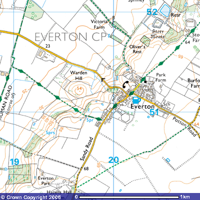
you are following the Greensand Ridge Walk up the hill along Footpath 2 from the Roman Road, once through the
kissing gate (TL 196510), instead of following the path up the hill, turn to
the north and follow the eastern side of the hedge for about 50 metres, This
gives you a choice of routes up the ridge into Everton. White, A4-sized
information boards can be seen on posts or trees at strategic points along the
walks informing you that
If
you are following the Greensand Ridge Walk up the hill along Footpath 2 from the Roman Road, once through the
kissing gate (TL 196510), instead of following the path up the hill, turn to
the north and follow the eastern side of the hedge for about 50 metres, This
gives you a choice of routes up the ridge into Everton. White, A4-sized
information boards can be seen on posts or trees at strategic points along the
walks informing you that
“access has been provided under the Ministry of
Agriculture, Fisheries and Food’s farm conservation schemes, which help farmers
and land managers protect and improve the countryside, its wildlife and
history. It is permitted access and no rights of way are being created.”
The boards include an extract of the 1:10,000 map
showing the paths and tell you that you are welcome to walk over them to enjoy
the views of the Ouse Valley and Greensand Ridge. However, they do stress that
“No person or dog should enter any woodland for the protection of
wildlife.”
These new paths are not as well used as the Greensand Ridge Walk so you
have to walk through rough grass to the kissing gate by the trees. Depending
upon the time of year, there may well be cattle grazing in this field so be
careful where you put your feet. Once through the kissing gate, the path
follows a barbed wire fence along the western side of the donkey field. You may
spot some bare patches in the grass on the slope above. Donkeys tend to urinate
in the same spot and their urine is so acidic that it burns the grass. The
field you are walking through has not been farmed for years and has become a
meadow with many species of grasses. This path can get somewhat overgrown in
summer. Long grass and bramble tendrils can obstruct the way and in rainy
weather your clothes and boots may get quite wet. Bending the brambles back and
attaching them to plants further back will assist other walkers. Overhanging
branches from the oak and other trees further on might get in the way. Breaking
off the lower twigs will help.
There is a choice of routes when you come to the end
of the donkey field (TL 196512). The one straight ahead takes you north onto
the road down the hill from Everton to Tempsford. The path going up the hill to
the east takes you into Everton village. The other, through a gap in the hedge
to the west, gives you access to the 54-metre-high Warden Hill. It is well
worth taking this latter route just to get the views. Another information board
tells you that the field was once used for growing crops but has now been
returned to grass. Archaeological maps of the area show what could be a prehistoric
hut circle on the top. Five similar sites have been identified along the top of
the ridge showing that the area was settled before the Iron Age (55BC to 500AD)
Local gossip has it that this unusually symmetrical hill is made up of a
different type of soil to the surrounding fields and underneath it lays a
Viking longboat with a dead chieftain. The Danish invasions during the 9th and
10th centuries had an impact on this area. Whether they attacked and destroyed
the Saxon farmsteads along the ridge is unknown. Certainly a Danish naval camp
for 30 ships and 2,500 men was located on the Great Ouse at Willington (TL
113503). Gannock’s Castle (TL 160529) guarded the road north, the confluence of
the Ivel and the ford at Tempsford. In 921 AD the Danes had built up their
forces to advance from Huntingdon to Bedford, no doubt using the river to
reinforce their troops. However, they were repulsed and camped at Tempsford.
The English forces, advancing from Bedford, attacked them there and the Danish
King and many Danish noblemen were killed with the remainder of the army taken
prisoner. Might one or more of them have
been buried here?
Other suggestions are that Warden Hill was an Iron Age
hill fort. Could it have been named after an ancient warden who was stationed
at the top of this hill with its commanding 360o view? Locals say
that there used to be raised earth banks circling the hill but 19th
and 20th century ploughing obliterated them. Another idea is that those people
who were wiped out during the Black Death were buried underneath it. Maybe Time
Team might be interested in determining what lies buried underneath Warden
Hill?
From the top of this hill you can get glorious views
along the ridge behind you to the east but most people are unaware that about 2,000
RAF aircrew and personnel from 138 and 161 Squadrons occupied much of the land
to the west of this hill during World War Two. It was a secret airfield,
details of which can be found in Freddie Clark’s ’Agents by Moonlight’’
and Bernard O’Connor’s ’Tempsford Airfield—Now the story can be Told’. In the wood at the bottom of the hill were
officers’ quarters, sergeants’ quarters, airmen’s barracks, ablutions,
latrines, a drying room, fuel compound and several pre-cast concrete air raid
shelters. On the weekends you might be
lucky to see original World War Two aeroplanes flying on a trip out from
Shuttleworth or Little Gransden Airfield. Some pilots do aerobatics over the
airfield which can be quite fascinating to watch. On summer evenings and also
weekends it is more probable you’ll first hear and then spot microlites flying
over,
The light sandy soils provide ideal habitat for
rabbits. You can spot their droppings in bare patches of earth along the path
and may even seen them on the walk. They are especially active alongside field
boundaries close to undergrowth in the evening sunlight, just before dusk,
skittering off when you approach to the safety of their burrows. Occasionally
you may spot some that don’t run away. They are probably affected by myxomatosis,
This virus was first noted in Uruguay, South America, and introduced in
Australia to help eradicate their rabbit population, which was destroying
grassland. It has been in Britain for decades and the signs are swelling of the
eyelids and lips, tumours and then blindness.
They then fall easy prey for foxes, owls and other birds of prey. If you
have a dog, keep it on a lead. You need to retrace your steps to get back to
the footpath. One path continues up the hill to the east. Another follows the
northern side of the hedge up the hill.
If you continue north, the next few hundred metres is
quite uneven and, depending upon the time of year and whether the grass has
been cut recently, it may be hard work through brambles and nettles. Once on the top of the rise, you get some
quite dramatic views south and west. Depending on the time of day you might see
a fox surveying its territory. This
small plantation was planted in a disused sand pit, marked on the late-19th
century maps. Although the undergrowth tends to be cleared in spring, by late
summer it can get quite overgrown. Log steps have been installed to allow you
to more easily get down the steep bank. The path emerges on the south side of
the road from Everton to Tempsford, (TL 199512), about 250 metres from the top
of the hill. Walk up the hill into the
village, aware of oncoming traffic, until you meet the T-junction where you
turn left.

![]() The
other path takes you about 100m. up the slope. In the field to the north you
might be able to make out a sunken track leading up the slope to what used to
be Warden Hill Farm. In the 1960s a new housing estate was built in the
farmyard and back fields. Once you get to the top of the hill, look over the
barbed wire fence to the south and you may notice the old stumps of what used
to be a line of huge elm trees that used to dominate the skyline, They were cut
down when they were attacked by Dutch Elm disease in the 1970s. The path
continues eastwards alongside a new hedge planted parallel to the old field boundary,
between a field of pasture on the top of the ridge in which you can often see a
horse grazing and a field to the north in which you may see one of about
two-dozen pools that dot the length of the Greensand Ridge in this area. They
were dug out of the clay to create drinking pools for cattle. Some may have
been flooded clay or gravel/coprolite pits, moats or reservoirs. It was in this
one that one of Winnie Hull’s brothers drowned. After about 100 metres you pass
the 16th century thatched, black weather-boarded ‘Winifred’s
Cottage’. The Hull family lived in it for most of the 20th century
with their eleven children. It was renovated and extended in 1999.
The
other path takes you about 100m. up the slope. In the field to the north you
might be able to make out a sunken track leading up the slope to what used to
be Warden Hill Farm. In the 1960s a new housing estate was built in the
farmyard and back fields. Once you get to the top of the hill, look over the
barbed wire fence to the south and you may notice the old stumps of what used
to be a line of huge elm trees that used to dominate the skyline, They were cut
down when they were attacked by Dutch Elm disease in the 1970s. The path
continues eastwards alongside a new hedge planted parallel to the old field boundary,
between a field of pasture on the top of the ridge in which you can often see a
horse grazing and a field to the north in which you may see one of about
two-dozen pools that dot the length of the Greensand Ridge in this area. They
were dug out of the clay to create drinking pools for cattle. Some may have
been flooded clay or gravel/coprolite pits, moats or reservoirs. It was in this
one that one of Winnie Hull’s brothers drowned. After about 100 metres you pass
the 16th century thatched, black weather-boarded ‘Winifred’s
Cottage’. The Hull family lived in it for most of the 20th century
with their eleven children. It was renovated and extended in 1999.
The 19th century Enclosure map records the field
to the south of the cottage as Brookland Close and the one to the north as
Dovehouse Close. In the back garden of the newer house you can see a fine,
white dovecote that is home to about two-dozen white doves. The path emerges
onto Sandy Road in Everton where it joins the Greensand Ridge Walk. The
semi-detached houses on both sides of the road replaced rows of one-storey
thatched cottages during the 1960s. They were built as council houses but, over
the last decade, the tenants have bought many of them.
In front of ‘Winifred’s Cottage’ is a renovated black,
weather-boarded barn, now used as a garage. Turning to the north, follow the
road into the village. Shortly afterwards on the opposite side of the road you
can see The Elms. This two-storey double-fronted Victorian villa was built as
the Pym’s estate manager’s house but is now occupied by Francis Pym’s son
Andrew and his wife, Ruth. Following the road you pass the entrance to Warden
Hill housing estate. Standing on the grass triangle you will see the
Everton-cum-Tetworth village sign. This intricately carved oak depicts Oliver
Cromwell, stooks of wheat and St Mary’s Church tower. It was carved by ** and
erected in 19 * * by a group of villagers following a VJ Day celebration. The
footings are Greensand from one of the local sand pits. Warden Hill Farm, now a
private residence, stands on the northern side of the road.