Footpath 13
Direction E-W Distance 90m.
![]()
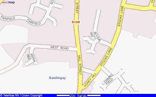
![]() Footpath 13 is the shortest public footpath
in Gamlingay. It starts (or finishes) at TL 237518 and ends (or begins) at TL
238518. On the 1601 map it was marked as comen lane from controverfy Tho.
Ratford. The property and land to the south of the lane was owned by Clare
Hall, Cambridge, and consisted of 1a.2r.12p in the occupation by Fr. Ratford.
Fr(ancis) Ratford also farmed Clare Hall’s 4a.2r.20p. field on the west side of
Mill Street. Mrs Brudnell owned the
adjoining property to the north. The 1a.3r.5p. plot was in the tenure of
Rat,Sm. (sic). It appears to have been a short cut for farmers and
agricultural labourers between the Milne Crofte allotment on Honey Hill and Cow
Lane off Mill Street.
Footpath 13 is the shortest public footpath
in Gamlingay. It starts (or finishes) at TL 237518 and ends (or begins) at TL
238518. On the 1601 map it was marked as comen lane from controverfy Tho.
Ratford. The property and land to the south of the lane was owned by Clare
Hall, Cambridge, and consisted of 1a.2r.12p in the occupation by Fr. Ratford.
Fr(ancis) Ratford also farmed Clare Hall’s 4a.2r.20p. field on the west side of
Mill Street. Mrs Brudnell owned the
adjoining property to the north. The 1a.3r.5p. plot was in the tenure of
Rat,Sm. (sic). It appears to have been a short cut for farmers and
agricultural labourers between the Milne Crofte allotment on Honey Hill and Cow
Lane off Mill Street.
During the ploughing of a possible
earthwork ridge on the western side of Mill Street many early Neolithic and
Bronze Age flints were found, including cores, blades, a ‘tranchet’ arrowhead
and two barbed and tanged arrowheads (SMR2396, 2396a; TL237521).
When The Falcon public house was built on
the south side of the lane, it would have been provided access for the brewery
ale carts to the back of the premises.
In 1670 the Baptist Church on Honey Hill was founded and the lane provided access. The Church Hall was erected in 1848 and The Manse, where the Minister lived with his family, in 1904. The notice board outside the church indicates Sunday Services at 10.45am. The Home Group meet Mondays at 10am and Thursdays at 7.45pm. Women in Partnership meet every 2nd and 4th Tuesday each month at 3.pm.
Hope Cottage
The Old Manse