Footpath
2
Direction
ESE then SSW Distance 400 m.
![]()
![]()
![]()
![]()
![]()
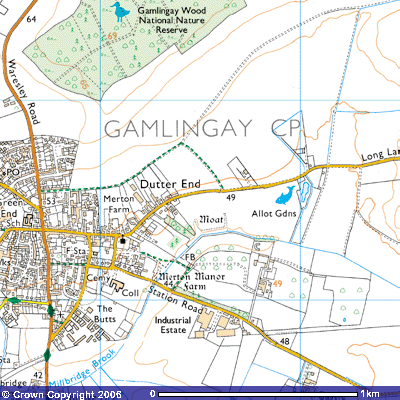
![]() The start of Footpath 2 is at the end of St
Mary’s Close, a cul-de-sac immediately to the south of St Mary’s Church
(242523) and The
Emplins, a fine example of a half-timbered medieval house. There used to be
a kissing gate providing access to the field. A grassy path follows the south
side of the meadow, for about 200 metres almost SE towards Millbridge Brook. On
the 1601 map the field was marked as Mertonage, one of many fields in
the parish owned by Merton College, Oxford.
The start of Footpath 2 is at the end of St
Mary’s Close, a cul-de-sac immediately to the south of St Mary’s Church
(242523) and The
Emplins, a fine example of a half-timbered medieval house. There used to be
a kissing gate providing access to the field. A grassy path follows the south
side of the meadow, for about 200 metres almost SE towards Millbridge Brook. On
the 1601 map the field was marked as Mertonage, one of many fields in
the parish owned by Merton College, Oxford.
The first reference to this manor was in
1198 when it was in the possession of Roger, son of Remphrey. After passing
through the hands of a series of landowners, the estate rents were paid in 1260
by Richard of Leicester, the bailiff of Bedford. When he sided with some barons
against the king he had his Gamlingay estate confiscated. In 1268 it was
mortgaged by William of Merton, who later became the Bishop of Rochester.
Perhaps for religious reasons, a William of Leicester then gave Walter the
whole of the Gamlingay estate and half the church lands. The rest was given to
Walter’s house of scholars at Merton in Surrey, later to become Merton College,
Oxford. Walter immediately made the estate over to his scholars with him
receiving the rent until his death..
Merton College
records show that, apart for the years 1302 – 1314 and 1352 – 1355, their
bailiff administered the manor until 1362. Ever since it was leased to a tenant
and it remained in college hands until 1967. When the original manor house was first built to the east of
St Mary’s church is uncertain. A large moat
surrounded it with the brook forming its eastern side. The only remaining part
today is on the north side, 360 feet (133.2m) long, 30 feet (11.1m.) wide and
six feet (2.1m.) deep. The rest has been filled in (SMR 1139 TL242523).
It had a number
of residential, farm and administrative buildings. The farm servants had their
own house. A new kitchen was built in 1280. The bailiff’s house, or camera , was built in 1328. A solar, sun
room, and a porch were added later. Around a courtyard the farm buildings
included a dairy, a buttery, a brick kiln, a dove-cot, a steeping house, stock
sheds, sheepfold and vegetable garden. It had at least two barns, one for the
lord’s grain, another for the villagers’ tithes. The whole complex was
surrounded by a wall with one large and several small gates. (Lowry, Estates of Merton, pp.43, 174, 189,
191-2) In 1516 450 trees were cut down between the village and Gamlingay Wood.
The remaining stumps are said to have given rise to the field being called The
Stocking’. More historical detail can be found on this link: Merton manor.
A
survey in 1807 showed that Merton Manor Farm had a brewhouse, a dovehouse,
boarded and thatched stables, a granary of brick, board and thatch, separate
barns for wheat, barley and rye, other ‘hovels’ and houses for grain and stock
(Merton Mun. 5/24). Merton Manor farm house comprised a timber framed central
range, thought to be open to the roof, and a west cross-wing, both built in the
late 15th or early 16th century. The east cross-wing is
of the late 16th century. It had a brick 17th or 18th
century dovecot and a thatched, aisled barn. The inscription TB 1600 is found on one post. (R.C.H.M. Cambs. i. pp.104, 110)
The footpath is in the field immediately to the north of the farm gardens. Another path runs along the northern side of the meadow, a short cut between St Mary’s Church and Merton Grange, the house occupied by the village’s Lord of the Manor. At the end of the fence on the south side of the meadow there is open wooded ground through which a track takes you south onto to Station Road by the Martin Barrow bridge, marked on the OS map as at 49 m. above sea level. The 1601 map marked it as a stone bridge. Who was Martin Barrow?
Another website on St Mary’s Church
Footpath 2 veers NE alongside
the brook for about 100 metres to a wooden footbridge. Standing on it and
looking back across the meadow into the village you can glimpse what Gamlingay
looked like for centuries, a typical English rural village. Once you cross the
bridge the path follows the hedge for about 150 metres alongside a smallholding
in which you’ll probably hear chickens.
In the fields to the east an
Early Mesolithic to Late Bronze Age (10,000 BC to 701 BC) flint knife and
arrowheads were found (SMR 11585, 25; TL24515244, 24745235). The 19th
century terraced cottages at the end were built for estate workers on Merton
Grange farm. You meet the old driveway into Merton Grange (TL244522) and turn
south past some mature pine trees for about 130 metres to the gateway on Station
Road (TL244520). The two-bedroomed Victorian cottage was formerly the gate
house of the Merton Grange estate. It was renovated in 2005 and was on the
market in 2006 at £275,000. The OS map notes that it is 44 metres above sea
level.
Immediately to the south
across Station Road is the site of an early to middle Saxon settlement.
Archaeological excavation in 1997 showed that it was occupied between the 5th
and 7th centuries AD. Evidence found on the site included ditches,
post holes, pits, fourteen sunken-featured Grubenhauser, a droveway and a long
timber building with an enclosure. Fascinating details can be found on the
‘Saxon Gamlingay – Excavation at Station Road’ pages of the Gamlingay website.
To the SE you can see the
buildings of the Gamlingay Industrial Estate.
Railway Station
The field to the SW running
down to Millbridge Brook has been purchased by the Parish Council and there are
plans to develop it as a sports field. The Jubilee Walk follows the eastern
side of the brook from Martin Barrow bridge (243522) to the disused
railway bridge (242518). A path runs up
the western bank of the brook behind the tennis courts and then up onto the
playing fields of the Community Centre.