Footpath
4
Direction
N to S Distance c.700m.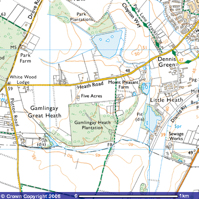
![]() Back to map
Back to map
![]()
![]()
![]()
![]() Footpath 4 starts on the south side of
Heath Road, about 300 metres west of Mount Pleasant Farm. This renovated
farmhouse had several sand pits in operation during the 19th century
building boom following the 1846 Enclosure Act. Heath Road ascends the gentle
scarp of the Greensand Ridge out of Gamlingay towards Everton (227517).
Footpath 4 starts at about 52 metres above sea level opposite what were
probably 19th century agricultural labourers’ cottages. They were
probably made out of bricks from the Belle Vue brickworks (shown on the map by
Pit (dis)) at Little Heath. Just as you enter the field you can see another 19th
century farm building. The spaces between the red bricks on the gable end
suggest it was probably an onion house, where the crop was stored to dry out
before being taken to Potton or Gamlingay Station for sale in the London
markets.
Footpath 4 starts on the south side of
Heath Road, about 300 metres west of Mount Pleasant Farm. This renovated
farmhouse had several sand pits in operation during the 19th century
building boom following the 1846 Enclosure Act. Heath Road ascends the gentle
scarp of the Greensand Ridge out of Gamlingay towards Everton (227517).
Footpath 4 starts at about 52 metres above sea level opposite what were
probably 19th century agricultural labourers’ cottages. They were
probably made out of bricks from the Belle Vue brickworks (shown on the map by
Pit (dis)) at Little Heath. Just as you enter the field you can see another 19th
century farm building. The spaces between the red bricks on the gable end
suggest it was probably an onion house, where the crop was stored to dry out
before being taken to Potton or Gamlingay Station for sale in the London
markets.
After about 200 metres you
pass the eastern side of Gamlingay Heath Plantation. To the east you might
catch glimpses of the flooded clay pits of Belle Vue Brick and Tile Works.
These were opened by the Dennis family in the 19th century to
exploit the local clay. Many of Gamlingay’s Victorian cottages and houses,
including the two you’ve just passed, were built using local brick and tiles.
After the works closed, the lakes were stocked for private fishing.
Several worked flints were
found walking along this footpath so keep a look out. Five Mesolithic (10,000
BC to 4,001 BC) ‘pygmy flints’ were found near the brick works (SMR 2393;
TL233515), a flint scraper and flakes (SMR 60; TL236517) as well as a Neolithic
(4,000 – 2,201 BC) barbed arrowhead, three flint knives, seven scrapers, two
fabricators, a borer and a two-grooved implement (SMR 2393a; TL233515). With
them were two or three hundred flint flakes suggesting at least a temporary
prehistoric settlement, probably hunting animals by the brook.
In
medieval times there was a small hamlet in this area known as Newton on the
Heath. There were houses, outbuildings and fields recorded in 1230 AD. They had
disappeared by 1279 and the cultivated land reverted to heath and common land
(SMR 8082, 2382; TL 22005100).
At the end of the wood there
is a wooden footbridge (TL227511) over a tributary stream that drains east from
Gamlingay Great Heath into Potton Brook. It is about 42 metres above sea level
so you have dropped 10 metres from the road. This marks the County Boundary
between Cambridgeshire and Bedfordshire. The path now becomes a bridleway south
into Potton, past extensive sand and gravel pits, the east side of the Potton
Travellers Site, the disused Cambridge to Bedford Railway line (TL223498) and
ends on Everton Road (TL223497).