Footpath 5
Direction NW – SE Distance 1.4 km.
![]()
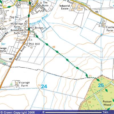
![]() Footpath 5 has arguably the best views of
all Gamlingay’s footpaths and bridleways. It starts about 100 metres south of
Mill Bridge on the road out of Gamlingay towards Potton (TL238515). It is an
ancient track across what was called in medieval times as the South Field. It
follows what is known today as the Clopton Way southeast up the hill towards
Potton Wood. On Thomas Langdon’s 1601 map it was marked as the London Waye,
an ancient track which continues south-east through Cockayne Hatley towards the
deserted medieval village of Clopton and then south towards Royston. Before the
Cambridge to Bedford Railway was constructed in the mid-19th
century, the Clopton Way would have continued northwest over Millbridge Brook
to join Park Lane (Footpath 8), towards Gamlingay Cinques and St Neots. The
fields on both sides of the Footpath by the road were excavated for sand, the
Cambridgeshire Greensand, for use in the construction industry. Bibby’s Old
Sand Pit, the house on the corner, is aptly named. A well was marked on the early maps.
Footpath 5 has arguably the best views of
all Gamlingay’s footpaths and bridleways. It starts about 100 metres south of
Mill Bridge on the road out of Gamlingay towards Potton (TL238515). It is an
ancient track across what was called in medieval times as the South Field. It
follows what is known today as the Clopton Way southeast up the hill towards
Potton Wood. On Thomas Langdon’s 1601 map it was marked as the London Waye,
an ancient track which continues south-east through Cockayne Hatley towards the
deserted medieval village of Clopton and then south towards Royston. Before the
Cambridge to Bedford Railway was constructed in the mid-19th
century, the Clopton Way would have continued northwest over Millbridge Brook
to join Park Lane (Footpath 8), towards Gamlingay Cinques and St Neots. The
fields on both sides of the Footpath by the road were excavated for sand, the
Cambridgeshire Greensand, for use in the construction industry. Bibby’s Old
Sand Pit, the house on the corner, is aptly named. A well was marked on the early maps.
The mill of Millbridge was a
windmill. It stood on the east side of Potton Road, a few hundred metres
further up Mill Hill at about 50 metres above sea level (TL237051119). It was a
19th century smock windmill, octagonal in shape with a one-storey,
tarred brick base, probably replacing the much earlier one marked on the 1601
map. The upper part was timber built and it stood in a brickyard. In the 1930s
its sails and fantails were gone and it was worked by an engine, With the development of diesel and electric power, it fell
into disuse and, as it was leaning backwards, was demolished (SMR 2438).
A tarmac road runs past Clopton Cottage,
some stables and paddocks and Millbridge Lodge, a residential care home. The
field track continues southwest up a gentle slope
towards Potton Wood. Just before the path crosses the field you can see a farm
trailer on the edge of the track which belonged to E. J. Gore, Gamlingay. 262
was the telephone number. Analysis of aerial photographs of the fields ahead
has revealed evidence of trackways, rectangular enclosures and raised field
boundaries which indicate very early farming (SMR 5373; TL245514; SMR 9967
TL236510). There’s evidence of medieval cultivation with its ridges and furrows
(SMR11400; TL245510; SMR 11408 TL255512). This footpath would have been the
route that local farmers and agricultural workers took to get to their fields.
On the 1601 map it shows the track crossing Broade
Waye which ran northeast across East Field. The field to the northeast was
called Foxen Furlong. After a few hundred
metres it crosses what were called Crabtree Haden and Longe Brache, fields
belonging to Abraham Jacob and Richard Smithe. The field at the top of the hill
to the north was called Avenelles field, one of many owned by the Avenell family. They were one of the major
landowners in the parish following the Norman Conquest. An oval, medieval,
bronze seal with an eye and pierced heart was found in the area in the early 20th
century (SMR. 2356).
An overgrown drainage ditch, probably dug
in the 19th century after the Enclosure Act in the 1840s, runs
alongside the footpath all the way up the hill. In the summer months when there
has been no rain it is often dry. There are views in all directions along the
track. Looking west you can see the woods of Woodbury and Tetworth and the
Sandy TV transmission tower on the skyline. There are fine views of Gamlingay,
which appears to be nestled in woods. To the north there are views over gentle
sloped arable fields towards the factory buildings and storage yards of Station
Road Industrial Estate. To the east the skyline is Potton Wood and the woods of
Hatley Park. The water tower at the southern end of Potton Wood stands out.
There are views to the south over more arable fields towards Potton. The hedge
running down the slope in the field to the east follows the parish, county and
European Parliament Constituency boundary between Gamlingay and Potton,
Cambridgeshire and Bedfordshire.
You
will notice the first part of the track is sandy soil, eroded over the
millennia from the underlying Cambridge Greensand. As you start to ascend the
slope it changes to clay. Note the gravel, pebbles, rocks that have been
exposed by rainwater over the centuries. It was common for Saxon and medieval
peasants, more recent agricultural labourers as well as local farmers to dump
them on the track to provide better foundations. Cartwheels and animal hooves
left deep ruts which, if not regularly filled in, resulted in stream beds after
heavy rain. Most of these stones were picked off the surface of the surrounding
fields, left there after the last ice sheet retreated northwards about 11,000
years ago, leaving in its wake the boulder clay which most of East Anglia is
covered with.
When you pass under the telegraph wires at
the top of the hill the path levels out and veers
southeast as a grassy track towards the parish boundary (TL248507). It then
follows the boundary west to the corner of Potton Wood. Although the farm track
follows the northern edge of the wood, there is a footpath into the wood on
your right. Two wooden fences prevent vehicular access. A white circular disc
with a yellow arrow indicates Clopton Way continues into the wood where a sign
by Forestry Enterprise tells you that “Our woodlands are open for quiet
recreation. Dogs should be kept under close control or on a lead. Please
observe and warning notices for your safety.”
The end of the footpath is not only one of
the highest points in the parish at 73 metres, but pretty much the furthest
south. At this point on the 1601 map was written Gilberte’s crosse. On the opposite side of the valley to the
north, on the border with Waresley parish, was Waresley Crosse. Gamlingay Crosse was on
Long Road going east out of Gamlingay towards Little Gransden. These crosses
marked the cardinal points along what was called the Procession or
Perambulation Waye. Until the practice was suppressed following the Reformation
in the 16th century, it was common for all the parishioners to walk
around the parish boundary on the ‘Rogation Days’ in June. They were beating
the bounds to ensure everyone knew where their parish boundary ran. The
booklet, ‘Gamlingaye’s Procession Waye’ which details the history of the
walk and describes its route can be read in the local library or purchased from
Bernard O’Connor at fquirk202@aol.com .
Although the
Procession Way wasn’t marked on the 1601 map along the southern boundary of the
parish, it continued along the northern edge of Potton Wood until it reached
the ‘Gilbert Crosse’ (TL 24805060), It marked the
junction of the Procession Way with the London Way, the route southeast from
the village once you pass over Millbridge. This was the road through Cockayne
Hatley to Royston. Why it was called the Gilbert Cross is uncertain. Internet
research found that a likely Gilbert was born at Sempringham, in 1083, the son
of Jocelin, a wealthy Norman knight. whose domain was
in the Lincolnshire Wolds, in the villages of Sempringham and West Tonington. He was sent to France to
study and returned to England to receive the benefices of Sempringham and
Tirington from his father. He established a local school and was appointed a
clerk, the household secretary of Bishop Robert Bloet of Lincoln. The next
bishop, Alexander, ordained Gilbert as a priest.
When his father
died in 1131, Gilbert returned to Sempringham as their Lord of the Manor and
parish priest. In the same year he began acting as a spiritual adviser to a
group of seven young women who expressed a willingness to live an austere a
monastic life of prayer and helping others. His response was to provide them
with a large house next to the church where they lived with some lay brothers
who worked the land to produce food. They all followed the Rule of St Benedict.
Mixed religious communities were quite accepted in Norman times.
After he helped
set up a number of similar religious communities in Lincolnshire and Yorkshire,
Gilbert decided they ought to be incorporated into an established religious
order. He went to Citeaux in Normandy in
1148 to ask the Cistercians to take over his communities. When the Cistercians
declined to take on the governing of a group of women, Gilbert, with the approval
of Pope Eugene III, continued the Community with the addition of Canons Regular
for its spiritual directors and him as their Master General. The Community
became known as the Gilbertine Order, the only English religious order
originating in the medieval period and known for allowing religious men and
women to live and work together. They set up a number of leper hospitals and
children’s orphanages.
Gilbert imposed a
strict rule on his Order and became noted for his own austerities and concern
for the poor. He was imprisoned in 1165 on a false charge of aiding Thomas a Becket, the Archbishop of Canterbury during the latter's
exile but was exonerated of the charge. He was faced with a revolt of some of
his lay brothers when he was ninety. They complained of being over-worked and
under-fed, but he was sustained by Pope Alexander III.
Over the years a
special custom grew up in the Gilbertine houses called "the plate of the
Lord Jesus." The best portions of the dinner were put on a special plate
and shared with the poor, reflecting Gilbert's lifelong concern for less
fortunate people. Today’s ‘Operation Rice Bowl’ echoes that habit, eating a
simpler meal and letting the difference in the grocery bill help feed the
hungry. Throughout his life Gilbert lived simply, consumed little food and
spent a good portion of many nights in prayer. Gilbert resigned his office late
in life because of blindness and died at Sempringham in 1189, aged 105. He was
canonized, made a saint, in 1202 and his feast day is February 16th.
By the Reformation
when Henry VIII closed down all the monasteries and religious houses the
Gilbertine Order had twenty-six monasteries and the nearest one to Gamlingay
was at Chicksands. Whether Gilbert visited Gamlingay, local men and women joined
his order or one of the parish priests collected money to help his order is
unknown. Maybe the Gilbert Cross was erected by local people in his honour who
visited it to pray on his feast day. There is no sign of the cross today.
Whether it rotted away or was dismantled is unknown.
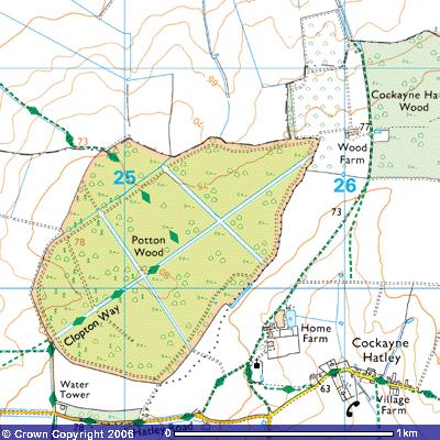
![]() The Footpath ends when it enters Potton
Wood at about 75 metres above sea level (TL249506). Many paths run through this
nature reserve. The Perambulation Walk or Procession Waye ran along its
northern boundary east towards Hatley St George and west along what was called
Potton waye in 1601 to the road from Gamlingay to Potton.
The Footpath ends when it enters Potton
Wood at about 75 metres above sea level (TL249506). Many paths run through this
nature reserve. The Perambulation Walk or Procession Waye ran along its
northern boundary east towards Hatley St George and west along what was called
Potton waye in 1601 to the road from Gamlingay to Potton.