Footpath 7
Direction: SE – NE Distance:c.1,400m.
![]()
![]()
![]()
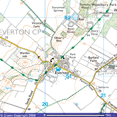 This footpath, part of the
Greensand Ridge Walk, starts just beyond the corner of the road by the Thornton
Arms public house and Manor Farm, Everton. The latter belonged to Everton Manor
and parts date back to the 16th century. There are signs that it was
once moated. This was not defensive - more an attractive feature which also
provided the owners with fish for Fridays and over Lent as well as ducks, eggs
and frogs. During the anti-Catholic period after the Reformation, many of the
large Catholic landowners were fined and Catholicism was forced underground.
Those wanting to "keep their faith" had to do so in secret and, in
many of the larger households, a special hiding place was constructed for a
visiting priest. These "priest holes" were often in a recess up the
chimney, others were under stairs, behind oak panelling or in the roof. There
is said to be such a "priest hole" in Manor Farm.
This footpath, part of the
Greensand Ridge Walk, starts just beyond the corner of the road by the Thornton
Arms public house and Manor Farm, Everton. The latter belonged to Everton Manor
and parts date back to the 16th century. There are signs that it was
once moated. This was not defensive - more an attractive feature which also
provided the owners with fish for Fridays and over Lent as well as ducks, eggs
and frogs. During the anti-Catholic period after the Reformation, many of the
large Catholic landowners were fined and Catholicism was forced underground.
Those wanting to "keep their faith" had to do so in secret and, in
many of the larger households, a special hiding place was constructed for a
visiting priest. These "priest holes" were often in a recess up the
chimney, others were under stairs, behind oak panelling or in the roof. There
is said to be such a "priest hole" in Manor Farm.
During repair work on the house in the late 20th
century, the removal of some floorboards in one of the downstairs rooms
revealed numerous clay inkwells strewn on the earth floor about 70cm. (2 ft.)
below. This suggests that the room had been used as a schoolroom at some time.
Also found in the walls were two mummified rats, a mummified cat and a child’s
bonnet. These are supposed to have been immured to deter witches.
There are reports of
ghosts having been seen and heard in the house and other strange stories. One
tells of a tunnel connecting it to the church and another of a well in the
farmyard that collapsed outwards. Rather than the brick wall collapsing into
the water a section of the side disappeared. On investigation an enormous
cavern was revealed, full of water, said to stretch all the way to Gamlingay!
The Thornton Arms Public House at
the junction with the Potton to Sandy Road, at 66 metres, is the highest pub in
Bedfordshire and once one of seven beer-selling establishments in
Everton in the 19th century. It was built in 1852 and named
after the Thornton family, who resided at Moggerhanger and later at Woodbury
Hall. Their sons were involved in local, national and international affairs as
Members of Parliament, Justices of the Peace, members of the armed Guards,
merchants with Russia and India, London bankers and financiers with several
rising to become directors of the Bank of England. In 1733 Godfrey Thornton
married Margaret Astell, William’s second child, and when her brother Richard
died in 1777 without an heir to the Woodbury estate, their son William acquired
it by “royal sign manual”. He added Astell to his name and adopted their family
coat of arms and moved into Everton House. He and his male descendants then
took over as the Lord of the Manor, providing employment opportunities and
rented accommodation to the estate workers.
His nephew, also called
William Thornton, used the same “royal sign manual” to adopt the name Astell
and keep hold of the estate in 1807. He had married into the Harvey family of
Ickwell Bury and moved, with his wife and two sons, into Everton House whilst
he was MP for Bridgewater from 1806 – 1832. He was Lieutenant- Colonel in the
Bedfordshire Militia, the last Colonel of the Royal East India Volunteers and
Chairman of the Honourable East India Company. Between 1841 and 1847 he was MP
for Bedfordshire. His heir, Richard William Astell, who lived in Everton House,
probably built the pub. As mentioned earlier, John Harvey Astell moved into
Woodbury Hall after a trip to the Far East. Apart from providing a vital
community service for the locals, you can often see other ramblers, walkers and
cyclists. Drinks and hot food and snacks are available at
lunchtime and most evenings, worth stopping for as the next pub on the
Greensand Ridge Walk, the Wheatsheaf in Gamlingay, is several kilometres walk
away.
In the 19th century many
of the women and girls of the village used one of the pub’s upstairs rooms as a
plaiting school. Several patterns of straw plait were made with 3, 5 and 7
straws. Mrs Brooker, a local painter, recalled how
“They had
to split the straws and put them through what looked like a small mangle to
flatten them. On Saturday evenings they
took the plait to Potton market where they it was sold to a man who came from
Luton who had it made into hats. They
were paid a farthing a yard (£0.00125) for 3 straw plait, a halfpenny for 5
straw plait, and three farthings for 7 straw or fancy patterned plait. They
then used to walk home with a joint of meat hurch for Sunday dinner they had
bought with the money. The rest of the week they ate home produced pork that
had been preserved in brine as every housewife had a pork pot in her
kitchen.”
Continuing north
along Church Road one passes some attractive terraced houses, built during the First
World War for the agricultural workers on the Pym estate. The Village Hall,
provided by the Pym and Astell families, is a well-used focal point in the
village. At the crossroads carry straight on. The road to the northwest leads
to the start of Footpath 8 (TL 202502), another
ancient trackway that passes some of Everton’s oldest properties, down Victoria
Hill, across Tempsford Airfield towards Gibraltar Farm and Tempsford. The road
to the right leads to Park Farm, part of what used to be Everton House.. There
is access via Green Lane, the finest holly hedge in Bedfordshire, to the Old
Vicarage and Potton Road.
Everton House was
built on land east of St Mary’s church that belonged to Clare College,
Cambridge. The Master and Fellows had acquired the estate after the
Reformation. Construction is thought to have started in 1690 when William
Carey’s medieval manor house at Story Moats became uninhabitable. Carey is
thought to be one of Henry Carey, 1st Baron Hunsden’s twelve
children with a claimed to be descended from one of Henry VIII’s bastard
children. By 1712 there was a huge, three-storey mansion. The following year,
William Astell, a director of the South Sea Company of London, acquired
this estate from Carey, the last representative of his family, as well as considerable
property in Biggleswade, Northill, Blunham, Moggerhanger, Boston, Tempsford and
Hail Weston. The house was said to have fallen into such a poor
state of repair by the mid-19th century that the College was not prepared to
spend any money on renovating it. John Harvey Astell came back from China in
1851, got married in 1853 and, without a country house, bought Woodbury Hall.
Whilst waiting to move, much of the furniture, paintings and Chinoiserie were stored
at Hasells Hall and Ickwell Bury. He rented Tetworth Hall for a year where his
youngest daughter Clara was born. There was a fire at Everton House in 1858
that led to the rest of the building being pulled down. The only remaining
evidence is the laundry block, now called Park Farm (TL 204513), the large
house to the east of the church.
The field just before the
white five-bar gate at the entrance to Woodbury Park is called Brewhouse Close.
A thatched gatehouse cottage used to stand beside the gate but it fell into
disrepair and was demolished in the early-20th century. There used
to be a saw pit (now built over) beside the road. It belonged to the Lord of
the Manor who lived at Everton House.
Chains were fastened around any trees from the estate that were blown
down in the gales or cut down for timber and hauled by carthorses to the pit.
They were positioned lengthways to allow long slices to be cut from the trunks.
Using a double-handed long saw, one man stood in the bottom of the pit and
pulled down, the other stood on top of the tree trunk and pulled up. Once they
got the rhythm, it took two men ten hours to saw through the length of a
medium-sized tree. At the beginning of this century they were paid 3s. 6d
(£0.17) a foot. The planks were then piled up and seasoned until they were
ready for sale. When the pit fell into disuse it was used as a dump for garden
rubbish and gradually filled in. A sweet-smelling lime tree now grows over it.
If the church is
not open, the keys are available from one of the churchwardens. Details about
how to obtain one are posted in the church porch. St Mary’s Church is said to
be a 12th century building but if you examine the base of the chancel walls you
can see rough-hewn sandstone blocks upon which a wooden building stood that
probably pre-date the Norman occupation. Inside the church are memorials to the
landowning members of the Pedley, Astell and Winche families. A booklet, ‘The
History of St Mary’s Church’, is available inside the church.
In the graveyard immediately behind the church you can find
the tombstone of Rev. John Berridge (1716-1793), who also helped put Everton on
the 18th century map. He was a controversial clergyman, a contemporary of John
Wesley, the founder of the Methodist Church and instrumental in spreading the
Non-Conformist church in Bedfordshire and surrounding counties. His Sunday
‘hell, fire and damnation’ sermons used to attract so many visitors that the
churchyard was often full. On one occasion thirty people had come from thirteen
miles away, having set off at two in the morning. Berridge's text was 2 Timothy
3:5: 'Having a form of godliness, but denying the power thereof.' According to
Mrs Blackwell, an eye-witness
“The presence
of God really filled the place. And while poor sinners felt the sentence of
death in their souls, what sounds of distress did I hear! The greatest number
of them who cried or fell were men; but some of women, and several children,
felt the power of the same almighty Spirit, and seemed just sinking into hell.
This occasioned a mixture of various sounds, some shrieking, some roaring
aloud. The most general was a loud breathing, like that of people half
strangled and gasping for life. And indeed almost all the cries were like those
of human creatures dying in bitter anguish. great numbers wept without any
noise; others fell down as dead; some sinking in silence, some with extreme
noise and violent agitation. I stood on the pew-seat, as did a young man in the
opposite pew, an able-bodied, fresh, healthy countryman. But in a moment, while
he seemed to think of nothing less, down he dropped, with a violence
inconceivable. The adjoining pews seemed shook with his fall. I heard
afterwards the stamping of his feet, ready to break the boards, as he lay in
strong convulsions at the bottom of the pew. Among several that were struck
down in the next pew was a girl who was as violently seized as him. When he
fell, Blackwell and I felt our souls thrilled with a momentary dread; as when
one man is killed by a cannon-ball, another often feels the wind of it. Among
the children who felt the arrows of the Almighty I saw a sturdy boy, about
eight years old, who roared above his fellows, and seemed in his agony, to
struggle with the strength of a grown man. His face was red as scarlet; and
almost all on whom God laid his hand turned either very red or almost black.”
(Curnock, N. (1938), 'Journal of John
Wesley', vol.4, London, p.318)
The
booklet, ‘Rev. John Berridge, Vicar of Everton, Bedfordshire’, can be found in
the local libraries. Not far from his tomb is the memorial to six RAF personnel
who lost their lives whilst operating at Tempsford Airfield.
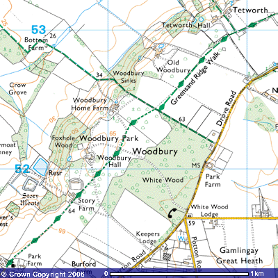
Notice the sign
on the gate. The owners of the estate are at liberty to restrict public access
one day a year, usually Good Friday. Once through the gate the metalled road
continues towards Woodbury Hall. Both sides are lines with tree saplings that,
over the coming decades, will produce another grand avenue. To the west you can
see a hedge blocking the view down the hill. Until the Second World War there
was a line of mature elm trees that dominated the ridge top between Hasells
Hall and Woodbury Hall. These were cut down to make it easier for pilots taking
off and landing at the airfield at the bottom of the hill.
On the other side of the
hedge to the west there used to be another local landmark, marked on the map
(TL 203517) as ‘Oliver’s Rest’, but known by the locals as ‘Cromwell’s Rest’.
This was an 8-metre (25 feet) high full moon gate with seats inside. Some say
it was erected on site where Oliver Cromwell pitched his tent to overlook his
troops before marching on to London during the Civil War in 1647. It was most
likely an 18th century folly associated with the Astell family's Everton House
that was occupied until about 1850. It
used to be a favourite spot for courting couples but was largely dilapidated
after the Second World War.
In the field to the east,
immediately behind the Old Vicarage (TL 205513) aerial photographs have picked
up several large circular or near circular marks that look as if they are
prehistoric. The smaller could well be a Bronze Age ring ditch. This was a
defensive earthwork from about 1,500 - 500 BC. A large circular trench was dug
and the earth thrown up as a mound around a wall of tree trunks to form a
stockade. Inside would have been their huts and animal enclosures. The larger
two could be Iron Age enclosures from 500 BC to 55AD. They too probably had a
wooden stockade around them to protect the houses and livestock.
The photographs also show
a wide trackway running north-northwest between the church and Park Farm. It
was a continuation of ‘Green Lane’ that led from the Everton to Potton Road,
Everton House and the church to Story Moats.
To the north and south of this ancient trackway are the outlines of
house platforms, enclosures and field boundaries that suggest that this is the
site of a deserted medieval village.
It is thought that the
cottages could have been demolished and the tenants re-housed south of the church
when Everton House was built in the early-18th century. There is
evidence of this happening in some stately homes when the occupants wanted a
nice view across rolling countryside. Certainly some deserted medieval villages
were the result of landowners clearing their estate to be used for grazing
sheep. Maybe this happened in Everton.
About 600
metres further along the road you cross a cattle grid and pass Story Farm (TL
207517), a Victorian farmhouse. See if you can spot the elaborate plaque showing
that the Astell family built it in 1884, when the estate was being modernised.
After the farm buildings there is the attractive red-bricked gardener’s cottage
with ornate eaves. A plaque on the side shows that John Harvey Astell built it
in 1868. Behind it is a large walled kitchen garden.
At the bottom of the
slope, a few hundred metres west of Story Farm Wood, lies Story Moats (TL
204518). There was an 11th century manor house on the island. It was
not a defensive moat but an ornamental one used for fish breeding. Being a
Christian country in those days, everyone had to give up meat during Lent and
on Fridays so fish was a valuable commodity. Story Moats is one of
Bedfordshire‘s best-preserved moated sites and is listed as of historical
importance as an excellent example of a water management complex. It lies about
400m. west of Story Farm at the foot of the Greensand Ridge, where several
springs emerge. The earliest evidence of occupation on this 3.26-hectare (8
acre) field is a series of earthworks near the moat. These suggest that there
was a small settlement there by at least 1140, known as Woodbury or Westthorpe.
This was at the same time as the Norman church in Everton was being built. A
hollow way or approach track, about 1 metre deep, leads southeast up the side
of the ridge towards St Mary’s Church.
Today there is
no sign of the house on Story Moats. Over time the timbers have rotted
away. Some preserved oaken sluice gates
or hatches have been found submerged in the moat. They separated the ponds from
each other. Other excavations in the moat have revealed broken pottery from the
13th - 14th century and roof tiles, clay pipes and other pottery from the 16th
- 19th century. The whole site is now
much overgrown with trees and undergrowth and the island is used a pheasant
run. A pond above the site has been banked up to provide a reservoir for Story
Farm. There used to be primroses, violets, kingcups, horsetails and other wild
flowers and plants around the site and wild birds that nested on the water's
edge. Here and in the nearby meadows
villagers used to gather cowslips, elderberries, crab apples sloes and
blackberries for making wine and jams, and “conkers” and acorns to play with.
There were
several large manors in this area during Norman times. Everton Manor, sometimes
referred to as Netherbury, was one of many granted by King William to Ralph de
Beauchamp. His family are claimed to have built Bedford Castle and owned many
estates in Bedfordshire, Their Everton estate passed into the hands of Nicholas
Burnard who held Everton in 1243. It
was he who is thought to have built a fortified manor house surrounded by a
wide inner moat and a less deep outer moat. It had been completed by 1306 when
he sold it to Walter Langton, Bishop of Coventry and Lichfield for £100. At that time Everton must have been quite a
busy settlement as the bishop gained permission to hold a market every
Wednesday, (presumably in the field near the manor) and an annual three-day fair
on the Vigil, Feast and Morrow of St Bartholomew (August 24th). Whilst it was
initially a fortified house, by the 14th century there was no need
for defence. Moats had become a picturesque element of Norman gardens. Along
with the medieval garden there were a traditional requirement of the medieval
French Lady of the Manor. The bishop would have had a brisk ride up to the
church when he visited the village if he was entertained at Everton manor.
The
earliest documentary evidence of the parishes of Everton and Tetworth comes
from the Domesday Book. This was written in 1086, two decades after the Norman
invasion, to ensure King William and his French Lords knew who owned what land
in the areas under their control. Commissioners were required to find how many
hides (an area of land that produced enough for one household) there were in
each manor and how many ploughs were in demesne, (the land owned by the lord of
the manor). They wanted to know how many cottars, (occupants of a cot or
cottage who were liable to work for their rent), boardars, serving men and
free-tenants there were; how much wood, meadow and pasture as well as the
number of mills and fishponds. It was a very comprehensive coverage of the
country. The Saxon Chronicler of the time reported how “there was not a single
hide, not one virgate of land, an ox, nor a cow, nor a swine, left that was not
set down.”
As the
parish falls on the boundary between the counties of Bedfordshire and
Huntingdonshire, there were two accounts in the Domesday Book with different
spellings. The northern part, which fell in Huntingdonshire, was described as
the parish of Evretune. The southern part of Everton, which was in
Bedfordshire, was described as Euretone. The boundary line was marked with a
stone that used to stand in the wall opposite the Village Hall. As there are
other settlements called Everton in Nottinghamshire and Hampshire it is
accepted that the name derives from the Old English eofor-tun, meaning
“boar-farm.” Presumably, they used to be reared in the oak woodlands, snuffling
for worms, beetles, pignuts and truffles in the leaf mulch. They would then be
released and allowed to roam before the Lord and his friends went out on a
hunt. The northern end of the village used to be known as “Oog Turd End” as
every house had a pigsty and the people kept one or more pigs. “Oog” is the old
Saxon word for “Hog”. The Domesday Book mentions Everton as a good place for
hunting wild boar.
King
William “relieved” Ingewar, the Saxon landowner of the northern part of the
parish during the reign of Edward the Confessor, and gave it to Rannulph
(Rannulf), his half-brother. It was a settlement of about 100 or so people with
7 hides [assessed] to the geld. [There is] land
for 18 ploughs. There are now 2 ploughs on the demesne, and 19 villeins and 2
boardars who have 9 ploughs. There are a priest and a church and 15 acres of
meadow, and 40 acres of under wood [silvae min]. In King Edward's time it was
worth 10 pounds now 7 pounds. Rannulf, brother of Ilger, holds it of the king.”
(VCH. ‘Beds’
vol.i.pp.210,214,259b,266a)
Maybe Rannulph got his new
serfs to dig out a moat and erect the manor house. The Bedfordshire part of the
parish was owned by Tosti before the 1066 invasion. Could he have been Tostig,
Harold Godwineson’s brother? William likewise “relieved” him of the estate and
gave it to Countess Judith, his niece and widow of Earl Waltheof. According to
the Domesday Book it consisted of five hides.
“There is land for 5 ploughs. There are 2 ploughs and
there could be 3 [more]. There are 4 villeins and 5 boarders and measure
[sufficient] for 1 plough team. It is worth 3 pounds; [was worth] when received
10,000 shillings, and as much TRE. This manor Earl Tosti Held, and it belonged
to [jacunt in] Potone [Potton], the sum [proprio/demesne] manor of the
countess.”
(VCH, op.cit.)
It is probable that a
manor house was built in this part of the village on the site of the present
day Manor Farm. Some of the village’s residents
were of national importance! Silvester de Everton was born in the parish and
grew up to become Lord High Chancellor and Bishop of Carlisle from 1226 - 1253.
Along with the archbishop of Canterbury he opposed the King taking over
increasing amounts of church land and his freedom to elect bishops. He died
from falling off his horse in 1255. Maybe it was on a ride along the Greensand
Ridge?
Another notable resident
of Everton Manor was John Tiptoft (1427 – 70). His grandfather, Sir Payn de
Tibetot acquired this estate and others in Cambridgeshire in the 14th
century. His father was MP for Huntingdonshire between 1402 –5, became Speaker
in Parliament and later MP for Somerset. John was born in Everton and became
the second Baron Tiptoft on his father’s death. He was created 4th
Earl of Worcester in 1449 and treasurer of England in 1452 when he was only 24.
Between 1457 and 1461 he was an ambassador to Rome and went on pilgrimage to
the Holy Land. During this time he amassed a splendid library and was one of
the first few Englishmen exposed to humanist thought. William Caxton, the
printer and publisher, gave him high praise for ‘De Amicitia’, his
translation of Cicero’s Latin. One wonders whether the library was in the manor
house at Everton and whether he did his translations here, looking out over the
local countryside?
He supported Edward IV’s
regime and became Constable, an important military figure in the War of the
Roses (1455 - 1487). During this period he earned the nickname ‘Butcher of
England’ by condemning twenty Lancastrian nobles and yeomen to death by
decapitation, dismemberment and impaling. From 1465 he was deputy lieutenant of
Ireland and in 1467 dealt savagely with rebel earls and their followers in
Kildare and Desmond. When Henry VI became King, Tiptoft was arrested, tried and
executed on 18th October at Tower Hill, London, for high treason.
Sir Humphrey Winche, MP
for Bedford Borough from 1593 to 1606, was subsequently appointed Chief Baron
of the Irish Exchequer. In 1613 King James VI appointed him Chief Justice of
the King’s Bench and in this role he had nine women from Husbands
Bosworth Hall in Leicester convicted of witchcraft on the testimony of an
eight-year old boy. Although the King reprimanded him, he continued to practice
and bought Everton Manor in 1615 where he lived until his death in 1624. His
effigy can be seen in St Mary’s Church. Philip Story of Chesterton, Cambridge,
bought the estate in the 17th century, probably from Winche’s
descendants and it was after him that the moats and farm were named.
A number of huge, many
hundred-year-old chestnut trees line the drives through the Park. At the
crossroads, about 200 metres past Story Farm, continue straight across to the
north. The avenue to the northwest goes to the Hall and that on the right to
Keepers Lodge on Everton Road, the Heath. A few hundred metres further on you
will see Woodbury Hall, the large mansion to the west. It was built by Rev.
William Wilkinson of Bath between 1803 and 1806 with limestone brought up from Portland
in Dorset. The Doric columns and the semi-circular porch give it a grand
Georgian appearance. Other Victorian additions were taken off during the
economic depression in 1931. Wilkinson had paid £29,000 (the present day
equivalent of about £1 million) for the estate from the trustees of George Lane
Parker, the Earl of Macclesfield, MP for Yarmouth on the Isle of Wight from
1769 – 74 and Tregony from 1774 – 80. Between 1832—5 he rented it out to Mr
Shore who tutored the young sons of the aristocracy prior to them going to
Oxford or Cambridge University. Eventually the family moved to the south coast
and then Madeira, as Emily was suffering from consumption. She died when she
was nineteen.
After being left empty for
a few years the Hall was sold to William Booth of Booth’s Gin fame. He was
later made a baronet. In 1858 the Hall and the estate were put up for auction.
400 acres of the estate were sold to a John Foster. There was a John Foster of
Biggleswade at this time. He was a landowner who lived at Stratton House, now
the hotel on the London Road near Biggleswade Library. It was probably him as
he moved from Biggleswade to Sandye Place in Sandy where he lived from 1865 to
1891. The mansion and the Woodbury estate were then sold to John Harvey Astell,
one of the directors of the Honourable East India Company whose family had been
living in Everton House, an even bigger 3-storey mansion on the edge of
Woodbury Park beside Everton church. It had fallen into such a poor state of
repair that its owners, Clare College, Cambridge, would no longer renew the
lease. It burnt down in a fire in 1858.
At the beginning of the
Second World War, Woodbury Hall was requisitioned and occupied in turn by
evacuees from London, returned troops from Dunkirk and then by the RAF. There
was a prisoner-of-war camp in the grounds opposite the house. Coconut web
matting was laid down on the grass to reduce the damage to the turf. The
mansion was originally three storeys but, on 3rd June 1944, a fire
in the kitchen spread and caused extensive damage. There is a story that the
fire engine sent from the airfield could not get up the muddy track and needed
one hundred servicemen to pull it up. By the time it reached the Hall, it was
too late to save it. The shell remained for a decade before Basil Spence, the
architect who designed Coventry Cathedral, rebuilt the interior in 1954. He was
also responsible for the design of the inner city multi-storey blocks of flats
that dominated British cities in the 1960s and 70s. Countess Errol, Mrs
Astell’s niece, now occupies the hall. Her husband, Lord Errol, is the 28th
hereditary Lord High Constable of Scotland and one of the few remaining
hereditary peers in the House of Lords.
Footpath 7
becomes Footpath 5 immediately east of
Woodbury Hall (TL 210521). Follow its link to read about White Wood, the large
expanse of woodland to the east, and the rest of the Greensand Ridge Walk.