Footpath 7 (Hatley St George)
Direction roughly W –E Distance:
c. 2,000m. Back to map
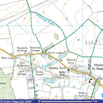 Footpath 7 starts at about 63 metres above sea level at the junction
of Bridleway 2 and Bridleway 3 where they cross Millbridge Brook north of
Hatley St George (TL 277517). It follows the eastern bank of the brook upstream
for about 300 metres where it then veers east. You can see the farm buildings
of Church Farm to the south. The path continues to follow the brook for a
further 500 metres until it meets Bridleway 4, Baulk Lane. A baulk was a
medieval term for a long narrow strip of land between the ridges of the open
field system that allowed farmers and peasants to get to their fields. This
lane takes you south into Hatley St George or northeast towards Hayley Wood and
Longstowe.
Footpath 7 starts at about 63 metres above sea level at the junction
of Bridleway 2 and Bridleway 3 where they cross Millbridge Brook north of
Hatley St George (TL 277517). It follows the eastern bank of the brook upstream
for about 300 metres where it then veers east. You can see the farm buildings
of Church Farm to the south. The path continues to follow the brook for a
further 500 metres until it meets Bridleway 4, Baulk Lane. A baulk was a
medieval term for a long narrow strip of land between the ridges of the open
field system that allowed farmers and peasants to get to their fields. This
lane takes you south into Hatley St George or northeast towards Hayley Wood and
Longstowe.
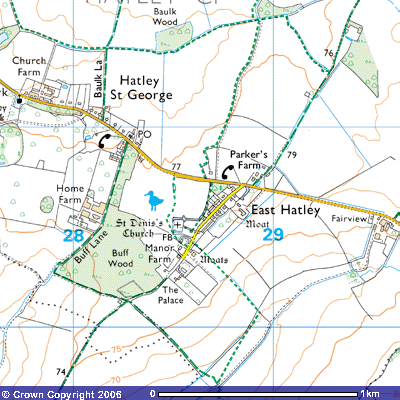
After
crossing the footbridge (TL 282514) the footpath continues east along the
southern side of the brook for about 300 metres when it passes Baulk Wood (TL
285515). It then veers east-northeast following the brook for a further 500
metres until it meets the junction of Bridleway 17 and Footpath 9. Bridleway 19
takes you north towards Hayley Wood and Longstowe and Footpath 9 takes you
south down an ancient track back into East Hatley. Footpath 7 continues for
about 200 metres past the south side of a small plantation before leaving the
brook and turning southeast for a further 500 metres until it meets Bridleway 18 (TL 293513). This ancient
track takes you south-southwest into East Hatley or north-northeast along
Croydon Old Lane towards Longstowe and Kingston.
Back
to map