Footpath
8
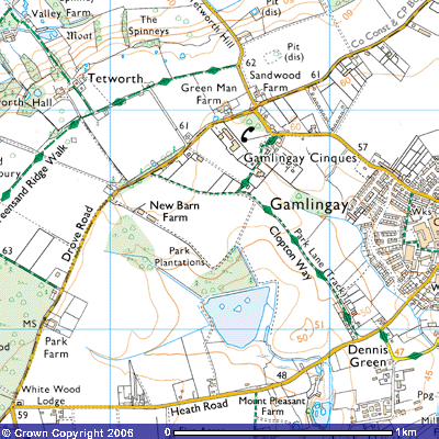
Distance 1.3 km. Direction SE – NW.
![]()
![]()
![]()
![]()
![]()
![]()
![]()
![]() This footpath, marked Park
Lane on the OS map, is part of the 17 km. long Clopton Way, a recently
designated footpath from Wimpole Hall, near Cambridge, to Gamlingay. It was
part of a much older east-west route way system from Gamlingay to Gamlingay
Cinques, Tetworth, and then down the Greensand Ridge, across the Roman Road
northwest to the Great North Road at St Neots or west to the confluence of the
River Ivel and the Great Ouse at Tempsford. It might have been called Clopton
Way as the route passed through the deserted medieval village of Clopton, just
west of Croydon, near Wimpole. However, Thomas Langdon’s map of Gamlingay drawn
up in 1601, shows a field to the east of Park Lane named Cloptons. Maybe the
Clopton family had farmed the field west of the brook in the 16th
century.
This footpath, marked Park
Lane on the OS map, is part of the 17 km. long Clopton Way, a recently
designated footpath from Wimpole Hall, near Cambridge, to Gamlingay. It was
part of a much older east-west route way system from Gamlingay to Gamlingay
Cinques, Tetworth, and then down the Greensand Ridge, across the Roman Road
northwest to the Great North Road at St Neots or west to the confluence of the
River Ivel and the Great Ouse at Tempsford. It might have been called Clopton
Way as the route passed through the deserted medieval village of Clopton, just
west of Croydon, near Wimpole. However, Thomas Langdon’s map of Gamlingay drawn
up in 1601, shows a field to the east of Park Lane named Cloptons. Maybe the
Clopton family had farmed the field west of the brook in the 16th
century.
A large
unpolished greenstone axe was unearthed in one of the gardens on Park Lane (SMR
08874; TL23085108). It was 8¾ inches long, 3½ inches wide and thought to be
from the Neolithic period, 4,000 BC – 2201 BC. It was probably used to cut down
trees for firewood, building purposes, making tool handles and killing animals.
The start
of the public bridleway is about 200 metres out of the village when you leave
Green End west up Heath Road. You pass a small cluster of 19th
century houses on the top of a slight rise known as Dennis Green. It was named
after the Dennis family, 19th century landowners. In 1873, Captain
William Warner Dennis, Deputy Lieutenant and Justice of the Peace, lived at
Little Heath, the small settlement down the track to the south. In 1874 he
owned one of the village’s brick and tile works. Another William Dennis lived
at Merton Grange, one of the medieval manors owned by Merton College, Oxford.
During the
time of the brickworks The Fountains public house was built. It has now been
converted to a dwelling. The hamlet stands on the top of a slight rise, about
50 metres above sea level, about a kilometre northeast of the medieval hamlet
of Newton on the Heath. There were houses, outbuildings and fields recorded in
1230 AD that had disappeared by 1279 (SMR 02382; TL 22005100). The cultivated
land reverted to heath and common land. The half-timbered house on the opposite
side of the road is believed to date from 1621.
Both Park
Lane and The Clopton Way are signposted about 100 metres further west (TL
231519). An unmetalled track on the northern side of Heath Road passes a
late-20th century bungalow appropriately called Heathview Cottage.
On either side of the track you will see several similarly aged bungalows named
Fountains and Cheveley which have stables and paddocks. After about 200 metres,
after the entrance to some stables behind a huge conifer hedge, there is a gap
on the eastern side leading into a field of pasture (TL 230522). This forms
part of the dog run, a popular path used by local dog owners from the housing
estates in Fair Field, Green End and Greenacres. On the 1601 map it was called
Broome Close and owned by Mrs Brudnell. After a few hundred metres the farm
track narrows to form a footpath running roughly north-northwest alongside a
mature hedge of hawthorn, oak, crab apple and bramble.
In wet
weather it can be quite muddy so good walking shoes are recommended. Looking on
both sides of the path you can spot that you are walking up a gentle ridge. The
underlying rock is the Lower Cambridgeshire Greensand, which started to be
deposited between 96 and 94 million years ago. At the bottom of the shallow
valleys to the east and west, the Greensand has been eroded to expose the much
older Ampthill Clay, laid down from about 150 million years ago. This erosion
was caused during a series of ice ages, some of which covered much of southern
Britain. The overlying strata of Upper Cambridgeshire Greensand and Chalk were
scraped away during the last ice age which only melted about 11,000 years ago.
Over the barbed wire fence to the east you can see the Greenacres housing
estate across the fields. This is Cloptons field. To the west you can get
glimpses through the hedge of Gamlingay Old Park.
The
estate is known today as Gamlingay Old Park and Park Lane is one of the few
remaining indications of the Downing property. The story of George Downing and
his descendants can be found in Bernard O’Connor’s booklet Gamlingay Park and the Downings in the library. Folow these links
for details of various members of the Downing family.
George Downing I (1624 – 1684) the English
diplomat, spy, baronet and builder of Downing Street, London
George Downing II (1656 – 1711) and
Gamlingay Park
George
Downing III (c.1684/5 – c.1747/9)
and Gamlingay Park
George Downing III and the
rotten borough of Dunwich
Jacob Garret Downing, the demolition of
Gamlingay Park and setting up of Downing College, Cambridge
Jacob Garret Downing, Lady
Margaret Downing and the Rotten Borough of Dunwich
Gamlingay
Park was purchased by George Downing I in the late 17th century from
Sir John Burgoyne of Potton. It was his son, George Downing II who started the
construction of a mansion and George Downing III who finished it by 1712. Part
of George Downing I’s will of 1717 was that, should his descendants die without
a male heir, the estate was to be used to set up a college in Cambridge. When
Sir Jacob Downing died with out a male heir, his wife, Lady Margaret Downing,
contested the will and, in an attempt to stop the estate being given to
Cambridge University, she had Gamlingay Park mansion demolished and sold off.
Details of the house and gardens are found in George Downing III’s account
referred to above.
Part
of Park Farm (217520) on Drove Road, dates back to the early-18th
century and its early tenants probably produced much of the food for the
Downings and their guests. Records show it was originally called Adams Farm. It comprised
of just over 107 acres in 1752, 95 acres of which were arable and farmed in the
traditional three-field system.
It was
later known as Manton’s, Holken’s, Job’s and the Street Farm. Downing College
enlarged the Park in 1818 to 233 acres, by which time the farm was called Park
Farm.
On
the roadside beside the farm was a milestone with a pyramidal top. On it is inscribed
“50 miles from London the Six Miles Stone from ye 44 Mile Stone in Baldock
Lane to this Place was set up by Rog Burgoyne Bart in 17??. The last two
numbers have been weathered but it is thought to be 1751 when the Bury (Hunts.) and Stratton Park (Beds.)
Turnpike Trust was established. Sir Roger Burgoyne died in 1780. (SMR 02384)
You
can catch glimpses of the lake through gaps in the hedge on the western side of
Park Lane. Scrub and rough grassland gives way to copses of trees in which
are said to be traces of the extensive gardens. The lake was recreated in the
20th century and now attracts enormous flocks of geese in the
autumn, resting there before migrating south for winter. Fowler
commented that
“the only indications of the site of the mansion are the cellars
underlying the mould, and the only brickwork that has resisted the ravages of
time is the curious “O” or moon, situated near the Cinques hamlet. This pile of
brickwork, which is very massive, has been the cause of much conjecture and
argument. Fifty years ago (1885) the circle was perfect, but now the top
has fallen in, and the only portions left are in the form of two upright piers
of brickwork. It is believed that more than one piece of brickwork was erected
upon the estate by the eccentric Downing. The fact that the circle alone can
now be seen need not to infer that it was the only erection. Circular work has
a curious property - that of binding itself together with age. The theory is
that the last wall of the estate, of which this is a portion, contained the
word Downing. The local tradition, handed down through the years, is that Sir
George Downing built a high wall on the eastern boundary. The letters of his
name, “Downing,” were inserted into this wall, and the intervening spaces
filled with glass. Also that Dick Turpin, on his memorable ride from London to
York, being closely pursued by the myrmidons of the law, jumped through the “O”
upon Bonnie Black Bess in reckless bravado, scattering the glass in every
direction.”
(Fowler,
E.J. (1935), History of Gamlingay and Neighbourhood, Fowler Bros.
Gamlingay, p.8)
The
Turpin connection is considered to be a fable. Fowler also suggested that Sir
John Jacob Knight, the owner of Woodbury Hall in the reign of Charles I, had
the wall built to commemorate his centenary and that it contained the number
“100.” The Moon Gate was one of the 0s. It was a local landmark until early in
the 20th century when it eventually collapsed.
The
major landmark today when you look west is the 1000kW TV transmitter at Sandy Heath (TL
204494). An engineer at the base told me that on 13th July 1965 it first
rebroadcast signals received directly from Mendlesham in Suffolk, at 30kW
towards Bedfordshire. On 18th January 1971 its 625-line transmitter began
transmitting BBC 1 and Anglia Television. It now transmits for independent television and radio companies over an area north of the
Thames to Peterborough. As Ultra High Frequency radio waves only travel within
line of sight plus a further 10%, a 277.5 metre (750ft) high mast is needed.
The huge white cylinder on the top of the mast now transmits analogue
services for BBC1, BBC2, ITV1, Channel 4, Channel 5 and digital services Mux1,
Mux2, MuxA, MuxB, MuxC and MuxD. Each multiplex can carry up to six television
services in the same bandwidth as one analogue service. Attached to the mast
are also white egg-box constructions, which are transmitters for local and
national analogue radio, and more recently DAB digital radio. Space is also
rented out to other users like BT, Vodaphone and Orange. An extension to the top
means it is now 290 metres high.
The earlier
landmarks were church towers, spires or old oak trees. There are dozens of oak
trees along the path, some of which might well have been planted as part of the
Park’s southern boundary. There are also huge numbers of crab apple trees. Crab
apple jam and crab apple jelly were popular conserves you could make from the
hedgerows. Few people collect them today and in late autumn the ground is
littered with thousands of little yellow apples, which then turn brown and
decompose. You can also pick brambles or blackberries from the bushes along the
path.
Changes in farming practices have meant that
many of the fields alongside the path have been left fallow. The Park is slowly
reverting to woodland. You can see numerous bushes and small trees growing up
in the long grass. The fields on the eastern side tend to be cut for hay –
fodder for the numerous horses kept in nearby paddocks. Depending on the time
of year, in some places you can see the yellow flowers of the gorse, which
originally covered the heath.
Shortly
after passing some paddocks on the eastern side of the fence, a stand of silver
birch trees forms the edge of a property on the Clopton Way. Once past it there
is a choice of routes. A grassy path veers off northeast into Gamlingay
Cinques, sometimes written as Gamlingay Sinks (TL226526). You can walk through
the Nature reserve back onto Drove Road and come back down Footpath 8 to the
same spot.
A
small yellow arrow on a fence post highlights the route of Footpath 8. It
continues on the southern side of the field boundary for about 400 metres
westwards towards Drove Road. After the field has been ploughed the sand and
clayey soil is a dramatic brown colour. Aerial photographs of the fields to the
south, near new Barn Farm, show a ridge and furrow pattern, the medieval field
system where peasants farmed a long, narrow strip of land earthed up into a
ridge. The furrow was the dip between each farmed strip and was used for access
and natural drainage. In some places are baulks, raised earth banks, one foot
wide and six inches high, on either side of the furrow, often made with stones
picked from the fields (SMR 11394, 2304
TL 22155265). To the north, aerial photographs indicate some rectangular
earthworks around an oval hollow, damaged by a sand pit on its northern
boundary. Their date is unknown but they appear to be old field boundaries.
(SMR 09969; TL 2265170)
Footpath 8
finishes on Drove Road about 100 metres northeast of the estate road leading to
Tetworth Hall, about 500 metres southwest of Gamlingay Cinques. (TL 222527)
Following the road you pass a number of smallholdings and then ARMFIBRE, a
factory making reinforced plastic products for pollution control. Immediately
past it is a kissing gate giving access to Cinques Common Nature reserve.
Extensive
tree planting, pig rearing and market gardening following enclosure have
altered the natural vegetation of the Heath. The Wildlife Trusts have set up
this nature reserve at Gamlingay Great Heath and are reintroducing heath land
to help conserve some of the natural habitat. Sheep grazing is to be
reintroduced. The reserve includes a pit dug for the Cambridgeshire Greensand
needed in the construction industry. When the pits were first excavated is
uncertain but thought to be after 1844 Enclosure Act. Other overgrown pits or
hollows that dot the fields along the top of the Greensand Ridge in this area
are remnants of this old industry. In wet weather, you can see pools of water
where rainwater has not yet managed to drain into the Gault Clay beneath.
Naturalists
have been attracted to these heath lands for centuries. John Ray, often
referred to as the father of English natural history, described plants on
Gamlingay Heath in his Catalogue of Cambridge Plants published in 1660.
The reserve contains a variety of habitats unique to Cambridgeshire, from
wetland plants in the damp hollows to heath and woodland on the dry acidic
Greensand. Over the years, 22 different plant species have been found. When one is walking through
the countryside one of the measures used to determine how old a path or
trackway is, is to count the number of species and multiply by 100. This gives
2,200 years for Gamlingay Cinques, a reasonable date for when the trees might
have started being cut down. On the wetter soils you can find St. John’s
wort, cuckooflower, bent grass, sedges and rushes. On the drier soils there are
heathers, heath bedstraw, harebell and heath grass. There is also gorse and
areas of maturing woodland .including pollarded oaks, cut off at shoulder
height to stimulate new straight growth above the heads of grazing cattle.
Once you
reach the car park at the edge of the nature reserve you have a choice of
routes. Following the road through the predominantly 19th century
cottages takes you down Cinques Road, mostly along the pavement back into
Gamlingay. An alternative route is to cross the eastern edge of the common
towards the slate-roofed Victorian cottages where a farm track takes you back
to Footpath 8.
The
settlement of Gamlingay Cinques is old. A 17th century thatched
cottage can be seen From late spring to late autumn one can often hear the
honking of geese around Gamlingay. The reason is that Gamlingay offers ideal
habitat for greylag and Canada Geese, particularly the lakes in Little Heath
and in Gamlingay Park. The greylag (Anser
anser) is the ancestor of most domestic geese and
the largest and bulkiest of the feral geese native to the UK and Europe. Its
wingspan can reach 175 cm. and its length 100 cm. Its name derives from its
pale grey neck, chest, belly, wings and rump and that it is often the last of
the geese to fly north during the breeding season, lagging behind the others.
You may have seen great flocks of them flying over in their typical v-shaped
formation. Their habitat tends to be low-lying grassy fields in river valleys
where they forage on grass, roots, cereal leaves and spilled grain. Its voice
is a loud cackling call as opposed to the deep honking of the
Canada goose (Branta canadensis). Both make loud hissing sounds when
threatened and can be aggressive when protecting their young.
The Canada goose is the only other feral goose seen in Britain throughout the year,
and the only one, apart from the greylag, to breed here It was
recorded in the gardens of Palace of Versailles, outside Paris, during the
late-17th and early-18th century, brought back to Europe
by French explorers and naturalists. The earliest reference to them in England was
during the reign of Charles II in St James’s Park. It was probably here, or at
Versailles, where George Downing got the idea of introducing them as ornamental
birds to his new lake and ponds in Gamlingay Park. They were considered in 1785
to be “a great ornament to the pieces of water in many gentleman’s seats,
where they are very familiar and breed freely.”
Now, it is the most familiar goose in Britain. It has a long black neck and a black head with a prominent white
patch, which forms a strap around the throat that extends onto the face. Its
body is brown, with paler underbody. Its length is over 91 cm. Its bill is
black and legs are olive green. Like
the greylag, its habitat is open grassland and marshes with lakes and ponds,
especially those in parks or surrounded by mature woodland. Like the greylag
geese they feed
on grass, water plants, sprouting corn and in autumn, gleanings from the fields
of arable stubble. They nest, sometimes in large colonies of several
hundred, between late-March and mid-May, almost invariably near water and
frequently on an island, in some well-sheltered and low-lying place away from
foxes.
To get back
into Gamlingay from Gamlingay Cinques you can walk down Cinques Road. An
alternative route is to follow the footpath across the common in Gamlingay
Cinques signs back down Park Lane towards Green End.