Footpath
9 (Everton), Footpath 11 and Footpath 4 (Tempsford)
Distance:
c.110m. 1,200m. and 800m. Direction: NW, WNW and N
54 53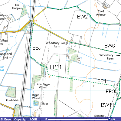
Until World War Two, this was part of the
main route between Everton and Tempsford railway station. When the Airfield was
planned in 1939, the Air Ministry got permission to close the paths and
bridleways across the base. Footpath 9 starts about 100 metres north of where
the main runway crosses the Roman Road (TL 194529). This NE – SW runway allowed
planes to take off directly into the prevailing southwesterly winds. On average
the wind blows from the southwest for 200 days of the year. The path is only
about 110 metres in length because it ends where it crosses the parish boundary
with Tempsford.
In
2006 there were revisions made to Footpath 9 and Footpath 11. As they were so
little used, it was difficult to determine the exact route. According to the
map, it follows the eastern side of Roman Copse, a newly planted area of mixed
woodland, and then goes through it to become Footpath 11 on the other side (TL
194530). However, it is not signposted.
A wide swathe around the western and northern edge of the plantation has
been cut, which, if followed, leads you to a gap in the hawthorn hedge. This
opens onto a concrete turning circle at the end of what was an E – W
runway.
Footpath
11 followed this overgrown concrete track about 1000 metres westwards. The new
footpath will follow the south side of the hedge from the Roman Road, Bridleway
11 (195532). During the war you would have seen buildings for storing bombs,
incendiaries, fuses, parachutes and the special canisters packed with supplies
for the resistance groups in occupied Europe. Almost all of these buildings
were dismantled and removed after the war and much of the concrete removed to
restore the land to agricultural use. Through gaps in the hedge to the north
you can still see some of the remaining low, flat-topped sheds. The path ought
to pass through the northern end of Dick’s Wood (TL 187532) but it is so
overgrown that you have to go round the eastern side until you reach the hedge.
You might see several pigs behind an electrified fence, grubbing around in the
earth amongst hawthorn bushes near a small pond (TL 186533). It is marked on
the map as “sinks”, into which the drainwater soaks into the soil rather than
feed into the main drainage system. After a spell of dry weather, often during
the summer, you can see how the bare earth has been cracked wide open as the
clay dries out. Some cracks can be over two centimetres wide.
The
path marked on the map passes though Dick’s Wood and continues west for about
400 metres towards the electricity pylon (183533) before turning north for
about 200 metres to become Footpath 4 at the edge of Little Biggin Wood. If you
followed the path to north it continues WNW until it becomes a concrete track.
By the side of it you might see where rainwater has washed away the soil to
reveal its foundations. London Brick Company ‘Phorpres’ bricks were some of
those brought in from London, Peterborough and other cities bombed during the
Blitz to be used as hardcore for the roads and runways. After about 300 metres
you pass underneath the electricity transmission line which runs parallel to
the N — S runway (TL 183533). in front of Little Biggin Wood. The now gas-fired
Little Barford Power Station is only a few kilometers to the north. You might
be able to pick out the two white cooling towers on the northern horizon.
Before you pass through the oak and ash woodland you can see a concreted area
to the north where disused agricultural machinery, a few old cars and piles of
concrete and other waste have been stored.
About
500 metres to the south, not on the footpath, is Biggin Wood, within which is a
medieval moat (TL 182527). Along with White Wood on top of the Greensand Ridge
to the east, it is thought to be one of the few remaining ancient woodlands to
survive in this area. The rest have been deforested to provide firewood,
charcoal, building material, weapons, tool handles and farmland, The moat is
about 5 m. wide and a Norman manor house would have stood on the interior
platform which is about 1,000m2. Nothing remains of the house. The
manor of Everton Biggin was absorbed into Everton Manor in the 17th
century.
The
start of Footpath 4 is about 18 metres above sea level. During the war there
were two camouflaged blister hangars beside the railway line, housing the
Stirling, Halifax, Lysander or other planes used at the airfield. Although the
site of Little Biggin Wood may be ancient, the trees themselves date from
Victorian times. The densely packed trees make it very dark and gloomy. The
bluebells are a sign of ancient woodland but the common plants in the
undergrowth are cleavers and common nettles. Those walkers with binoculars
might spot a Reed Bunting in the wood, Buzzards and sparrowhawks might be seen
flying overhead. A day-flying Mother Shipton moth was spotted in June 2004, named for its
similarity to the old woman of Shipton cave in North Yorkshire. Within
the wood you can see laid out in the undergrowth, dozens of concrete pipes.
Once you have passed through the wood, the path continues northwest along the
north side of a hawthorn hedge towards the London and Great North Eastern
Railway. You will have heard some of the trains pass by on their way south to
London or north to Peterborough and beyond. Before 1850 when the railway was
built, the path continued northwestwards to Jesus College Farm (TL 175538) in
Tempsford. You pass underneath a telegraph line that runs parallel to the
railway line. Just before the path reaches the railway line, a farm track to
the south crosses one of the specially built wartime bridges. Instead of the
normal brick arch you can see a solid concrete one to take the weight of heavy
military trucks. "Restored
11.7.54 B. Sims & Son" is inscribed on it. The
path then runs north for about 500 metres alongside about a 4-metre deep
drainage ditch to Tempsford level crossing. Sedge warblers and whitethroats can be seen
flitting around looking for food. The ditch is abundant
with vegetation caused by eutrophication, the run off of nitrates and
phosphates after almost a century and a half of using chemical fertilizers.
Crops like wheat and barley grown in the adjoining fields need significant
quantities but rainwater infiltrating the soil leaves a residue in the
groundwater which ends up in the drainage channels.
At
the end of the path you can see a white post indicating the presence of an
underground oil pipeline (TL 180542). There is a tunnel underneath the railway
embankment, which takes the water from the drainage channels west towards the
River Ivel. A male grey
wagtail was seen singing by the pond in front of it. The
road running to the east goes to Woodbury Lodge and the start of Bridleway 6
which takes you to Woodbury Low Farm and the Roman Road. You may well have
heard a warning siren as you approached the railway. This and the flashing red
lights indicate that the gates of the level crossing are about to close.
Bridleway 2, about 400 metres north up the road alongside the railway, takes
you northeast past Cold Arbour Farm and then east back towards the Roman Road.