The
History of Hatley
(O.S. 6 ins. TL 24 N.E., TL 35 S.W., TL 24 S.E.)
Royal Commission of Historical Monuments (1968),
Inventory, Vol. 1.
The civil parish of Hatley, 2255 acres, was formed in 1956 by uniting
Hatley St George (alias Hungry Hatley) and the slightly larger
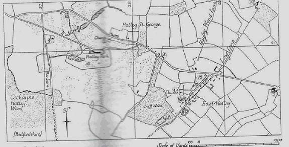
Hatley St George, a single manor, belonged to the St George family at
least from Henry III’s time, and was then probably already emparked.
The village today consists of a few estate dwellings, mostly 19th
century, ranged along the modern road from Gamlingay to Croydon which cuts
across the old lines of communication but which now provides the sole access
for vehicles. No earlier village site has been identified.
The Hatleys, together with adjoining parts of Croydon, include the
highest ground in
ECCLESIASTICAL
1.
Architectural Description – The W. extremity of
the N. wall of the chancel is old and retains a blocked square-headed
‘low-side’ window with a chamfered surround (grooved, fluted edges). The
chancel arch has been rebuilt but some dressings have been reused, including
the moulded caps to both responds (A pilaster or half-pier engaged to a wall
and carrying one end of an arch or groin, often at the end of an arcade) of c.
1300.
The nave
(45 ½ ft. by 21 ft.) is probably of c. 1300, although some of the openings look
a little later. There are three windows in the N. wall; the first of two trefoiled (three leaves) lights with a quatrefoil (four
leaves) in the head, is restored and has modern splays (An oblique angle or
bevel given to the sides of an opening in a wall so that the opening is wider
on one side of the wall than on the other) and rear arch; the second and third,
both somewhat restored, are lancets (an acutely pointed Gothic arch, like a
lance), the second with a cinquefoil (five leaves), the third with a trefoiled head. The three windows on the S. side resemble
those corresponding to them on the N. and are somewhat restored; the W. window
resembles the middle windows of both side walls and is set between restored
buttresses rising to the rebuilt bellcote. The N.
doorway is of two continuous chamfered orders; the mid-14th century
S. doorway is of two continuous wave-moulded orders separated by a three-quarter
hollow. The nave roof is modern.
Fittings
–
(2) PARISH CHURCH OF ST GEORGE, Hatley St
George, straddles the N. and S. oblong churchyard which is bounded by a bank on
the N., towards the road, and by a substantial ditch on the other sides, except
at the N. end of the E. side where the churchyard has been enlarged. The fabric
consists of a chancel with N. and S. adjuncts, rebuilt 1873-8; aisleless and porchless Nave;
and West Tower, with N. vestry
also of 1873-8. The walls of the nave
and tower, which are plastered, are probably of field stones and rubble as are
those of the rebuilt chancel; dressings where original are of clunch; the roofs are tiled.
The Lysons (Cambridgeshire 210) say the church was
built in 1352, but without citing authority; the earliest identifiable
features, the N. and S. doors of the nave, look somewhat later. The church, or
what now remains of it, was refenestrated (new
windows put in) in the 15th century. The top stage of the tower was
extensively repaired in red brick in 1625.
Architectural Description – The tall and
narrow chancel arch is of two chamfered orders (grooved, fluted vertical
pillars), the outer continuous, the inner with modern or restored moulded caps and bases, and may be of 14th
century origin.
The Nave
(39 ¾ ft. by 20 ½ ft.) has two 15th century windows in each side
wall, all of three cinquefoil lights (five openings in the shape of leaves)
with vertical tracery in a four-centred head,
restored, those on the S. side more or less completely. The N. doorway, of the
second half of the 14th century, has restored moulded
stops; the S. doorway has continuously moulded jambs
(vertical post or column) and is coeval (from the same period). The S. nave
buttresses have been restored in the 17th or 18th
centuries; those on the N., more recently.
The West
Tower (8 ft. by 8 ft.), late-14th or 15th century, is
divided by strings into three stages, with three-tier diagonal W. buttresses
and N. and S. angle buttresses of similar style at the E. corners, reaching to
the base of the top stage. The W. window is of two cinquefoil lights with
vertical tracery in a four-centred head. The second
stage has a decayed trefoil-headed lancet (three sharp-pointed openings) in
each free face (wall). The top stage, much of which has been repaired in brick,
has large blocked arched windows in each face with a smaller two-light window
in each blocking; the embattled parapet (like the battlements on a castle wall),
also of brick, has original gargoyles to N. W. and S. The date ‘1625’ incised
in the plaster rendering of the blocking of the N. belfry window is now
scarcely legible. The tower arch is of three continuous orders to the E., the
middle order being moulded, the others chamfered; to
the W. it is of a single chamfered order.
The roofs are modern but that of the nave
rises off eight 14th or 15th century moulded
part-octagonal corbels (eight-sided projecting stones) with supporting carved
heads or half figures.
Fittings – Bells: two; 1st dated 1682; 2nd, 1662; both
by Toble Norris, with shields of arms of Cotton
quartering Bruce and inscriptions recording
gift respectively by Sir Robert and Sir Thomas Cotton. On wheel spokes of
the 1st are inscribed the initials ‘SL’ and GL’; on those of the
second are ‘IS CW’, ‘1798’.
SECULAR
(3)
The House,
two-storeyed, partly with cellars and attics, of
local red brick (from Gamlingay brickworks?) with roofs of Westmorland and
other slate, is the product of at least three building phases, not counting
changes within the last hundred years. Though predominantly an 18th
century structure it incorporates a 17th century nucleus John Layer
in his History of Cambridgeshire
(C.A.S. 8vo. Publs.
liii, (1933), 106) remarks ‘the ancient seat is decaied and a pretty gentlemanlike seate
now there built’. Attached to the 1601 maps of Gamlingay, by T. Langdon, at
Merton College, Oxford, is a comparatively crudely drawn supplement showing the
W. part of Hatley and depicting ‘Mr St Georg his house’ apparently in the position of Park Farm
(Monument (4)). Layer’s words imply recent rebuilding on a fresh site and
this is most likely to have been done by Sir Henry St George, garter King of
Arms, between his father’s death in 1635 and Layer’s own demise in January
1641. an engraving by Johannes Kip (Britannia
Illustrata (1707), Plate 58) purports to show the
house as it was after a rebuilding attributed to the Lysons (Cambridgeshire,
210) to Sir Robert Cotton (of the Connington
Cottons), who came into the property while still a minor (under 21), perhaps as
early as 1682 (See PARISH CHURCH OF ST GEORGE, Monument (2), Bells). After Sir Robert Cotton’s death
in 1749 the property passed by a series of marriages to Margaret Cotton (of the
Madingley family); she had already enlarged the house
by 1753 (E. Carter, Cambridgeshire,
(1753), 199), adding wings on either side of the house as left by her
predecessor, although the wings as they now stand may not have been completed
until after that date. During the second half of the century the house belonged
to the Pearse family; a Mr. Pearse
was offering the materials of the house for sale in 1782 (Cambridge Chronicle, 16 Nov. 1782); it was purchased by Thomas Quintin but was not demolished, although it may have then
been stripped of its fittings. The Quintins may have
refaced part or all of the N. front.
The house was again enlarged and lavishly
refitted in reproduction Georgian style late in the 19th or early in
the present century. Some genuine 18th-century chimney pieces and
other embellishments have also been imported within the last hundred years.
Modern additions at the E. and W. ends have recently been demolished
(pre-1977).
The N. or principal elevation is in
thirteen bays with late 18th or 19th-century sash windows
on both floors; seven bays are those of the middle block, being Sir Robert
Cotton’s house of c. 1700; the remaining six, three and three, are those of the
wings added c. 1750. The uniformity of the brickwork may be attributable to
re-facing of the middle block about the time that the wings were added. The
middle block consists of a three-bay centre piece and side pieces of two bays
each and has a stone cornice and parapet with stone coping (slanted bricks to
all rain run-off); this parapet is broken by a central pediment framing a small
round window. The quoins of the centre and side pieces, as well as those of the
wings, are of rusticated stone; the front is embellished with six stone urns.
The central front door is modern, the Palladian windows in the middle of the
ground floor of the wings are 18th century but appear to have been
improved.
The S. elevation is irregular, owing to the
incorporation of the original 17th century house. This is reflected
by five closely spaced bays occupying most of the middle block, which are
supplemented by two bays towards its east end; these and the uniform red-brick
facing of the middle block on this side are of c. 1700. For the rest, the
elevation is symmetrical, with a stone-capped parapet extending its entire
length surmounted by six stone urns. The side pieces, apparently a somewhat
later elaboration of the mid 18th century wings of the N. front,
were at first built with two bays, each deeply recesses, and the third, at the
ends, breaking forward again as turriform projections (in the shape of turrets); but
the effect has been weakened by modern ground-floor infilling with flat roof
and cast-iron balustrade, the last perhaps reused. All the windows on the S.
side are late 18th or 19th-century sashes with stucco
(durable, exterior wall coating of cement, sand and lime) surrounds except for
three dormers in the centre block. Two rainwater heads of the late 18th
century survive. The glazed and pedimented (stones at
base) doors at either end are modern.
The inside of the house has been rearranged
and is almost devoid of original features, but some paneled doors and shutters,
also one or two wooden fireplace surrounds in the attics, are old.
Irregularities in the modern plaster ceiling of the drawing rooms probably
result from the removal of a through passage bisecting the original house. The growth of the house may also be reflected
in the irregular lay-out of the cellars. The roof of the middle block, which is
hipped and rises to a central valley, is framed with staggered purlins (horizontal timbers supporting the rafters); its
members, partly of oak and partly of softwood are of variable scantling
(upright in house frame); the oak may well be reused timber from the roof of
the original house (at Park Farm, now the Dower House).
W. of the house
predominantly modern. Service Buildings include three or four
of those illustrated by Kip, all in red brick of c.1700 but much altered. The
most considerable of these fronts to the N. and retains most of its
symmetrically disposed windows with flat arches and a central doorway with
rusticated quoins (roughly finished, unsophisticated, exterior corner stones)
and head in stuccoed brick. The Grounds include gardens on the N. bearing no relation to those
delineated by Kip; these are diversified by adventitious statuary and urnage in marble, freestone and composition of the 17th
to 19th centuries. The large and pleasant park seems to have been
created about the middle of the 19th century.
(4) PARK FARM, 80 yds.
E. of Bar Lane, L-shaped, two-storeyed, framed, with
tiled roof, though considerably altered and with modern infilling in the angle,
is probably of 16th century origin; it may have been the house of
the manor of the St George family, the seat of which was transferred to its
present site c. 1635 (see Monument (3)).
The main N. and S. range has been cased in
modern brick and has two added window bays on the E. side and one at either
end. The W. part of the long E. and W. wing, which is plastered, was originally
lower than the rest and open to the roof, but has been heightened. Over the
rest of the house the roof, largely original though of rough construction, is
based on tie-beam and collar trusses; two plain cambered tie beams are partly
exposed in the E. part of the wing.
The S. ground-floor room of the main range
is lined with 17th century run-through paneling, for the most part in situ, including a length of frieze
with incised fan ornament; from the arrangement of the paneling a door in the
centre of the N. wall of the room and another opening in the S. wall can be
inferred. This room has a chamfered brick fireplace surround with segmental
head, also 17th century.
(5) THE GEORGE, beer house, two-storeyed, of red-brick with white brick dressings and tiled
roof, is designed as a main range with N.W. cross wing. The main range has a
slightly projecting chimney S.W. to the street with stone panel having the
initials and date ‘TSQ 1850’ (Thomas St Quintin?) on
a shield; either side of the stack on the ground floor are small tiled oriels (A bay window projecting from an upper floor, supported
from below with a corbel or bracket.) rising off moulded corbels; the gable of
the cross wing has an ornamental barge board and beneath is a third oriel.
(6) MANOR FARM (Class U), two-storeyed, of stuccoed brick with
hipped slated roof, stands on the moated site
(Monument (16)) of the manor house of the Castell family, demolished c. 1685.
The house, ostensibly 19th century, incorporates earlier work, the
bulk perhaps of the 17th century, but including an 18th
century stair, the balusters of which are cased (It was replaced by 2005 with
21st century oak); also most of a small 15th or early 16th-century
tie-beam truss comprising a stop-chamfered and cambered tie-beam with the
sawn-off tenons (A projection on the end of a piece of wood shaped for insertion into a
mortise to make a joint.) of some ceiling joists, two solid braces and the
stop-chamfered swell heads (?) of two supporting posts.
(7) HOUSES, a pair, two-storeyed,
of white brick with hipped thatched roof and a shared central chimney; the N.E.
house retains some of its original windows with leaded lights in Gothic idiom;
first half of 19th century.
(8) HOUSES, a pair, two-storeyed,
of white brick, roof covered with modern pantiles,
now one dwelling; the design approximates to Class J; first half of 19th
century.
(9) CARTER’S FARM, L-shaped, two-storeyed, of white brick with hipped and slated roof; c.
1840. the N.E., front elevation has
five sash windows and a central front door with latticed fanlight. The lower
rear wing houses offices.
(10)
LONG LANE FARM (Class J), two-storeyed, framed and
plastered, with hipped slated roof, is 18th century. The traditional
design is elaborated to include a narrow staircase by at the S. end and an outshut of indefinite extent on the E; an early 19th
century addition now occupies the S. end of this side.
(11)
BRICK KILN (N.G. TL 269521). The ‘brick kyll upon ye
Queen’s Land’ marked on the supplement to T. Langdon’s 1601 map of Gamlingay
(Merton College, Oxford) can still be traced by a scatter of briquetage (coarse ceramic material) of uncertain date.
(12)
HATLEY WILDS (Class J; N.G. TL 296524). of one storey
with attics, partly framed and plastered, partly of brick, with tiled roof
hipped at the S. end; inside some chamfered ceiling beans are exposed; first
half of the 18th century. (local stories
tell of there being a tunnel at Hatley Wilds leading to Longstowe
church.)
EARTHWORKS
(13)
GARDEN REMAINS (mostly on O.S. at
Other
earthworks in the park do not appear on the tithe map of 1839 and were presumably
made after that date. The most prominent are a bank along the S. side of the
road, 600 ft. long, 25 to 40 ft. wide and 2 ft. to 4 ft. high (possibly a
ha-ha), and an irregular mound (N.G. TL 27315140) 90 ft. across and 3 ft. high.
(14)
MOATED SITE (Class A 1(b); N.G. TL 28355020), not on
O.S.), at the S.E. corner of Buff Wood. The moat is trapezoidal,
260 ft. N.W. by 225 ft. N.E. by 294 ft. S.E. by 167 ft. S.W. the wet ditch is
20 ft. to 30 ft. wide, 3 ft. to 5 ft. deep and 15 ft. to 18 ft. across at the
bottom. On three sides are counterscarp banks 20 ft. to 30 ft. wide and 6 ins. To 3 ft. high. There is a
causeway 25 ft. wide in the S.E. side with cupped and slightly staggered ends
to the ditch on either side. The interior is irregular, with two slight ponds
near the E. angle; the whole site is thickly overgrown.
(15)
MOATED SITE (Class A1 (a); N.G. TL 285503), immediately N.E. of The Palace on
the S.E. side of
(16)
MOATED SITE (Class A1 (a); N.G. TL 285504), at Manor Farm (Monument 6), on
level boulder clay 260 ft. above O.D., being that of the manor house of the
Castell family demolished c. 1685 by the second Sir George Downing (Lysons, Cambridgeshire, 201 and 209); the material
was later used at Gamlingay Park (see GAMLINGAY) (61), a rectangular area 200
ft. N.E. to S. W. by 100 ft. is partly enclosed by a wet ditch 32 ft. to 45 ft.
wide and 3 ½ ft. deep. This has been partly filled but still complete in 1750
(map in
(17)
MOUND (N.G. TL 28715059, not on O.S.), to N.W. of East Hatley village street,
on ground formerly part of the village green, now pasture; circular, 40 ft.
across and 2 ft. high; approached on the W. by a hollowed track 15 ft. wide and
about 6 ins. deep.
(18)
VILLAGE REMAINS at
It is
clear that the plan and road system of the village have been completely
changed, perhaps not long ago. (Before 1930 it is thought to
have run alongside the front of the mansion in Hatley Park but was moved north
to create lawns and parkland.) Remains of former house sites and of wet
ditches round their crofts, set back some distance from the present street,
indicate that the village formerly consisted of a triangular green with its
base towards the N., 50 yds. to
70 yds. beyond the modern
road, and its apex between the moats of The Palace and Manor Farm (Monuments 15
and 16). The green was presumably formed by the convergence of two roads, one
from the N.E., which can be traced as a disused track, known as Long Lane or
Croydon Old Lane, leaving Ermine Street at N.G. TL 31835355, and one from Longstowe in the N., called Hayley
Lane, now only a footpath. To the S.W. of the green the road led first S.W. and
then S. through the abandoned settlement of Pincote
(See Tadlow 9) to Tadlow. W. of the green are a number of possible house sites.
At N.G. TL 28605055, to the N.E. irregular scarps 9 ins. to 1 ft. high cover an
area 350 ft. N. to S. by 150 ft.; banks 30 ft. wide and 1 ft. high separate
them from ridge and furrow to the W. at N.G. TL 28605055, to the N.E. of the
church, is an area 400 ft. E. to W. by 250 ft. bounded on the S. by a wet
ditch, 30 ft. wide and 2 ½ ft. deep, which joins a stream on the E. A
projection N. from this ditch divides the area into two unequal parts. Recent
ploughing has turned up the footings of an 18th century brick wall
and of brick buildings, cobbles and 13th to 18th century
pottery. S.E. of the green are other ditched enclosures. That furthest to the
N.E., 230 ft. N.E. to S.W. by 90 ft. with ditches 15 ft. to 20 ft. wide and 1 ft. to 2
ft. deep, is cut by the modern road. Immediately S.W. of this are remains of
five or more similar enclosures, approximately 100 ft. to 120 ft. square. S.E.
of these, adjoining ridge and furrow, cobbles and pottery of the 11th
to 17th centuries occur; more irregular remains to the S.W. are
probably further building sites. Kinks in the hedge parallel to the S.E. side
of the green suggest long crofts behind the ditched building enclosures, later
destroyed and ploughed or reploughed into the
existing fields.
(19)
CULTIVATION REMAINS in the former parish of
(20)
CULTIVATION REMAINS in the former parish of Hatley St. George (not on O.S.).
Ridge and furrow survives over much of the former parish, especially in the
park. The remains are mostly curved with ridges 100 yds
to 270 yds. long, 5 yds. to 13 yds.
wide and 1 ft. to 1 ½ ft. high with headlands of 7 yds. to 12 yds.
In the N. of the parish around N.G. TL 283521 parts of three furlongs running
N.W. to S.E. and one running N.E. to S.W. (a complete furlong with 25 ridges),
all well preserved, are now combined in one field.
Around N.G. TL 276507 ridge and furrow running N.E. and S.W. is bounded by a
winding hollow-way 40 ft. wide, 1 ft. to 3 ft. deep and 25 ft. across the
bottom, perhaps an old route to Tadlow. To the E. of this are three small
blocks of ridge and furrow running N. to S. with an access way, 30 ft. wide and
9 ins. deep, running E. from the main hollow-way for 80 yds.
between the two blocks further N.
Traces
on air photographs complement these remains and much of the former open-field
pattern can be seen, with field boundaries fitting curving furlongs. The parish
was probably enclosed by the 17th century. (Ref: tithe map 1839
(T.R.C.); air photographs: 1060/UK/1635/1465-8; CPE/UK/2024/3020, 3060-3)