Permitted
Footpath Everton to Deepdale
Direction:
NW – SE Distance c.700m
PP PP
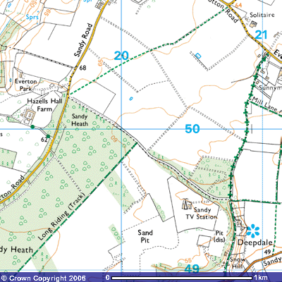 This is not a
public footpaths but the owners of the Everton Estate allow it to be used as a
permitted path. It starts at a small lay-by on Everton Road, about 700 metres
from the end of Everton village (TL 196503).
You will notice that a barrier and tree trunks have been put in place to
stop vehicular access. This was done in 2002 as a result of regular
fly-tipping, environmentally unfriendly abuse of the countryside. The 1,000
metre long track follows the line of the hedge in a long pine plantation across
Sandy Heath. It drops about 25 metres in this distance into Deepdale and
continues south into Potton.
This is not a
public footpaths but the owners of the Everton Estate allow it to be used as a
permitted path. It starts at a small lay-by on Everton Road, about 700 metres
from the end of Everton village (TL 196503).
You will notice that a barrier and tree trunks have been put in place to
stop vehicular access. This was done in 2002 as a result of regular
fly-tipping, environmentally unfriendly abuse of the countryside. The 1,000
metre long track follows the line of the hedge in a long pine plantation across
Sandy Heath. It drops about 25 metres in this distance into Deepdale and
continues south into Potton.
In
spring, carpets of bluebells obliterate the undergrowth. The Camdol
Tree Nursery can be seen to the south. According to its website it has
“a growing stock of over 55,000 trees, with over 200 species and varieties
available, of which 70% is ready for the market. The trees are available in
sizes between 8cm and 36cm girth, although we do have some larger trees of up
to 45cm girth, those species that cannot be measured by girth are measured by
height ranging from 50cm to over 8 metres. Trees can be supplied as bare root,
root balled or containerised”. There are a variety of indigenous species
but also some unusual ones including: - Acacia, Alder, Almond, Ash, Aspen,
Beech, Birch, Buckthorn, Cherry, Conifer, Cotoneaster, Crab apple, Elder, Fir,
Hawthorn, Hazel, Hemlock, Honey locust, Hornbeam, Indian bean tree, Katsura
tree, Larch, Lime, Maple, Oak, Osier, Pagoda tree, Pine, Plane, Plum, Poplar,
Privit, Rowan, Service tree of Fontainebleau Spruce, Stag's Horn sumach, Swamp
cypress, Sweet gum, Sycamore, Horse Chestnut, Sweet Chestnut, Thorn, Tree of
Heaven, Tulip tree, Whitebeam, White wax, Willow and Yew.
After about 500 metres you
meet Bridleway 29, the Long Riding (TL 202498),
which takes you southwest towards the entrance to the RSPB Headquarters at
Sandy Lodge. About 100 metres further on, you enter the wood which has
footpaths running through the trees to northeast and southwest. Both follow the
line of the track. There is another barrier across the track about 500 metres
further at the entrance to Oak Farm (TL 203507). A large pine plantation
stretches about 400 metres to the north which has numerous paths through it
which are well used by local walkers, children and their dogs. The main track
is now concreted. As with many woodlands on Sandy Heath, this one was used
during the Second World War for storing ammunition. Good roads through it were
vital. In places you can still see concrete hard-standing where boxes would
have been unloaded from military trucks. These are now used for parking in some
places but the main parking area is by the entrance to the Sandy Heath TV
transmitting station. Signs warning of thieves taking advantage of parked
vehicles are worth taking note of.
Oaks and conifers dominate
the mixed woodland, with ground cover of bracken and bramble. Tim Sharrock, the
Bedfordshire ornithologist, commented that
In
summer, you may spot the inconspicuous brown Spotted Flycatcher, making sallies
to catch a fly and then often returning to the very same perch from an exposed
twig just below the canopy. Its song is a mere couple of squeaks and unlikely
to attract attention. That of the Goldcrest is beautiful, but very high-pitched
and difficult for some people to hear, but will reveal the presence of
Britain’s smallest bird, feeding like a tiny tit amongst the foliage of the conifers.
This woodland provides timber in which Great Spotted Woodpeckers can excavate
their nest-holes. In May and June, listen for the well-known song of the male
Cuckoo and also the less-well-known bubbling call of the female.
Immediately to the south
of the wood, you will see the 1000kW TV transmitter at Sandy Heath (TL 204494).
On 13th July 1965 it first rebroadcast signals received directly from
Mendlesham in Suffolk, at 30kW towards Bedfordshire. On 18th January 1971 its
625-line transmitter began transmitting BBC 1 and Anglia Television. The
buildings form a maintenance base for a small team of engineers
who maintain the transmitters of the Independent Television and Radio companies
over an area north of the Thames to Peterborough. As Ultra High Frequency radio
waves only travel within line of sight plus a further 10%, a 277.5 metre (750ft) high mast is needed. Some
movement is allowed by having a large ball bearing at its base and several
centimetre thick hawsers holding it stable in case of high winds. You may be
lucky and see the maintenance team ascending one of the hawsers in a pod,
rather like a ski-lift carriage,
The huge white cylinder on the top of the mast now transmits analogue
services for BBC1, BBC2, ITV1, Channel 4, Channel 5 and digital services Mux1,
Mux2, MuxA, MuxB, MuxC and MuxD. Each multiplex can carry up to six television
services in the same bandwidth as one analogue service. Attached to the mast
are also white egg-box constructions which are transmitters for local and national
analogue radio and more recently DAB digital radio. Space is also rented out to
other users like BT, Vodaphone and Orange. In 1992 it featured in an Internet hoax with a song
claimed to have been written by Liam Howlett of Prodigy called ‘Trouble at Sandy
Heath’. An extension to the top means it is now 290 metres high.
Deepdale is thought to
have been formed by glacial melt-water following the retreat of the last ice
sheets between 13,000 and 9,000 years ago. The melt-water cut out the easily
eroded sand and transported it southwards onto Biggleswade Common and into the
River Ivel.
The track meets a
crossroads (TL 207505). Straight across to the east the path continues for a
further 800 metres towards Potton. To the north, this is a BOAT, a bridleway open
to all traffic, however, it needs to be said that the route is somewhat
overgrown in places and fallen tree trunks make it impassable with even
four-wheel drive. Horse-riders and walkers have created paths higher up on the
western side of the track. It runs for about 300 metres through the wood along
a hollow way and then out along a field boundary. After about ** metres you
pass Mill Lane (TL 208502) which takes you east into Potton, past what used to
be Potton Windmill (TL213498). Continuing north for about 400 metres the track
passes some smallholdings and meets Everton Road (TL 210505).
To the south the road
takes you past a few smallholdings built into the west-facing side of the
valley. You may notice some ‘Danger — Quarry workings’ on the fence to the
west. These were the 19th century coprolite workings which were subsequently
exploited for the sand by Redland Gravel and then Lafarge Aggregates. It was in
this pit that the remains of an iguanodon were found in 1866. Its claw, teeth
and bones can be seen amongst the Greensand fossil collection in the cabinets
of the Sedgwick Museum, Downing Road, Cambridge. If you ask the curator nicely
they may well unlock the lower drawers and show you other Potton fossils.
Fortune Farm was converted
into Deepdale Water Gardens in the 1990s. It specialises in cold water and
tropical fish but also sell accessories and supplies, ponds, statuary, birds,
rabbits etc. Landscaped gardens with seating around a large fishpond provide a
welcome respite for walkers and visitors to the shop. Cold drinks, ice-creams
and sweets are available.
Continuing south the
bridleway emerges from woodland into an open field to the west, Tim Sharrock,
the Bedfordshire ornithologist, commented that
Skylarks
may be heard singing overhead and the twitter of pairs or small parties
of Linnets. This is also a site for the much less widespread Corn Bunting, with
his jangling song likened to the sound of a bunch of keys. Brown and streaky,
this is a bird slightly larger than a sparrow, but much chunkier, flying
awkwardly, often with its legs dangling, to a perch in an isolated tree, a bush
or tall herb.
The vegetation here is mostly ‘weed free’, but the odd
unsprayed patch may be a treasure trove of interesting and beautiful plants
typical of sandy field margins – Lady’s Smock, Scented Mayweed, Pineapple
Mayweed, Field Pansy, White Campion, Prickly Poppy and the purple-flowered
Common Fumitory. Around the farm buildings, typical birds are Barn Swallows and
Pied Wagtails, finding nest sites as well as food close to Man.
Snow Hill, the next house
to the south, marked on the OS map as Grove Lodge, also has beautifully
landscaped gardens. They are normally open to the public once a year as part of
the Open Gardens Scheme. Posters appear several weeks beforehand with
advertisements in the Biggleswade Chronicle and Bedfordshire on Sunday. On the
western side of the road there was a small tramway running along the northern
edge of the field in the second half of the 19th century. It led down a small valley from the Sandy Heath
coprolite works. A horse and cart pulled wooden trucks laden with fossils to
one of three washmills for the coprolite works. One of these washmills stood in
the corner of the field (TL 206490) where the fossils were washed and sorted
before being trucked to the railway station at Potton or Sandy. There used to
be a public house called The Locomotive at this junction with Potton Road (TL
207489) but it was converted into a house in 2002. Local people working at the
coprolite works used to call in for breakfast at 06.00am before starting work.
The house on the opposite side of the road also used to be a pub, opened for
the fossil diggers in the late-1860s and appropriately called the ‘Pick and
Shovel’.