The Roman Road
BW1
(Cambridgeshire) Distance: c. 6.75km.Direction: NNE – SSW
52 51 19 20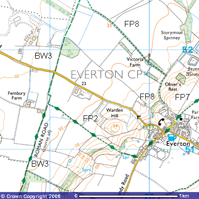
Just before the end of the runway, you can see the
signpost (TL 194528) for Bridleway 4, about 2,920m. in length, that takes you
on a ziz-zag route alongside field boundaries roughly ENE towards Woodbury
Sinks (TL 212526). This is a new footpath as an earlier map showed a path a
further 500 metres north running ESE from Woodbury Low Farm towards the foot of
the ridge. About 100 metres from the start of Bridleway 4 is the start of
Footpath 9, which, once it crosses the parish boundary, becomes Footpath
11. The main route keeps to the runway
for a further 100 metres until you see a large mound of concrete rubble,
remnants of dismantled roads and runways.
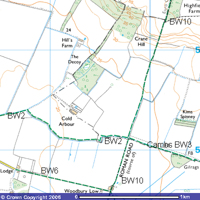
Although
a track runs alongside the eastern boundary of the new plantation of mixed
woodland, Bridleway 11 continues in a more northerly direction until it joins
the original route of the Roman Road by the hedge (TL 185533). It now becomes
Bridleway 10. After about 200 metres you will see a small copse through which
the track continues. The bridlway is marked on the map as following the eastern
side of the hedge, rejoining the Roman Road a few hundred metres further north.
Following the main track through the lder copse you might be able to sport some
black moorhens in the reeds surrounding a small pond. Reedmace and King Cups can be seen growing. Ox-eye
Daisies and the delicate yellow flowers of the Field Pansy can be spotted in
the undergrowth alongside the track. Once out of the copse
you will see Woodbury Low Farmhouse (TL 196536) and Woodbury Low Farm. A black.
corrugated iron garage, now a wood store, with a wind vane on the top, stands
at the junction of a concrete track that is Bridleway 6. Farm buildings, stores
and grain silos can be seen on both sides of the track running north and a
disused and boarded up Victorian farm building stands slightly to the east.
This area is said to have been an ancient site, like Valley Farm at the bottom
of the Greensand Ridge to the east. It may well have been a Roman and later a
medieval farmhouse.
540
 Footpath 6 (Everton) starts at the
Woodbury Low Farm crossroads and is a continuation of Bridleway 6 (Tempsford).
It is unusual as it is only about 250 metres in length and stops at a field
drain (TL 187534). Before the Air Ministry closed the footpaths and bridleways
running across the airfield, it probably connected with the settlement at Story
Moats to the southeast.
Footpath 6 (Everton) starts at the
Woodbury Low Farm crossroads and is a continuation of Bridleway 6 (Tempsford).
It is unusual as it is only about 250 metres in length and stops at a field
drain (TL 187534). Before the Air Ministry closed the footpaths and bridleways
running across the airfield, it probably connected with the settlement at Story
Moats to the southeast.
53 18 19
Bridleway
10 continues for a further 500 metres northwest past Woodbury Low Farm and
takes you to the county boundary of Bedfordshire and Cambridgeshire. A few
mature oak trees line the route and a number of new saplings have been planted
which will provide an attractive avenue in years to come.
Butterflies like orangetips and small tortoiseshells can be seen in the summer on the
teasels. This track forms part of the appropriately called Skylark Ride. Many
can be seen and heard in the skies overhead. Chattering Linnets can also be
spotted. Looking to
the east you can make out the white-washed rear walls of Tetworth Hall and the
red brick Old Woodbury Farm and Woodbury Home Farm in the trees on top of the
Greensand Ridge. A new wooden bridge has been constructed over the field drain,
where you meet Bridleway No. 2, This takes you towards Cold Arbour Farm (TL 192544), about 500 metres off to the west, and
Tempsford level crossing. Arbour means a resting place and it is often
associated with Roman roads. Perhaps the deserted rooms or ruins provided cold
shelter for travellers using this bridleway. There may well have been a Roman
villa as Samian ware (high quality, thin red
pottery). bone and coins dating from
between 161 AD to 378 AD have been found in the vicinity. There was a
significant Roman villa in nearby Tempsford in which a mosaic floor was found.
A coin dated 310 AD was found in the grounds of Woodbury Hall. The route
to the east is Cambridgeshire’s Bridleway No 3 which forms the northern route
for the Skylark Ride along the county boundary towards Tetworth Hall and
Gamlingay.
The
Roman Road continues to the north on the western side of the hedge. After a few
hundred metres the track begins to rise up a quite steep bank of about 1:10 to
the crest of Crane Hill. There are quite dramatic 270o views back
along the Greensand Ridge and across the airfield towards Tempsford and beyond.
The track then follows the western side of Highfield Spinney for about 700
metres to meet Drewells Lane (TL 203558), the road from St Neots to Gamlingay.
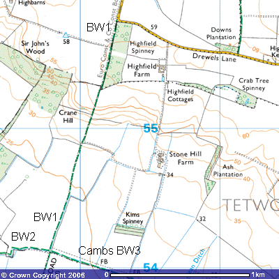 This
section of the footpath has been improved recently There is a sharp right-angle
bend in the road here and not much space for parking. Unfortunately, it has
been the focus of illegal fly-tipping and dumping of stolen cars in recent
years, so be careful about leaving your car here.
This
section of the footpath has been improved recently There is a sharp right-angle
bend in the road here and not much space for parking. Unfortunately, it has
been the focus of illegal fly-tipping and dumping of stolen cars in recent
years, so be careful about leaving your car here.
21 20