The Roman Road
BW27,
BW3, BW11, BW10 (Bedfordshire) + BW1 (Cambridgeshire) Distance: c. 6.75km.
Direction:
NNE – SSW
490 50 19 18
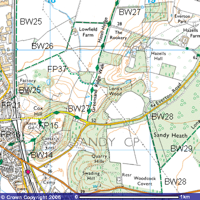 This bridleway and
footpath follows part of the Roman road that went from Baldock to the Roman’s
military station at Godmanchester (Durovigutum). It followed the route of an
earlier trackway used by the Catuvellauni, a local Iron Age tribe, that had
already settled and farmed what would then have been a well-wooded area. The
river and ridge top were important routeways as they had less trees and
clearings would have been made for housing and arable or grazing land. The
light soils and plentiful water supply protected from cold north winds by the
high wooded hill was a good site. Their
farmsteads were defended, unsuccessfully as it turned out, by two hillforts,
banked up earthworks on top of the Greensand Ridge.
This bridleway and
footpath follows part of the Roman road that went from Baldock to the Roman’s
military station at Godmanchester (Durovigutum). It followed the route of an
earlier trackway used by the Catuvellauni, a local Iron Age tribe, that had
already settled and farmed what would then have been a well-wooded area. The
river and ridge top were important routeways as they had less trees and
clearings would have been made for housing and arable or grazing land. The
light soils and plentiful water supply protected from cold north winds by the
high wooded hill was a good site. Their
farmsteads were defended, unsuccessfully as it turned out, by two hillforts,
banked up earthworks on top of the Greensand Ridge.
One
was subsequently called ‘Caesar’s Camp’, (TL 179491) about 67 metres above sea
level but what connection it had with an emperor is unknown. Another is on the
top of Galley Hill (TL 185478), about 61 metres above sea level near Sandy
Lodge. Other trackways from Cambridge, Bedford, Tempsford, Shefford, Potton and
Gamlingay crossed the River Ivel just below the western end of the Greensand
Ridge. Flood deposits of sand and gravel on the inside of the large meander
left islands that made for a much easier crossing point. There must have been
some trade with Roman occupied Gaul as ‘Belgic’ pottery from the early 1st
century, a burial urn and coins have been found in the hillforts and at the
site.
From
43 AD Emperor Claudius sent Roman troops under the command of Aulus Plautius to
take control of much of southern Britain. This area would have been taken over
by 47 AD. To control this important crossing point a small military garrison
was established. In time a small settlement grew up around it to supply the
troops. 19th century excavation and reported archaeological finds
have revealed a small mansio, the Roman equivalent of a military post office,
under what is now Sandy railway station (TL 178488). 20th century
work at the cemetery and in the allotments along Chesterfield uncovered the
site of a small settlement with an east-west gravel lane and streets running
south. The 3 – 4 metre rectangular timber-framed houses with wattle and daub
houses and thatched roofs were built on low stone footings facing the streets.
Some had clay grates or fireplaces. Many had adjoining workshops and small
gardens. There could well have been a wharf by the river at which trading
vessels docked. The Ivel and Ouse led to the Wash and the North Sea about 100
kilometers away.
The
variety of Roman archaeological artifacts found locally indicates that Sandy
was a small manufacturing and trading centre which developed over a few
centuries. They include Roman coins, glassware, a kiln, pottery from the 1st
to early 4th centuries, copper, silver, and iron smelting works,
bronze and pewter metalworking, religious icons, tweezers, jewellery, bone
pins, grape seeds and a burial ground containing a sword, ring, pots and human
remains. Other finds confirmed there to have been trade with other parts of
Europe. They include quern stones for grinding cereals from the Eifel River in
Germany, ivory from Italy, coins from Trier, Germany, high quality red Samian
ware pottery mass-produced in Gaul, mortaria (grinding bowls) from Oxfordshire
and decorated beakers from workshops in the Nene valley near Huntingdon. Some
of the Roman remains can be seen in Sandy Town Council offices.
The
Roman road continues north out of the town, up the Swaden, a sheltered valley
cut out by glacial meltwater, between Caesar’s Camp and Swaden Hill. It crosses
the saddle between them, along which runs Sand Lane, the old road from Everton
to Sandy. The woods of Cox Hill to the west, towards Sandy, have lots of
footpaths worth exploring. There is plenty of roadside parking available
beneath overhanging beech trees. Bollards placed on either side of the railway
bridge (TL 176494) have blocked vehicular access to and from Sandy. Parking for
the Roman Road is available by the junction of the old and new road from Sandy
to Everton, very close to the start of the bridleway at the field gate, about
50m above sea level, (TL 184493). It forms part of the Skylark Ride, East
Bedfordshire’s 36 km circular horse ride from Sutton, through Wrestlingworth,
across Biggleswade Common, up through Sandy Warren to join the Roman Road here.
So, if you don’t meet up with any horse riders, you will see plenty of evidence
of horses’ hooves in the mud along the way.
Once through the
field/kissing gate, Bridleway 27 goes down a gentle slope of about 1:15 through
a field of rough grass. You might see
sheep and cattle grazing on the tussocks but none of the stones that formed the
surface of the road. They were most likely “robbed out” following the Roman
troops leaving the area around 410 AD. Groups of Angles, Saxons, and Jutes
gradually settled the area, cutting down even more of the woodland and
developing it for agriculture. They would have used the stones in foundations
and building material for their houses and farms. By the 9th century
the route would have been used by pilgrims on route to and from the shrines to
St Alban and St Neot. To the east you can see Lord’s Wood, part of the Pym’s
estate. Following the Norman Conquest of 1066 the 1,632 hectares of Sandeia,
the Saxon name for sand island, were awarded to Eudo Fitzhubert, also known as Eudo the
Dapifer, of Colchester Castle. He was one of William the Conqueror’s High
Stewards. The wood may well have been named after him. This part of the estate
was given to Chicksands Priory, near Shefford, and
records show that in 1291 they owned a ‘Grange of Hayseles’. Twenty years
earlier, there was an incident reported in the Bedfordshire Coroners’ Rolls
that provides fascinating insight into life in the area at the time.
“After vespers on 9 Oct.
1270 Gilbert the Shepherd of Kinwick (a small hamlet near Hasells Hall), went from his house in the hamlet of
Kinwick in the parish of Sandy to his sheepfold a furlong (about 200 metres) outside the town on the east and did not
return that night. His wife Rose searched for him with her neighbours, and on
the next day through the neighbourhood in towns and fields and could not find
him. On 13 Oct. Gilbert’s son Hugh was watching sheep on Sandy Heath and there
found his father slain, being struck through the middle of the hattrel (?) apparently with an axe, raised the hue (call of murder) and ran
to the town. The neighbours came and the hue was followed. Hugh found pledges,
Ralph Wybet and Henry Blanfrunt, both of Kinwick.
Inquest before the same
coroner by Sutton, Potton, Everton and Sandy, who did not know who killed
Gilbert or where he was killed, but they knew that he was not killed where he
was found. Rose found pledges, Ralph Wybet and Peter the Shepherd of Kinwick.
The neighbours were attached: Peter the Shepherd by Hugh Rikeld and Martyn
Petyt; Martin Pretit by Hugh Aubre and Peter the Shepherd; William Aylline by
John Ayline and Robert the clerk; Richard Muriel by Hugh Ambre and William le
Marchant.
[At the eyre (a court of travelling justices) it was presented that Gilbert, who was
called Gilbert the Shepherd of the prior of Chicksands, was slain by unknown
felons’ who immediately fled. No Englishry were presented so murdrum was
imposed upon the hundred. The neighbours did not come and were not suspected;
their pledges were therefore amerced (fined). Martin Petit’s first pledge was called
Hugh Auvore. The four townships were amerced for not coming to the inquest.
(sic) J.I. 1/10, m.29d]”
(Bedfordshire
Coroners’ Rolls, Bedfordshire Historical Record Society vol. 41)
A
signpost in the field directs you about 400 metres across an uneven pasture
dotted with a lonesome Scots Pine, several willows and other trees. On the
lower slopes are intermittent ponds, only found after periods of prolonged rain
The
raised mounds in this lower field resemble house platforms and the dips ancient
trackways. Although there may have been a Norman settlement on this site, the
hamlet of Kinwick was probably where the circular field called Kinwick Field is
now, on the edge of the Hasells Park. You will see a field gate and kissing
gate Footpath 37 veers off to the northwest along the southern boundary of
Dame’s Orchard, one of a number of small plantations of woodland along the
track. (TL 184497). Maybe the descendants of her apple and pear trees still
survive within it? Almost all the woodland along the Roman Road was coppiced,
particularly with hazels which were cut down annually to just above ground
level and allowed to grow straight, tall branches that could be used for fence
palings, household equipment like pan and broom handles, tools and weapons
handles. The practice has largely stopped with the development of cheaper,
environmentally unfriendly plastic substitutes. This 400m. footpath meets up
with Bridleway 26 just south of Lowfield Farm. .
Just
beyond Dames Orchard starts what remains of Hasells Hedge, the medieval name
for this routeway. A modern telegraph line runs parallel to it to remind you
that you’re in the 21st century. The hedge’s age can be determined
by the number of different tree species found within it – one representing a
hundred years. After a further 300 metres you pass Hanging Croft (TL 186499).
It is unlikely that it was named after someone being found hanging there. The
name refers to a wood that grows on the slopes of a hill. Just beyond it you
can see The Rookery (TL 188501), woodlands along the foot of the hill. See if
you can spot the large black ravens gliding over the swaying canopy. Above it you
can catch a glimpse of Hazells Hall in its park at the top of the ridge (TL
189500). It was probably built on the same site as the Grange with commanding
views over the surrounding countryside.
When
Henry VIII closed down the monasteries and religious houses in 1534, he sold
the estate to Francis Pygott in 1542 who, in turn, sold it to John Burgoyne,
the landowner of the nearby Sutton estate. In 1635 it was sold to William
Brittain whose relative, Baron Brittain, rebuilt the house in 1698. It is
likely that this was an extension to an existing building. By this time, most
of the trees on the ridge top had been removed and the area was dominated by
heathland. Heylock Kingsley bought the estate in 1720 and enlarged Hasells Hall
in 1736. Thirteen years later William Pym, from Radwell, Hertfordshire, married
Kingsley’s daughter and heiress and started that family‘s ownership of the
Hasells estate.
It
was his son, Francis Pym (1756 – 1833), who developed the parkland by taking on
the services of Humphry Repton (1752 – 1815), the famous English landscape
gardener. Repton prepared Red Books for his clients which, in words, described the properties
with sketches and water-coloured drawings which showed the buildings and
grounds before and after his modifications. They were under the headings of Character, Situation, The House, Walls,
Drives (approaches), Water and
Kitchen Gardens. He promoted all year round interest in the gardens,
incorporating cast ironwork, a product of the Industrial Revolution, in his
decorations, as well as stone terraces, gravel walks, trellis screens,
pergolas, orangeries, piers, vases and flower beds. Grazing cattle and sheep
were encouraged to give life to the landscape. He commented that “I always
distinguish by the name of the Park that portion of wood and lawn which is seen
from the windows of a mansion. With respect to its size, there is one
invariable rule, it must appear to have no boundary.” To achieve this he removed
hedges and fences, screened nearby farms with plantations of coniferous trees
and felt that “cornfields were incongruous with the site and character of the
landscape to be viewed from an elegant mansion.” He produced two Red Books for Moggerhanger for Godfrey
Thornton was done in 1782. (Humphry Repton, Moggerhanger House
Preservation Trust)
The
Pym’s Red Book, dated 1791, is a prized family possession. In it Repton
described the approach to the Hasells entrance after climbing onto the long
ridge from Sandy as “...rough windswept country. After ascending the naked
hills from the village of Sandy the eye is disgusted by the vast expanse of
flat uninteresting rabbit warren”.
As the road from
Everton came close to the Hall, Repton proposed
enlarging the park towards the east by moving the road between Everton and
Sandy further away from the house. Drives were relayed to take advantage of the
undulating ground and the “beautiful
features of the park“. He suggested the erection of lodges by the new road.
One was to be a “mere cottage perhaps
rudely built of sandstone and thatched might be made a very picturesque Lodge
at the entrance“. This would draw
visitors' attention away from the dreary waste. He recommended some trees to be
removed to “give light and cheerfulness
to the scene“. Stone Lodge was built at the northern entrance to the park,
now a drive to Everton Park (TL 197503). Crimea Lodge, at the more southern
entrance to Hasells Hall (TL 189494), was not built until 1860. It was a
converted army hut brought back from Captain William Peel’s travels during the
Crimean War. This was from 1854 – 56 when British and French forces were trying
to push the Russian forces out of Sebastapol, part of what is now Rumania.
51 50
In 1837 to capitalize on the
ever-increasing demand for food from the London market, Mr Pym had Park Farm
constructed (TL 193501). That started the gradual process of reclaiming the
heathland for farming and pine plantations. The natural habitat was gradually
lost and wildlife suffered. In 1902 Frank Pym effectively doubled his
landownership by purchasing the Everton Estate from the Astells of Woodbury.
Frank Pym's game books show that large bags were obtained from the Hasells.
2,454 pheasants were shot over the winter of 1908-9. On one day the coverts in
the park were emptied of 1,000! The annual bag of was about 500 partridges, 175
hares and 2,500 rabbits.
Park
Wood was planted at the turn of the 20th century in the middle of
the estate which made a more attractive drive. By 1915 there were “difficulties
over the mortgages” which led to the sale of small parcels of land around
Sandy. Although the Hall was leased between 1858 and 1892 and again between
1941 and 1968 it has been the Pym’s principal residence from 1749 – 1948.
During
the depression in the 1930s many of the tenant farmers in this area could not
afford the rents and gave up farming. As a result most of the fields become
overgrown and brambles, hawthorn and hazels spread. Late
every afternoon tens of thousands of starlings used to fly over Everton and
descend the hill to roost in the bushes. The noise was terrific. They would all
fly off in great black flocks in the morning. Between 8 – 12 centimetres of
bird droppings accumulated underneath. William Flint was tenant of Waterloo
Farm. It is said that he paid his rent by shooting rabbits. During the War it
was taken over by Jonathon Hodson who used land girls to help with the work.
All this was ploughed up and drained during the construction of the airfield.
During
the Second World War, the Air Ministry, acting for the Special Operations
Executive, requisitioned the Hall. It was mainly used as an Officers’ Mess for
138 and 161 squadrons but secret agents often spent their last day at the
Hasells, receiving last minute instructions for their missions in occupied
Europe. before being driven down the hill to the airfield in a Daimlers or
Rolls Royce with their blinds pulled down. Fred Pym had the use of one or two
rooms and lived their until he died in 1941, His cousin and heir, Leslie Pym,
resided in Monmouthshire in Wales. In July 1945 Francis Pym inherited the
estate on the death of his father and became one of the trustees. He renamed it
Hazells Hall Farm, the z being preferred by over the s. He was rather tired on non-locals
pronouncing it Hassells. The Hall was allowed to be used first by the Women's
Land Army and then as the annexe of Bromham Hospital, near Bedford. When the
hospital’s lease expired in 1968 the Hall was very run down. It was boarded up
in 1969 and fell into disrepair. By 1978 permission was requested from the
Planning Authority for its demolition. Public awareness of national heritage
and conservation rather than wholesale demolition was growing and it got a lot
of press coverage. The alternative was to convert it into flats. Kit Martin, an
architect experienced in converting old properties, bought the Hall and
surrounding gardens in 1981 for £5,000.
It was divided into eight houses and four flats. The latter were in the
three storey west wing. Thus the owners of the houses were granted the freehold
and certain parts of the original gardens, whereas the owners of the flats were
granted the leasehold, together with the use of the shared grounds which formed
part of the original mansion gardens. These included the large walled gardens,
the orchard, the Long Walk, and the terrace. Thus ended 230 years of the Pym's
connection with Hazells Hall but Hazells Park Farm and the two entrance lodges
remain part of the Pym estate.
Everton
Park, a new family residence for the Pym family, (TL 193504) had been started
in the late-1960s. It was built in the grounds of Hasells Park close to the
Chestnut Avenue which marks the boundary with Everton parish. Francis and
Valerie Pym moved in in 1969. Sir Jeffrey Jellicoe, considered the greatest
20th century landscape gardener, and his wife Susan, an expert planstwoman,
designed the gardens in 1974. Mr Pym was sacked as Foreign Secretary during
Margaret Thatcher’s Conservative government, the only Foreign Secretary to be dismissed
in office.
Locals
call the Roman Road “The Creek”. You will understand why after heavy rain as
the the wet clay becomes waterlogged and deep puddles build up in the ruts left
after farm machinery has passed and in the hoof prints of horses. On the western
side of the track you will notice a remnant of World War Two, one of a number
of airraid shelters built on or near Tempsford Airfield. They are of identical
construction – a series of two prefabricted concrete slabs, bolted together at
the top in the shape of a Gothic arch from a Norman Cathedral. The western end
has a stable-door style window and the door is at the eastern end.
About
a 100 metres further on, a concrete farm track from the Hall comes down the
slope alongside The Rookery and crosses the Roman Road to become Bridleway 26
(TL 186503) This follows the track westwards to Lowfield Farm and on towards
the railway line and back towards Cox Wood and Sandy Station. The Greensand
Ridge Path continues north alongside Hasells Hedge for a further 700 metres
until the end of the field which marks the Sandy/Everton parish boundary (TL
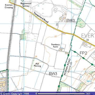
187507). The track then becomes Bridleway 3 in Everton parish and continues for
about a kilometre until you see some farm buildings on the west side of the
road. Since 2000 another local firm, Gilkes Fencing, has used these,
Immediately
to the north of these barns you can see the track going down to Waterloo Farm
(TL 188515). This was one of a number of new farms built on the Pym estate
following the success of the British campaigns against the French during the
Napoleonic Wars in the early-1800s. The Duke of Wellington defeated Emperor
Napoleon’s forces on June 18th 1815 at the battle of Waterloo in Belgium, a
famous event commemorated by Francis Pym, the then landowner, whose son was
killed in the battle. It has now been renamed Fernbury Farm. The owner, Eric
Baron, when he gave up farming in 2002, renovated one of the old barns and
developed it as a possible venue for weddings, dances, parties and even film
shows about Tempsford Airfield. The thread of a high Community Charge put paid
to this rural venture. All around this site were buildings like the YMCA hut,
grocery store, barber’s shop, ration store, dining room and education block.
Some of the larger buildings were engineering workshops where the vehicles were
adapted or repaired.
52
Other local farms built at the same time were
named after the trading ports used by the British merchant navy and the Royal Navy
during the Mediterranean campaigns against the Spanish and French e.g.
Gibraltar (1704), Portobello (1743). Port Mahon (1758) and Carthagena (1808).
The Astells, Thorntons and Pyms were all merchant families.
51
Aerial photographs of the fields immediately north
of Everton Park have revealed the site of a large settlement in one of the
fields on top of the ridge (TL 194506). Interestingly, the field is named on
Medieval maps as Settle Mead.
19 18
A
criss-cross pattern of trackways and what appear to be house platforms can be
seen covering a site of about 4.8 hectares (12 acres). It is thought that this
could have been a Roman agricultural settlement, just above the spring line.
The street pattern resembles that of Roman Sandy. As it is unlikely to be
excavated, it is difficult to say exactly when it was occupied.
Continuing
north along the track you meet Footpath 2 to the east (TL 189514). This 1150m.
path is the route of the Greensand Ridge Walk which takes you up the hill into
Everton. Continuing along the Roman Road there is another hawthorn coppice,
gaps in which might let you make out some of the concrete buildings associated
with Tempsford Airfield. Part of the institute and dining room still remain,
The rest of this site included officers’ and sergeants’ showers, the Commanding
Officer’s quarters, an Officers’ Mess, Sergeants Mess, staff quarters,
latrines, ration store, shower and decontamination block, education block and
fuel compound.
In
1988, Jonathon Pym, who had taken over the running of the northern part of the
Everton estate from his father, sold this plot of land to Jimmy Nunn, an
Everton entrepreneur, who developed the site for Bedfordshire Seamless Gutters.
It was later renamed BSG Property Services. Its address is Lysander Place,
named after the famous Lysander airplane of World War Two. It was a small
aeroplane, designed to land and take-off from runways as short as a football
field, so it was ideal for the job of dropping off and picking up secret agents
and VIPs. It also had the great advantage of being so similar to a German
aircraft operating at that time in occupied France, that it was frequently
mistaken for the Germans’ own. It had a top speed of 336 km (210 miles) an hour
and a range of 1,120 km (700 miles). It was nicknamed by some “The Flying
Carrot”, thanks to the shape of its fuselage.
The
importance of successful missions meant that pilots were asked for their
suggestions for improving the flying potential of the planes. Given the nature
of the secret work they were involved in, their ideas could not as easily be
incorporated into the manufacturers’ design. This necessitated specially
trained fitters and mechanics on the base. Several hundred skilled men were
drafted in to maintain 138 and 161 squadrons. One feature that pilots
incorporated into the Lysander was a slight angle on the front of the wings
which increased the range of vision from the cockpit. To speed up the
turnaround, a stepladder was permanently attached to the side near the door. It
is claimed that it was the only ‘plane with such an attachment. The top of the
rungs were painted yellow to make them more visible during night-time
operations. The armour plating, bomb racks, long-range radios and machine guns
were removed to reduce their weight and increase their speed and range. With a
squeeze it could carry up to three passengers. This was not enough space, so
the floor was extended to allow up to four passengers and their luggage in the
rear cockpit.
To
increase its range the fitters attached 150-gallon (568-litre) Handley Page
Harrow fuel tanks above the wheels on the fixed undercarriage. These were
called ‘spats’. Another was added underneath the fuselage. This meant that
round trips of up to 1,440 km (900 miles) were possible.
Originally
the ‘planes were painted matt black to reduce their night-time visibility. It
was found that this gave them a sharper silhouette against low cloud. The
solution was to leave the undersides black but to camouflage the wings and
upper parts of the fuselage with pale grey and dark green. Its uses during the
Second World War were varied, i.e. air sea rescue, target tow, tank busting,
aerial reconnaissance and glider tow. It really gained its fame however from
the secret operations it was used for from Tempsford Airfield.
About
300 metres from Fernbury Farm the bridleway crosses the Tempsford Road (TL
191517) and continues north across the disused Tempsford Airfield. There is a lay-by on the north side of the
road for parking but it needs to be noted that illegal fly-tipping and thefts
from cars have been reported here. Following the concrete track a further 300
metres alongside the hedge would have taken you past the civilian canteen and,
by the oak tree, (TL 191519), two maintenance blocks and two stores. Past the
tree one can make out a trackway to the east leading into an overgrown field of
bushes and hawthorns, marked on the map as ‘The Sanctuary’. This was once a
taxiway leading to two large (and now dismantled) aircraft hangars. In the field to the west, about 300 metres
before you reach the main NW—SE runway, were solid fuel and bulk aviation fuel
compounds. The buildings that you can see immediately to the west are private
property and some of the few remaining on the airfield (TL 188521). They used
to be barracks, a clothing store, base accounts and 138 squadron offices, a gas
clothing store, latrines for technical staff, a gas respirator store and a
lubricants and inflammable store. Today
they are the stores and farm office of Tempsford Airfield Farm. The two
semi-detached houses were built after the war to house the farm manager and
other workers on the estate.
When
the runway was built, it did not follow the line of the Roman Road. It runs less
than 100 metres away to the west. Just after Port Mahon Belt (TL 183523), a
mixed plantation running WNW – ESE, you can see a wide concrete runway
alongside it. About 200 metres further on you can’t avoid the black-painted
weather-board barn (TL 192626) which in 2004 was given Grade II Listed Building
status. This is the only remaining part of Gibraltar Farm, the 19th century
building that became the nerve centre of the secret operations on the airfield.
Although most of the airfield lies in Everton parish, Gibraltar Farm was just
over the parish boundary in Tempsford. Access for the “top brass” in the RAF
was often via Tempsford Station, hence it becoming most widely known as
Tempsford Airfield. Guarded day and night, only a handful of people knew the real
purpose of the farmhouse. The roof tiles of the original house and outbuildings
were removed to make the site look derelict. For the same reason, much of the
weather-boarding was removed. Inside, the stairs, ceiling and first floor were
removed to create a very large room. The inside walls were built up and
reinforced. The pond was left and its ducks still swam on it. In Jerrald Tickell’s Moon Squadron he
commented that
“‘Gibraltar
Farm’ was a real farm. No doubt about that. But instead of land-girls, those
popsies in green jerseys, there were more guards hanging around the muckyards
and there was a duck-pond. A duck-pond with live ducks quacking on it. Another
thing that struck me as being very curious. On the nights when I heard aircraft
going out, I couldn’t use the telephone. No calls allowed, and if I went out to
a public call box, that had a socking great chain and padlock on it.
It
had one wall completely covered with maps of France, Belgium, Holland and so on
and in each map small pins were placed, each pin representing an exact place
for a drop zone and resistance reception group.
The
French map was literally covered in little flags, some areas thicker than
others which was a graphic display of the growth and development of French
resistance.
In
this room a WAAF [Women’s Auxiliary Air Force] would hand the navigator the
latitude and longitude of the target area. The navigator would study the map
regarding the exact drop zone and make careful note of the areas marked in
“red” which were flak areas with designation of type of guns, be they 20 mm or
30 mm, which had to be avoided.
For
the rest of the day the crew would split up. The pilot, flight engineer,
wireless operator and rear gunner would go to the aircraft for a flight test
and would test the guns and wireless equipment, including the S-phone and
‘Rebecca’ location radar.
Meanwhile,
the navigator and bomb-aimer would take their maps to the large table in the
navigation office and plot the night’s targets and the best route, calculating
the course to be flown to miss flak areas and large towns and making
calculations of predicted wind speed and direction. Later in the day it was
back to HQ to the intelligence office to meet the Army Officer (SOE) who
produced very large-scale ordnance survey maps of each drop zone to give a good
picture of the terrain. After this meeting they would collect occupation money
(the currency used in France and issued by the Germans) a packet of it for each
crew member together with a silk map of France for them to use if they were
unfortunate to be shot down, in which event the map would help them to at least
walk in the right direction. The money and maps would be returned to the office
on de-briefing on their return.
They
were also given colour-coded cartridges for the Very pistol which was the
German colour of the day. (This information probably came from ‘Ultra’, a
secret de-coding device).
It
is probably common knowledge these days that aircrew were issued with collar
studs which, when the paint was scraped off, revealed a small compass and
trouser buttons which, when removed and supported at the centre of a pin,
pointed north. They were also issued with a fountain pen clip, which, when
removed and supported on the nib, again pointed north.
There
were cigarettes issued to the crew that had no brand name or name of
manufacturer. These were usually lit for the crew by the navigator in his
screened-off compartment. All highly irregular.
The
last duty before taking a short nap was to book an operational meal. This consisted
of eggs and bacon and it was given as a type of symbol, a privilege and a
reward to those that had chosen to fly with bomber command. With things as they
were in Britain in 1943, it was a banquet.
Before
you go inside the barn, note the small trees planted outside. At their base you
can see small plaques commemorating some of the pilots and crew who flew from
Tempsford. Inside is a very special
memorial to “…the brave deeds of the
men and women of every nationality, who flew from this wartime airfield to the
forces of the Resistance in France, Norway, Holland and other countries during
the years 1942 to 1945.” Notice how the inside of the barn has been
reinforced with brickwork. The concrete shelving was where the agent’s
parachutes and other vital supplies were stored. They were brought here to pick
up this equipment immediately before take off.
The
Women’s Auxiliary Air Force (WAAF) were stationed in a camp in Everton village
at the top of the hill and one of their jobs was to pick up the ‘Joes’, the
term then used for secret agents, from their ‘safe houses’ and take them for
their moonlit flight or to be at the barn in the early mornings to pick up
returning crews and agents. Bob Body described their role in his book Taking
the Wings of the Morning.
For the agents; their
journey to the waiting aircraft started when a WAAF driver brought a car to the
barn to collect them; she would have been under no illusions regarding the
importance of the security that was required. One of these drivers recalled the
instructions she had been given regarding the conveyance of the agents to the
waiting aircraft. She said that the car was driven up to the barn where she had
to wait, eyes facing front whilst the passengers were ushered into the rear of
the vehicle. Under no circumstances was she to talk to the passengers or turn
around to look at them and the use of the rear mirror was forbidden. As she
obeyed these instructions to the letter, to this day she does not know who she
ferried out to the waiting aircraft, not even if they were male or female. Once
at the aircraft the car had to be reversed up to the door of the aircraft,
using only wing mirrors, no use of the rear view mirror or turning around to
see out of the back window. A tricky manoeuvre made more difficult by the
palpable tension within the vehicle. The rear doors of the car were opened by a
waiting crew member and the agents exited the vehicle leaving the driver to
return to her station.
Opposite
the memorial barn is the start of Footpath number 8 (TL 184526). This path,
about 1,500m. in length, takes you southeast alongside a field called The
Butts, past Happy’s Plantation and up the hill towards St Mary’s parish church
in Everton. It used to be the ancient route between Everton and Tempsford. Part
of it was closed when the Airfield was built but you can see its continuation
on the map as Footpath 4 at the northeast end of Little Biggin Wood (TL
182534).
Some
traditions still to be found on the local estates are the hunt and the shoot. About
twice a year, the baying hounds of the Cambridgeshire Hunt race over these
fields, often closely followed by a pack of horn-blowing, red-jacketed riders
on horseback. It is not easy to tell whether it is a drag hunt or whether
they’ve sniffed a fox. Certainly, there are foxes in this area, so beware if
one is running towards you. This hunt started in the 18th century
and in 2001 amalgamated with the Enfield Chace of Hertfordshire. There are
often shoots, which can be a little nerve-wracking if you suddenly hear shots
and see a flurry of feathers fall from the sky. You may well be warned by
seeing or hearing human activity in the fields around the copses. They tend to
wear camouflaged clothing, carry guns and drive off-road vehicles.
The
route now becomes Bridleway 11 and follows the runway just east of the Everton
– Tempsford parish boundary. Judy Knight,, the Bedfordshire naturalist,
commented on this particular walk that
at
first this does not look very promising for the naturalist walker, but there is
on the right a long carpet of stonecrop, a low-growing succulent plant that is
at home on the dry path beside the ditch. Coltsfoot abounds, its yellow flower
heads appearing in March before the round leaves, shaped - of course - like a
horse’s hoof. Many Cowslips grow along the bank of the ditch, their clusters of
delicate yellow flowers streaked inside with orange – a real sign of
spring. Houndstongue, a purple-flowered
relative of Comfrey, grows here - said to smell of mice! The breathless song of
the Skylark may be heard overhead; if you are fortunate you may see one
hovering in his song-flight and then plummeting down to a possible nest site on
the ground.
52 51 19 20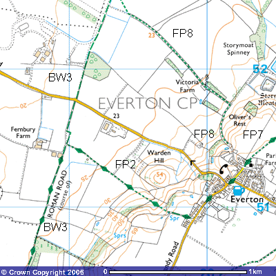
Just before the end of the runway, you can see the
signpost (TL 194528) for Bridleway 4, about 2,920m. in length, that takes you
on a ziz-zag route alongside field boundaries roughly ENE towards Woodbury
Sinks (TL 212526). This is a new footpath as an earlier map showed a path a
further 500 metres north running ESE from Woodbury Low Farm towards the foot of
the ridge. About 100 metres from the start of Bridleway 4 the Ordnance Survey
map shows the start of Footpath 9, which, once it crosses the parish boundary,
becomes Footpath 11. Alterations to the paths and bridleways in this area mean
that Footpath 9 and Footpath 11 will now start where the hedge meets the Roman
Road (TL 195532) and run along its southern side west to Tempsford. The main
route keeps to the runway for a further 100 metres until you see a large mound
of concrete rubble, remnants of dismantled roads and runways.
The
revised route takes you to the west alongside a new plantation of mixed
woodland, Bridleway 11 continues in a more northerly direction until it joins
the original route of the Roman Road by the hedge (TL 185533). It now becomes
Bridleway 10. After about 200 metres you will see a small copse through which
the track continues. The bridleway is marked on the map as following the
eastern side of the hedge, rejoining the Roman Road a few hundred metres
further north. Following the main track through the lder copse you might be
able to sport some black moorhens in the reeds surrounding a small pond. Reedmace and King Cups can be seen growing. Ox-eye
Daisies and the delicate yellow flowers of the Field Pansy can be spotted in
the undergrowth alongside the track. Once out of the copse
you will see Woodbury Low Farmhouse (TL 196536) and Woodbury Low Farm. A black.
corrugated iron garage, now a wood store, with a wind vane on the top, stands
at the junction of a concrete track that is Bridleway 6. Farm buildings, stores
and grain silos can be seen on both sides of the track running north and a
disused and boarded up Victorian farm building stands slightly to the east.
This area is said to have been an ancient site, like Valley Farm at the bottom
of the Greensand Ridge to the east. It may well have been a Roman and later a
medieval farmhouse.
540
 Footpath
6 (Everton) starts at the Woodbury Low Farm crossroads and is a continuation of
Bridleway 6 (Tempsford). It is unusual as it is only about 250 metres in length
and stops at a field drain (TL 187534). Before the Air Ministry closed the
footpaths and bridleways running across the airfield, it probably connected with
the settlement at Story Moats to the southeast.
Footpath
6 (Everton) starts at the Woodbury Low Farm crossroads and is a continuation of
Bridleway 6 (Tempsford). It is unusual as it is only about 250 metres in length
and stops at a field drain (TL 187534). Before the Air Ministry closed the
footpaths and bridleways running across the airfield, it probably connected with
the settlement at Story Moats to the southeast.
53 18 19
Bridleway
10 continues for a further 500 metres northwest past Woodbury Low Farm and
takes you to the county boundary of Bedfordshire and Cambridgeshire. A few mature
oak trees line the route and a number of new saplings have been planted which
will provide an attractive avenue in years to come.
Butterflies like orangetips and small tortoiseshells can be seen in the summer on the
teasels. This track forms part of the appropriately called Skylark Ride. Many
can be seen and heard in the skies overhead. Chattering Linnets can also be
spotted. Looking to
the east you can make out the white-washed rear walls of Tetworth Hall and the
red brick Old Woodbury Farm and Woodbury Home Farm in the trees on top of the
Greensand Ridge. A new wooden bridge has been constructed over the field drain,
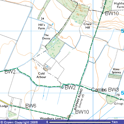
where you meet Bridleway No. 2, This takes you towards Cold Arbour Farm (TL 192544), about 500 metres off to the west, and
Tempsford level crossing. Arbour means a resting place and it is often
associated with Roman roads. Perhaps the deserted rooms or ruins provided cold
shelter for travellers using this bridleway. There may well have been a Roman
villa as Samian ware (high quality, thin red
pottery). bone and coins dating from
between 161 AD to 378 AD have been found in the vicinity. There was a
significant Roman villa in nearby Tempsford in which a mosaic floor was found.
A coin dated 310 AD was found in the grounds of Woodbury Hall. The route
to the east is Cambridgeshire’s Bridleway No 3 which forms the northern route
for the Skylark Ride along the county boundary towards Tetworth Hall and
Gamlingay.
The
Roman Road continues to the north on the western side of the hedge. After a few
hundred metres the track begins to rise up a quite steep bank of about 1:10 to
the crest of Crane Hill. There are quite dramatic 270o views back
along the Greensand Ridge and across the airfield towards Tempsford and beyond.
The track then follows the western side of Highfield Spinney for about 700
metres to meet Drewells Lane (TL 203558), the road from St Neots to Gamlingay.
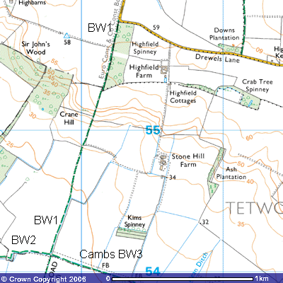 This section of the
footpath has been improved recently There is a sharp right-angle bend in the
road here and not much space for parking. Unfortunately, it has been the focus
of illegal fly-tipping and dumping of stolen cars in recent years, so be
careful about leaving your car here.
This section of the
footpath has been improved recently There is a sharp right-angle bend in the
road here and not much space for parking. Unfortunately, it has been the focus
of illegal fly-tipping and dumping of stolen cars in recent years, so be
careful about leaving your car here.
21 20