Bridleway
26
Distance:
1,250m. Direction: SW - NE,
W - E,
49 50 222 21
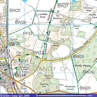 About
200 metres north of the former Morgan/Matroc factory to the east of the
embankment of the Great Northern Railway line, this Bridleway veers off from Bridleway 25 to the
northeast (TL 177497). It takes you roughly northeast,
alongside a mature, largely hawthorn hedge on the northwest boundary of a field
of the yellow flowering rape (from which we get rapeseed oil) towards Lowfield
Farm. In the distance you can see the
red-bricked Hazells Hall amongst the trees on the Greensand Ridge. Whilst the
OS map identifies shows Hasell Hedge running along the east side of the Roman
Road, when Francis (later Lord) Pym, inherited the estate in 1945, he changed
the name of the Hall to Hazells. He was rather tired on non-locals pronouncing
it Hassells.
About
200 metres north of the former Morgan/Matroc factory to the east of the
embankment of the Great Northern Railway line, this Bridleway veers off from Bridleway 25 to the
northeast (TL 177497). It takes you roughly northeast,
alongside a mature, largely hawthorn hedge on the northwest boundary of a field
of the yellow flowering rape (from which we get rapeseed oil) towards Lowfield
Farm. In the distance you can see the
red-bricked Hazells Hall amongst the trees on the Greensand Ridge. Whilst the
OS map identifies shows Hasell Hedge running along the east side of the Roman
Road, when Francis (later Lord) Pym, inherited the estate in 1945, he changed
the name of the Hall to Hazells. He was rather tired on non-locals pronouncing
it Hassells.
Above
the treeline you can see the 200 metre-high Sandy TV Transmitter and running
parallel to the footpath are several pylons carrying the electricity
transmission line from Little Barford Power Station. After about 600 metres, you
meet Footpath 37 running along the southwest side of a hedge back towards the
Roman Road (TL 181499).
On
the northwestern side of the track, through a gap in the hedge, you can see one
of many airraid shelters built on or near Tempsford Airfield during World War
Two. They are of identical construction – a series of two prefabricted concrete
slabs, bolted together at the top in the shape of a Gothic arch from a Norman
Cathedral. The western end has a stable-door style window and the door is at
the eastern end. Some have an escape route through a man-sized square tower at
one end with a rusting iron ladder dangling precariously from the opening.
Access is very overgrown with nettles, thistles and chickweed and inside is an
untidy mess including an old settee. About 250 metres later, the track goes
under the electricity transmission line from Little Barford Power Station, near
St Neots. At the bend in the track, another air raid shelter can be seen in the
field to the east. If you look further across you should be able to spot
another two.
There
are several paddocks in the field just to the south of Lowfield Farm in which
you might see horses and foals. Lowfield Farm itself is one of a number of
late-19th century Victorian Farms built on the Pym estate. The
black, weatherboard outbuildings and barns are typical Bedfordshire
agricultural buildings. You may spot a peacock strutting around in the farmyard
in front of the stables. Opposite the farm are two large, more recent grain
stores and a concrete storage area. Although the farm track continues NNE into
the fields the concrete track veers to the east at the northern edge of the
small copse (TL 183503). It continues
for about 400 metres to meet Bridleway 27 on the Roman Road TL 186503).. The
concrete track continues up the slope of the Greensand Ridge alongside The
Rookery towards Hasells Hall Farm but this is private land with no right of
way. In late-spring and summer you
should hear the bleating lambs and the calls of their mothers. Taking Bridleway
27 (The Roman Road) south you reach
the junction of Everton Road, The Swaden and Sand Lane. Following Hasells hedge
to the north takes you along the Greensand Ridge Walk towards Fernbury (formerly
Waterloo) Farm,Tempsford Airfield and Everton Village.,