Bridleway 7
Distance c. 500m. Direction N - S
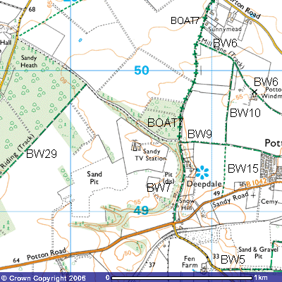
21 20
Bridleway
7 runs north to south through Deepdale, along the parish boundary between Sandy
and Potton. It used to be the route between Sandy Road and Everton Road. There
is a car park outside the entrance to the Sandy TV transmitter (TL205495). It
starts (or finishes) at the crossroads in the woods that line both sides of the
track (TL 207505). To the north is BOAT7, a bridleway
open to all traffic. However, it needs to be said that the route is somewhat
overgrown in places and fallen tree trunks make it impassable with even
four-wheel drive vehicles. Horse-riders and walkers have created paths higher
up on the western side of the track.
21 20
The
concrete road to the west is a permitted
footpath through the Everton estate that takes you onto Sandy Road,
Everton. To the east is a farm track that continues for about 800 metres
towards Potton. Bridleway 7 continues south along the road past a few
smallholdings built into the west-facing side of the valley. You may notice
some ‘Danger — Quarry workings’ on the fence to the west. These were the 19th
century coprolite workings which were subsequently exploited for the sand by
Redland Gravel and then Lafarge Aggregates. It was in this pit that the remains
of an iguanodon were found in 1866. Its claw, teeth and bones can be seen
amongst the Greensand fossil collection in the cabinets of the Sedgwick Museum,
Downing Road, Cambridge. If you ask the curator nicely they may well unlock the
lower drawers and show you other Potton fossils.
Fortune Farm was converted
into Deepdale Water Gardens in the 1990s. It specialises in cold water and
tropical fish but also sell accessories and supplies, ponds, statuary, birds,
rabbits etc. Landscaped gardens with seating around a large fishpond provide a
welcome respite for walkers and visitors to the shop. Cold drinks, ice-creams
and sweets are available.
Continuing south the
bridleway emerges from woodland onto an open field to the west where Tim
Sharrock, the Bedfordshire ornithologist, commented that
Skylarks
may be heard singing overhead and the twitter of pairs or small parties
of Linnets. This is also a site for the much less widespread Corn Bunting, with
his jangling song likened to the sound of a bunch of keys. Brown and streaky,
this is a bird slightly larger than a sparrow, but much chunkier, flying
awkwardly, often with its legs dangling, to a perch in an isolated tree, a bush
or tall herb.
The vegetation here is mostly ‘weed free’, but the odd
unsprayed patch may be a treasure trove of interesting and beautiful plants
typical of sandy field margins – Lady’s Smock, Scented Mayweed, Pineapple
Mayweed, Field Pansy, White Campion, Prickly Poppy and the purple-flowered
Common Fumitory. Around the farm buildings, typical birds are Barn Swallows and
Pied Wagtails, finding nest sites as well as food close to Man.
Snow Hill, the next house
to the south, marked on the OS map as Grove Lodge, also has beautifully
landscaped gardens. They are normally open to the public once a year as part of
the Open Gardens Scheme. Posters appear several weeks beforehand with
advertisements in the Biggleswade Chronicle and Bedfordshire on Sunday.
On the western side of the
road there was a small tramway running along the northern edge of the field in
the second half of the 19th century. It led
down a small valley along the western side of the wood from the Sandy
Heath coprolite works. A horse and cart pulled wooden trucks laden with fossils
to one of three washmills for the coprolite works. One of these washmills stood
in the corner of the field (TL 206490) where the fossils were washed and sorted
before being trucked to the railway station at Potton or Sandy. There used to
be a public house called The Locomotive at this junction with Potton Road (TL
207489) but it was converted into a house in 2002. Local people working at the
coprolite works used to call in for breakfast at 06.00am before starting work.
The house on the opposite side of the road also used to be a pub, opened for
the fossil diggers in the late-1860s and appropriately called the ‘Pick and
Shovel’.
The concrete road was constructed during
the Second World War to provide better access for ammunition trucks. Huge
quantities were stored in these and other woods in the area. In 1944 Peter Wisson witnessed an accident in the
playground of Everton School during his afternoon break.
The weather was bright with
high broken cloud. We first noticed the aeroplane high in the sky to the east
at an elevation of 80 degrees. It was in a vertical spinning dive. It was not
on fire and did not appear to be damaged, but I do not recall hearing any
engine noise. It seemed to be falling for ages but suddenly it hit the ground
and a large cloud of black smoke rose up from the direction of Potton. It was a
twin-engine aeroplane with a single tail fin. We saw no parachutes emerge from
the aeroplane. A day or two later I was taken to see a crashed aeroplane along
the Potton to Sandy Road. The aeroplane was badly damaged but I do remember the
tail was fairly intact and it had a single fin. The crash location is on the
right of the Potton-Sandy Road, about 50 yards from the road, to the west of
the recreation ground midway between two detached houses, map reference 213493.
I assumed this was the aeroplane which I saw crash.
Jim Breeze provided more
details about how a Stirling, LK 236 ‘MA-Y’, from 161 Squadron, crashed on 14th
February. As the event was shrouded with secrecy it was only in recent years
that research in the Imperial War Museum’s records has allowed the truth to
come out. F/O Eric Timperley and his six crew were returning from bombing
practice on the Wash in murky conditions when at 14.15 hrs it was ‘buzzed’ by a
P51 Mustang of the 383 Fighter Squadron USAAF. A witness saw it go up through a
gap in the clouds and make “an unauthorised pass”. It flew too close and hit
the Stirling’s tail. Both aircraft went out of control. Part of the American
plane came down in houses immediately behind the old Fire Station in Cambridge
Road, Sandy and part hit the allotments near the railway bridge below Cox Hill,
east of the town. Fred Punter who witnessed the event as a young boy in Sandy
stated that the American pilot, Lt. T.W. Kiley, bailed out but, being so low,
his chute failed to open. He landed feet first and sunk in the sand up to his
waist. His plane landed on top of him and burst into flames. The Stirling dived
into a field near the present day site of Sandy television mast. The tail
landed close to the crossroads in Deepdale, opposite the Locomotive public
house.. F/O Timperley and six of his crew were killed. They included two
Australians, F/S Bill Saunders and F/O G.C. Wiggins from the RAAF.
A local man recalled how, as a
youth, he rushed to the crash site on his bike, saw ammunition going off in the
fire and containers rolling down the slope. He ran over to the crash to help
and was afterwards sworn to secrecy. The landlord of the Locomotive public
house is reported to have found an arm and buried it beneath a tree by the side
of Potton Road. Parts of the plane were unearthed in gardens behind Peels Place
in Sandy.