Bridleway 8 (Sandy)
Direction W-E, Distance
about 500m.
BW8
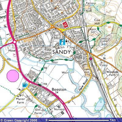 Bridleway
8 is part of the Bedfordshire’s premier footpath, the 40 mile (64 km.)
Greensand Ridge Walk between Leighton Buzzard and Gamlingay. It starts where
the walk crosses the footbridge over the weir across the River Ivel south of
Sandy (TL 170487). The large pool was the millpond belonging to a Norman
watermill and its replacement constructed in 1857 when the Ivel Navigation
allowed river traffic down to Biggleswade. When it fell into disuse it was
recently demolished and replaced with flats. Unlike most of the route of the
Greensand Walk it is a tarmac path. There are iron railings along part of the
route, the rest were removed during the Second World War as a contribution for
the war effort.
Bridleway
8 is part of the Bedfordshire’s premier footpath, the 40 mile (64 km.)
Greensand Ridge Walk between Leighton Buzzard and Gamlingay. It starts where
the walk crosses the footbridge over the weir across the River Ivel south of
Sandy (TL 170487). The large pool was the millpond belonging to a Norman
watermill and its replacement constructed in 1857 when the Ivel Navigation
allowed river traffic down to Biggleswade. When it fell into disuse it was
recently demolished and replaced with flats. Unlike most of the route of the
Greensand Walk it is a tarmac path. There are iron railings along part of the
route, the rest were removed during the Second World War as a contribution for
the war effort.
You
can probably tell that you are walking follows the northern side of an island.
Sandy was known in Saxon times as Sandei and in medieval times as Sandye,
meaning sand island. This island is known as ‘Sandcast’ and is mostly water
meadows, occasionally grazed by cattle and sheep. There is a wooden gateway on the
north side of the fence which provides access to an alternative route along the
top of the river bank. Although it can get overgrown during the early summer
it’s worth venturing onto as you can get glimpses of Sandye Place, an ancient
park belonging since Norman times to the Beauchamp family. The large 18th
century mansion with its tiered terraces is now a Junior School. The grounds
used to have an avenue of lime trees going to St Swithun’s Church. During
Edwardian times the garden was laid out in a willow pattern. A Chinese bridge
crossed the river to the island and a boathouse used to stand on its northern
banks. An ironstone dovecote can be spotted in the grounds. From 1869 the
grounds were the site of the Sandy Show, the largest one-day event in the Midlands.
It ran for over eight years and put Sandy on the social and national map. This
riverbank alternative route rejoins the bridleway about 100 metres upstream.
The
tarmac path follows the south bank of the river to another footbridge. A plaque
on the outside indicates it was built in 1878 by F. Taylor. You might be lucky
and see some white swans on the river but, depending on the time of year,
there’ll most likely be ducks. The
bridleway ends where it meets Ivel Road (TL175498)
Although
it is not a designated public footpath or bridleway there are signposts
indicating the continuation of the Greensand Walk. Turning north you follow
Ivel Road with its largely 19th century cottages for about 200 metres
past the Fire Station until you meet the High Street between the Market Square
and Sandy Station. Carefully cross the road and go up St Swithun’s Way directly
opposite and turn first right into Stone Croft (TL 177491). This is the start
of Footpath 16.
At
the end of the hedge turn left and you should see a signpost indicating a path
between the back gardens of the houses that takes you to the footbridge over
the main railway line. Footpath 16 follows a trackway to the north which, after
about 300m, takes you to Cambridge Road and the road bridge over the railway.
The Greensand Ridge Walk goes over the footbridge onto a track running above
the top of the railway cutting. In front you can see across the field to the
woods surrounding Caesar’s Camp. This is Footpath 15
which takes you up to the top of Clon Hill. The track to the north, takes you
through the trees and up a steep bank of about 150 metres to a viewpoint and a
bench. The views over Sandy and the Ivel valley are worth seeing.