Bridleway No. 2
and Footpath No. 2
Distance:
c.1150m. Direction: WNW
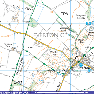
Bridleway
No. 2 and Footpath No. 2 starts opposite a terrace of four red-bricked cottages
at the south end of Everton. They were constructed in 1915 for employees of the
Pym estate (TL 198508). Local gossip says that they were provided for returning
soldiers from the First World War, provided they helped in the construction.
Most conscripts would have been estate labourers so learning some construction
skills would have been thought useful. A Greensand Ridge signpost and a carved
tree stump marks the route. The bridleway follows another ancient trackway,
between Sandfield Close and Brookland Close. It is known today as ‘Warden Gap,’
along which farmers took their cattle to and from grazing on the fields on and
below the ridge.
19 20
The path is lined by ancient hedgerows, determined
by the number of species found in it. It is claimed that one species represents
one century. See how many you can spot as you walk along it. It passes the
entrance to a field of rough pasture where you might see a horse grazing or
sheltering in its stable.
Once
you go through the kissing gate (TL 197509) it becomes Footpath No. 2. You can
get some stunning views along the Greensand Ridge. These are quite exceptional
for Bedfordshire, especially when there is a storm approaching on the
prevailing south-westerly winds or when the sun is setting on a fine evening.
There are plans to erect a greensand monolith by the spring once you pass
through the gate and place a seat where you can enjoy the view. Similar
monoliths can be found at other points along the Greensand Ridge Walk. Until
1975 there used to be a line of several hundred-year-old elm trees that
followed the ridge top. The Dutch elm beetle affected about 80% of the
country’s elms and the remedy was wholesale felling. Rotten tree boles up to
three metres across can be found in some places along the ridge top.
This
gently sloping field, known as Long Hill with a gradient of 1:10, is the main
sledging run in the village. Many of the local youngsters, and the more active
adults, get out their sledges, toboggans and snowboards after only a few
centimetres of snow.
Once
you start to descend the hill you are going back millions of years in
geological time. The top of the hill at 66 metres is the remains of a much
higher ridge that was heavily eroded during recent ice ages. How many metres of
sand the advances and retreats of the ice sheets scraped off is unknown. It is
very likely that much of the softer Upper Greensand was washed away when the
last ice sheet melted between 13,000 and 9,000 years ago. It is the Lower
Cambridge Greensand that makes up Bedfordshire’s Greensand Ridge. It started to
be deposited about 94.5 million years ago on top of impermeable Oxford Clay.
This deep bed of clay started to be laid down in shallow seas about 500 million
years ago, when this part of NW Europe was much further south, about 28o S.
of the Equator. Now its surface is the heavy soil that clings to your boots or
wellies in wet weather. When you’re scraping it off just remember it’s really
ancient, many millions of years old!
There
is a theory that asteroid activity about 94.5 million years ago caused a mass
extinction, burning up the oxygen, causing fiercely hot winds and a several
hundred metre high tidal wave that flooded the coastal areas. The impact would
broken through the few kilometre thick Earth’s crust, caused extensive
earthquake and volcanic activity, and released vast quantities of poisonous
Carbon Dioxide and Sulphur Dioxide into the atmosphere. It is claimed to have
wiped out about 70% of all life. The section of the Earth’s plate upon which
this part of Northwest Europe lies, would have been shifted into the desert
latitudes from which the Greensand originated.
The
reason for it being called greensand is that it contains minerals of
glauconite, blue-green crystals with a complicated chemical formula (K0.08
R1.33 R0.67 [Al0.13 S3.87 O10]
OH2) that turn green when they are first exposed to the oxygen in
the air. However, after a while they change to the dark brown colour that you
will notice further south on exposures in the Sand Hills above Sandy.
Interestingly,
there is a bed of coprolites, described by some as a giant graveyard, at the
junction of the Greensand and the Oxford Clay. These are phosphatised remains
of Jurassic land and marine organisms mixed with some similar remains from
Jurassic times. Locals thought they were fossilised dinosaur droppings but,
whilst some flat-bottomed lumps certainly resemble sun-dried turds, the deposit
included the teeth, bones and claws of such dinosaurs as dakosaurus,
dinotosaurus, craterosaurus, megalosaurus, scelidosaurus and iguanodon. There
were also remains of marine reptiles like ichthyosaurus, pliosaurus and
plesiosaurus as well as the bird pterodactyl. There were fossils of shark,
whale, crocodile, turtle and a host of marine organisms. The most common was
ammonite - a member of the squid family that feasted on the decaying remains.
Land animals including elephant, hippopotamus, bear, horse, tapir, armadillo,
hyena and ox were also found in the bed as well as unrecognisable lumps of
inorganic phosphate. The Cretaceous fossils were probably washed out of their
sediments by floodwaters and redeposited amongst their Jurassic relatives.
Their
bones, teeth, claws, shells and fossilised stomach, intestinal content and
droppings were in great demand during the second half of the 19th century. It
was their high phosphate content the 19th century entrepreneurs were after.
They were dug out from below the overburden, in pits down to over 8 metres in
places, washed, sorted and transported to the nearest canal, river wharf or
railway station, (in this case Sandy or Potton) and shipped to manure
manufactories in London, Ipswich and Wolverhampton but also to local ones at
Cambridge, Ashwell and Royston. Here they were ground to a powder, dissolved in
sulphuric acid and converted into superphosphate — the world’s first artificial
chemical manure.
It
was a lucrative business. Arthur Peel, MP, who lived at that time in the Swiss
Cottage on his Sandy Warren estate, possibly used the thousands of pounds royalties
he got from allowing the coprolites on Sandy Heath to be worked to fund the
construction of Sandy Lodge. The lowest tender was £6,695. The present day
landowners are the Royal Society for the Protection of Birds (RSPB) who use it
as their headquarters and education block. There were some workings in Everton
where explosives were needed to blow up iron pan that overlay the fossil
deposit. An account of the diggings, ‘The Dinosaurs on Sandy Heath’, can be
found in the local libraries. If you want to see the deposit in situ, pass
through the kissing gates and follow the overgrown and often muddy streambed to
the south. About halfway down the path that runs down alongside it beneath the
trees and hawthorn bushes there is a mound of them embedded in the clay (TL
197509). More details about the industry can be found in the account of Bridleway 29.
This
field used to be used for grazing donkeys and Shetland ponies, which explain
the heavily chewed tree trunks, lower branches, fences and gates. This explains
the aluminium angle iron across the bars of the field gates. However, in Spring
and Summer one can often meet cattle. Their grazing habits unfortunately do not
include thistle. The donkeys are sometimes kept in the field to the north above
the new path. The bare patches in the grass are their toilets. Donkeys tend to
urinate in the same spot and their urine is so acidic that it burns the grass.
The kissing gate for the new path can be seen in the northern corner of the field
(TL 196510).
At
the bottom of the hill to the west you need to continue through the kissing
gates into the next field. This is pasture for cattle and a close examination
of the heavy clay soil reveals how cracked it often is, even in wet weather.
This has been caused by the gradual lowering of the water table, particularly
since 1941 when this low-lying area was drained in preparation for Tempsford
Airfield. A barn in the southwest corner of this pasture field was one of a
number of farm building dismantled at the beginning of World War Two in a
deliberate attempt to make this area look deserted.
This
was Jasper Maskelyne’s work. He was an illusionist famous for his magic shows
in London before the war. Surprisingly, these skills were in great demand during
wartime. He was made a major and his ‘gang’ adapted his conjuring and
illusionist expertise to the battlefield on a large scale. His magic was put
into practice here. The construction of the site involved the knocking down
Village Farm, several agricultural labourers’ cottages at the bottom of
Victoria Hill, an old keeper’s cottage near the entrance to the base and
several other farm buildings. All the hangars and domestic buildings were
camouflaged to blend in with the surrounding farmland and it is said that they
were all thatched – to give the impression that they were farm buildings.
Genuine tractors were left but moved occasionally in the fields and yards.
Cattle were deliberately grazed on some of the fields when the runways were not
in use to make the pilots of any German ‘planes that managed to fly over think
it was used for agricultural purposes. It succeeded. It is said that the aerial
photographs taken by German pilots who flew over were interpreted as a disused
airfield.
The planes only used the airfield on a few days
each month — the nights of the full moon. They took off with no lights. They
flew with no lights and landed with none. They did not want the enemy to notice
them on their secret missions. 138 Squadron took responsibility for parachuting
supplies to the numerous resistance groups in occupied Europe as well as
dropping secret agents. 161 Squadron were involved in landing agents in
isolated fields, picking them up along with vital information and VIPs who
needed lifting out.
The
path now follows one of the drainage ditches cut by huge excavating equipment
into the clay soil when the airfield site was being developed. Most of these
drainage ditches are heavily overgrown. The reason why is eutrophication. Some
of you may recall studying it in your Science or Biology lessons. The farmers’ increased use of artificial
chemical fertilisers since the 1840s, particularly superphosphate and nitrates,
has improved yields but increased the phosphate content of the groundwater. As
a result it stimulated plant growth in ditches, streams and rivers, so much so
that they can get completely overgrown. You can see how this ditch has become
dominated by horsetail, supposedly the oldest plant on earth. Make sure you or
any children do not pick any and take it home. Once it starts growing it is
impossible to get rid of. Breaking it off by the roots only doubles its growth
as little nodules occur every few centimetres along its root system. It will
spread like wildfire in any soil. However, it is claimed that it is possible to
extract gold from its ash after burning its roots.
About
500 metres further on the path passes alongside a hawthorn coppice to the north
before meeting the concrete track of the Roman
Road (TL 189514). Bridleway 3
continues to the north and bridleway 27 to the south.