Footpath 16 (East Hatley)
Direction NW – SE, then NNE – SSW Distance: c.850 m. Back to map
![]()
![]()
![]()
![]()
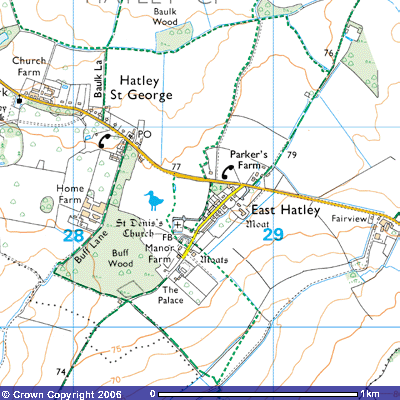
![]() Footpath 16 starts
at about 76 metres above sea level on east side of East Hatley village street,
before you get to Manor Farm and The Palace (TL 286504). According to the
Victoria County History of West Cambridgeshire, The Palace is ’a high, gaunt
house erected for members of Downing College to occupy while supervising the
College estate (P.R.O., RG 10/1577; Cambs.
Ind. Press, 1st Dec. 1961). The parish had fallen into such a
poor agricultural state in the early 19th century that the College
began investing. They had acquired Sir George Downing’s estate in 1800 (see Gamlingay Footpath 8 for details of the Downing
story). Small cottages began to be built on the village street in the 1850s and
there were six farms by the 1870s. The college bursar is said to have moved in
to The Palace as the estate manager.
Footpath 16 starts
at about 76 metres above sea level on east side of East Hatley village street,
before you get to Manor Farm and The Palace (TL 286504). According to the
Victoria County History of West Cambridgeshire, The Palace is ’a high, gaunt
house erected for members of Downing College to occupy while supervising the
College estate (P.R.O., RG 10/1577; Cambs.
Ind. Press, 1st Dec. 1961). The parish had fallen into such a
poor agricultural state in the early 19th century that the College
began investing. They had acquired Sir George Downing’s estate in 1800 (see Gamlingay Footpath 8 for details of the Downing
story). Small cottages began to be built on the village street in the 1850s and
there were six farms by the 1870s. The college bursar is said to have moved in
to The Palace as the estate manager.
The Moats marked on the O.S. map and other earthworks in the vicinity
of the footpath are referred to in the Royal Commission of Historic Monuments:
(15) MOATED SITE (Class A1
(a); N.G. TL 285503), immediately N.E. of The Palace on the S.E. side of East
Hatley village street. From the interior of the moat, now a kitchen garden,
pottery of the 13th to 18th centuries has been collected.
A trapezoidal area 160 ft. N.W. by 125 ft. N.E. by 164 ft. S.E. by 150 ft. S.W.
is surrounded by a wet ditch 20 ft. to 30 ft. wide and 2 ft. to 2 ½ ft. deep.
There is a causeway, perhaps original, 20 ft. wide, in the centre of the N.W.
side, the ditch of which is doubled near the N. angle.
…S.E. of the green are other ditched
enclosures. That furthest to the N.E., 230 ft. N.E. to S.W. by 90 ft. with ditches 15 ft. to 20 ft. wide
and 1 ft. to 2 ft. deep, is cut by the modern road. Immediately S.W. of this
are remains of five or more similar enclosures, approximately 100 ft. to 120
ft. square. S.E. of these, adjoining ridge and furrow, cobbles and pottery of
the 11th to 17th centuries occur; more irregular remains
to the S.W. are probably further building sites. Kinks in the hedge parallel to
the S.E. side of the green suggest long crofts behind the ditched building
enclosures, later destroyed and ploughed or reploughed into the existing
fields.
(R.C.H.M. (1968), Inventory Vol. I, West
Cambs. p. 150)
After about 300 metres it crosses a footbridge across
a drainage ditch (TL 288503) and begins to descend the valley in a
south-easterly direction. The village used to have sixty acres of meadow along
this water-course, thought to have been separated by two double rows of
furlongs, 220 yard long strips. The NW- SE rectangular shape of the fields to
the south and east of East Hatley mostly lie across the length of the medieval
furlongs, 220 yard long strips behind the small crofts, farms that used to line
the south-eastern side of the triangular village green. About 450 m. further
down before the bottom of the valley it crosses another footbridge (TL 289501)
at 61 metres above sea level and then turns south-southwest and follows the
north-western side of the valley for about 400 m. to meet Bridleway 14 at the bridge over the stream (TL
287497). Bridleway 14 takes you northwest back up the hill towards Bridleway 3
and Buff Wood or southeast towards Hart’s Old Farm and Croydon.