Footpath 16 (Sandy)
Direction W-E, then S-N,
Distance c.400m.
![]()
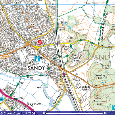 Footpath 16 is part of the
Greensand Ridge Walk where it passes through the east of Sandy. It starts about
50 metres up St Swithun’s Way, the road opposite the Fire Station. Turn first
right into Stone Croft (TL 177491) where you should see a signpost with a
muntjac (small deer) on it indicating the Greensand Ridge Walk.
Footpath 16 is part of the
Greensand Ridge Walk where it passes through the east of Sandy. It starts about
50 metres up St Swithun’s Way, the road opposite the Fire Station. Turn first
right into Stone Croft (TL 177491) where you should see a signpost with a
muntjac (small deer) on it indicating the Greensand Ridge Walk.
At
the end of the hedge turn left and you should see a signpost indicating a path
between the back gardens of the houses that takes you to the footbridge over
the main railway line. Footpath 16 follows a trackway to the north which, after
about 300m, takes you to Cambridge Road and the road bridge over the railway
(TL176493). The Greensand Ridge Walk goes over the footbridge onto a track
running above the top of the railway cutting. In front you can see across the
field to the woods surrounding Caesar’s Camp. This is Footpath
15 which takes you up to the top of Clon Hill. The track to the north,
takes you through the trees and up a steep bank of about 150 metres to a
viewpoint and a bench. The views over Sandy and the Ivel valley are worth
seeing.