Footpath
1
Direction
Roughly E – W Distance: 1,200m.
![]()
![]()
![]()
![]()
![]()
![]()
 Footpath 1 is part of an ancient farm track
and pathway that ran roughly east to west from the farming villages near Little
Gransden, along the northern part of Gamlingay, to the River Ivel at Tempsford
and the Great Ouse at St Neots. It allowed tenant farmers and agricultural
labourers access to what was in medieval times the ridges and furrows on East
Field. Underlying it is mostly the well-drained soils of the Cambridge
Greensand with alluvium, silt river deposits, on either side of Millbridge
Brook.
Footpath 1 is part of an ancient farm track
and pathway that ran roughly east to west from the farming villages near Little
Gransden, along the northern part of Gamlingay, to the River Ivel at Tempsford
and the Great Ouse at St Neots. It allowed tenant farmers and agricultural
labourers access to what was in medieval times the ridges and furrows on East
Field. Underlying it is mostly the well-drained soils of the Cambridge
Greensand with alluvium, silt river deposits, on either side of Millbridge
Brook.
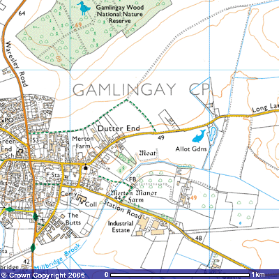
The footpath starts where
Church Street, the road running NE out of Gamlingay towards Little Gransden,
becomes Long Lane (237525). A signpost indicates a grassy field track running
NW towards Gamlingay Wood. The OS map records it as being 53 metres above sea
level. This part of the village is known as Dutter End, the most picturesque
part of the village, presenting the walker with a view of many 17th and 18th
century houses, some of them thatched.
Who or what was Dutter? It
could be a variation of the Saxon word dotter – meaning daughter. A daughter
settlement is a term used in settlement studies to indicate a new group of
farmsteads within walking distance of the original. As archaeological evidence
shows a Saxon village on the eastern bank of Millbridge Brook about 700 m to
the south, Dutter End could have originally been a smaller community on the
northern bank. The Great Fire of Gamlingay in 1600 swept right through Dutter
End and along Church Street causing much devastation. Evidence of the
rebuilding in the early 1600s can still be seen today with many fine,
timber-framed buildings in Dutter End, including three former public houses,
one of which has an original brew-house, now converted to a garage. The Old
Bull is now brick cased, and Jessamine Cottage has a date panel of 1673 at the
base of its brick chimney-stack. A "Dolls House" cottage is tucked
away in a gap.
Before you start the walk
look south over the road. Archaeological finds in this area show Gamlingay has
had man thousands of years of human occupation. Palaeolithic (500,000 BC to
10,001 BC) stone borers, gravers and scrapers of the Aurignacian and
Magdalenian periods, together with six finely worked pigmy implements were
found in this locality (SMR 2386) ,as well as an early Mesolithic to late
Bronze Age (10,000 BC to 2201 BC) axe head and arrowheads. Our prehistoric
hunting and gathering ancestors moved around this valley (SMR 8353, 2006;
TL244452551).
Across the field you may be
able to identify the sunken features of a medieval moat (TL246525). In it were
found a Mesolithic axe, flint core, scraper, microlith, ten blades and flint
flakes (SMR 2336 TL24455). In the strip of land between the allotments and the
brook were found two core tools, seven scrapers, 3 microliths (tiny flint
chppings) and a flint knife blade. (SMR 8267; TL248524). Analysis of aerial
photographs revealed several pits inside a large, rectangular, ditched
enclosure which have been suggested as an Iron Age or Roman settlement.
Ploughing upturned a variety of flint implements from Mesolithic to Bronze Age
times, and five axes dated to Mesolithic times. (SMR 11980) Whilst it has been
suggested to be the site of a Roman villa the Cambridgeshire Archaeology
Department’s Site and Monument Record suggests the buildings may have been
associated with Avenells manor.
There was an evaluation done
on the site in 1996 which revealed a Saxon cemetery (600 – 1000 AD) with
skeletons of both males and females. The graves were aligned east to west
indicating a Christian village. Ditches were examined which dated to the
prehistoric and Saxon periods and indicate enclosures. Droveways (farm animal
trackways), postholes, pits, sunken grubenhauser (sod houses) and a long
building were identified. Large pottery items were found, probably made using
the local clay (SMR 11980A TL243519). Much more detail about the Saxon
settlement can be found in the history section on the Gamlingay Village website.
When this area was settled by the Angles and later the Saxons, the long, largely rectangular parish was established. The name ‘Gamlingay’ is thought to be derived from the Anglo-Saxon words ‘ingas’ meaning a group of people and ‘ay’ meaning island so some local historians suggest this area was an island of Gamel’s or Gamela’s people. Gamling is said to be a Norse word for “old men” so it is possible a small community settled, here. Gamel, or someone with a similar sounding name, could have been the Saxon landowner who was given this land in return for fighting for the king during the Saxon’s occupation of East Anglia.
It was the Saxon custom for rectangular landholdings to include a wide variety of soils for the villagers to farm. Gamlingay parish is the largest in West Cambridgeshire stretching about 8.7 kilometres (5 miles) east to west and about 3.2 km. (2 miles) north to south at its widest. The soils ranged from the heavy, poorly drained Oxford clay east of the Roman Road in the valley of the Great Ouse to the west to the light, sandy soils on the top of the Greensand Ridge. In those days much of this land was wooded with clearings made for small farmsteads. The thinner soils on the ridge top had fewer trees but were poorly drained as a result of an iron pan. This was a hard rock stratum just below the surface where iron, leached out of the greensand, crystallised out at the top of the water table. This resulted in extensive heath land dominated by gorse, bracken, bramble and briars and two quaking, acidic bogs. One was on Gamlingay Heath and the other at Gamlingay Cinques.
As you descended the gentle slope eastwards down towards the village, the soils were still poorly drained but more loamy, a mixture of sand and clay. Further east there was the ‘thin, cold and hungry’ Oxford clay. Alongside the small streams that drain the area is alluvium soil, a river-deposited silt that, containing more nutrients, was quite fertile. To the south of the parish is a bed of gravel, deposited during one of the last ice ages which had removed most of the Upper and Lower Cambridgeshire Greensand.
This range of soils allowed Gamela’s people to grow cereals and vegetables, keep pigs, chickens, horses, cattle, sheep, hunt for deer, wild pigs, birds and rabbits, collect berries, fruit, nuts, mushrooms, eggs and firewood. The only thing missing was fish, hence the later construction of moats and ponds.
The Viking invasions of East
Anglia in the 9th century following their defeat of King Edmund’s
forces in 870, gave Ingvar control of this area. He was one of the leading
Danish warriors who ordered Edmund’s beheading when he refused to give up his
Christian faith. The Viking King probably rewarded him with land and it could
well have been one of his descendants, also called Ingvar who was a landowner
in ‘Gamlingei’ in the 11th century.
The Victoria County
History of Cambridgeshire gives a detailed account of the changes in land
ownership following the Norman invasion of 1066. According to the Domesday Book
of 1086, Ingvar and Wulfmer of Eaton (Socon) had their lands in Gamlingei
confiscated by Eudo Fitzhubert and Ranulph, brother of Ilger. The new King
William rewarded his supporters by giving them land. Part of Eudo’s estate
included nine hides (441 hectares or 1,080 acres) which Earl Alric or Aylric, a
powerful Huntingdonshire nobleman, had given to the monks looking after the
relics of St Neot in a priory in Eynesbury. They had been brought from Cornwall
in 974. The bishop of Ely appointed the abbot of the priory, but, when the
Normans put Benedictine monks from Normandy in charge, a Lisois of Moutiers
appropriated land in Gamlingay which is thought to have become Gamlingay Park.
Following the Norman
Conquest, the Saxon landowners had their properties confiscated and rewarded to
the supporters of the king. It was common for them to build manor houses where
they, their family and servants would live. Many had a moat round them, not
necessarily for defensive purposes, but for decoration and as fish ponds. Being
Roman Catholic, the villagers fasted every Friday and during the forty days of
Lent by not eating meat. When the land in this part of Gamlingay was awarded to
the Avenells is uncertain. The earliest reference to them is 1180. Their
details can be found by clicking on this link: Avenell
family. The northern side of the moat, round what is thought to be
Avenell’s manor, was Millbridge Brook. It’s probable that ditches were dug so
the brook drained round the other three sides. The south ditch was 414 feet
(153.1m.) long, the east 229 feet (84.73m) and the west 225 feet (83.25m.).
On the island inside the
moat used to stand the medieval manor house but it was burnt down in the Great Fire of Gamlingay in 1600 (SMR 1140
TL24585235). It was then in the possession of Merton College, Oxford, who
purchased the estate the previous year. The land, including the park and the
manor house site, reverted to farming and much of the area was ploughed over
and the moat filled in.
The large fields east of
Merton Farm were marked on the 1601 map as Berrie Close and Greate Broome
Close at Berrie Ware. Today they
are planted with oil seed rape. In the Middle Ages it was the
south-western corner of what was called East Fielde. Aerial photographs
have revealed a medieval field system in the fields further up the slope to the
east with extensive ridges and furrows (SMR 11399).
The footpath was a medieval
farm track, marked on the 1601 map as Burgey dele balke . As you follow
it 400 metres the north, the field to the west was called Avenelles Walnut Tree Close. You rise
gently to meet an old farm track at about 54 m. asl (TL244527). This follows
the SE facing slope of the valley NE towards Fuller’s Hill Farm. It is now a permitted path to Gamlingay Wood, kindly
provided by Merton College. In medieval times this track was known as Snake
Hill, probably after grass snakes. The fields to the northwest
were owned by Abr. Jacob Jo. Burgoyne Esqr. Sometimes the Abbot of
Saltry (Sawtry) and Avenelles.
Footpath 1 however turns
back SW along the farm track for about 200 m. until you meet the fences or
hedges marking the northern boundaries of the properties on Church Street.
These replaced those destroyed during the Great Fire of Gamlingay in 1600. You
will catch glimpses of the rear of the buildings that were built afterwards.
Amongst them you can see Merton Manor Farm.
About 450 m. ahead is the
post-second World War housing estates of Avenells Way, Gray’s Road, Manor Road
and Murfitt’s Road. The footpath ends 150 m. west where Gray’s Road meets
Waresley Road (TL246525). On the 1601 map it showed the land to the south was
owned by Ro. Russell gent. and the
strip of land to the north by Mr Jacob. It was Mrs Jacob who had the almshouses
built on Church Street. On the opposite side of the road is a triangle of open
ground, formerly known as Spittle Pitte.
Cinques Road was formerly called St Neots
Waye.