Bridleway 10 Hatley St George
Direction N – S; Distance
c.2,400 m. Back to map
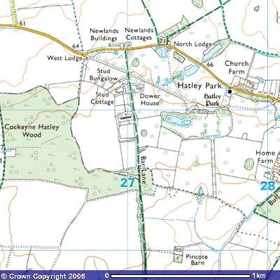 This
bridleway starts on the south side of the Hatley Road in Hatley St George,
opposite Newlands Buildings (269514). At 70 metres above sea level you have
commanding views to the north towards Little Gransden and west towards St
Neots. The signpost on the northern
side of the road says Cockayne Hatley 2½ and Tadlow 3 miles.
This
bridleway starts on the south side of the Hatley Road in Hatley St George,
opposite Newlands Buildings (269514). At 70 metres above sea level you have
commanding views to the north towards Little Gransden and west towards St
Neots. The signpost on the northern
side of the road says Cockayne Hatley 2½ and Tadlow 3 miles.
Once through the field gate you enter
Hatley Park. Hatley is said to come from the Old English word Hattenleia,
which may mean Hætta's wood or clearing. Who or what Hætta was is unknown.
Maybe it was the name of the hill or, more likely, the name of the family that
first cleared the trees to make a settlement. It was a good site on the flat
land on top of the Cambridgeshire Greensand
overlooking the valley of the River Rhee to the south and the gentle
rolling land to the north. There are numerous springs nearby where fresh water
could be found.
It has been suggested that the original
settlement of the Hatleys developed close to the line of an ancient route which
ran from the fens north of St Ives through Eltisley to Baldock (Herts.). This
bridleway survives as part of this routeway, known as Bar or Burr Lane
(R.C.H.M. Cambs. Vol. I p.145). In
the Victoria County History of Cambridgeshire it pointed out that
it may be significant that in 1279 the villains of Hatley St George were said to owe an annual carrying-service to St Ives (Rot. Hund. (Rec. Com.) Vol. 2, p.539). Park Farm, perhaps the original site of the manor house of the St Georges, stands near Bar Lane (R.C.H.M. Cambs. Vol. I p.148-9). The ways to Cambridge and Royston were mentioned in 1639. The Royston way may have followed the course of the modern road, but the Cambridge way perhaps ran north-eastwards across the parish to join the Cambridge way in Longstowe and continue on to the county town as Port Way. (C.U.L. Ely Dioc. Recs. H1/3). A drift way running north-eastwards went out of use after 1839, and the principal drives to Hatley Park were made after 1841 (C.R.O. P88/27).
(V.C.H.
Cambs, i, p. )
Who the Saxon landowners of
Hatley were is unknown. The Domesday Book of 1086
refers to a Robert, son of Wymarc. Wymark was a Breton name, `we o march,' meaning ‘worthy of a horse’. Brittany was then independent of France and those Breton
mercenaries who accompanied William, Duke of Normandy in his conquest of
England, were given land in return for their assistance. The Saxon’s land in
this parish was confiscated and given to Count
Alain, Eudo, son of Hubert, and Picot of Cambridge. They then rented the fields
out to the ‘paysans’, country people, from which we get the English word
peasants.
LAND OF COUNT ALAIN
In LONGSTOW Hundred
In HATELAI
Ælmer holds 1 virgate from the Count. Land for 2 oxen. The value is and always
was 2s 4d.
LAND OF EUDO SON OF HUBERT
In LONGSTOW Hundred
In HATELAI
Eudo holds 1 hide. Land for 1 plough; but it is not recorded there. In lordship
3 virgates and 10 acres, with 3 smallholders with 20 acres. Wood for fences.
Value 5s; when acquired 10s; before 1066, 20s.2 Freemen of Robert son of Wymarc
held this land and could sell.
LAND OF PICOT OF CAMBRIDGE
In LONGSTOW Hundred
In HATELAI
Roger holds 2 hides from Picot. Land for 2 ploughs. In lordship 1; 4
smallholders with 6 cottagers and 1 villager have ¼ plough; [another] ¼
possible. Wood for fences and houses. Value 20s; when acquired 60s; before
1066, 100s. lfward, Robert son of Wymarc's man, held this land and could sell.
In the same
village Picot holds 1 hide. Land for 1 plough; ¼ plough there; [another] ¼
possible. Wood for fences and houses. 3 villagers. Value 10s; when acquired
20s; before 1066, 40s.
3 Freemen of King Edward's held this land; they found 1 cartage for the
Sheriff.
Picot states he had this is exchange for Rushden, which Sigar holds. [Sigar of
Chocques, but this exchange is not mentioned there.]
NAMES OF JURORS
In LONGSTOW
Hundred swore
·
William,
Picot the Sheriff's man
·
Tihel,
the Abbot of Ely's reeve
·
Warin
the priest
·
Guy,
the Abbot of Ramsey's man
·
Godric
od Croxton
·
Ælfric,
Eudo's reeve
·
Wulfwy
of Hatley
·
Young
Ælmer
During the reign of King Henry III (1207 – 72) land in Hatley was awarded to St George. A James of St George, Savoy, who died in 1308 was a military architect. From 1278 he was responsible for designing King Edward I’s castles in Scotland and Wales. They included Conwy, Caernarfon, Harlech, Beaumaris, Flint and Rhuddlan. He probably lived in a fine manor house on the estate.
On Thomas Langdon’s map of Gamlingay in
1601 the Bridleway was marked as a continuation of Seaslade, Porte Deane or
Hatley Deane, a trackway which
ran north to south through Southe Fielde
from Pightle Greene, the meadow on
both sides of what became known as Millbridge Brook. The fields on the west
were called Awsten’s Land. It crossed Hatley Waye and continued south an a track called Shovell broade or sheep
broade, indicating the land’s agricultural use.The field to the east called Prestons
graice furl(ong) was
divided into the long strips commonly termed ridge and furrow. It crossed Narrow
waye or sheep broade which ran to the southeast and continued to the county
boundary. The land to the southwest was marked as Parte of Stocking in
Hatley Parte, the land to the southeast as Parte of Porche in Hatley Porte to the west. On
other maps this latter area was called Hungrye
Hatleye.
It was stated that the Hall at Hatley St George was built in 1640 for Sir Henry St George on the site of Park Farm (TL281506). John Layer (d.1640) wrote that the ‘ancient seat is decayed, a fine site of an old house, and a pretty gentlemanlike seat now there built’ (John Layer C.A.S. 8vo ser.liii, 106). The early 17th century building appears to have formed the nucleus of the present manor house called Hatley Park standing south-east of Park Farm. According to the Royal Commission of Historic Monuments
PARK FARM, 80 yds. E. of Bar Lane, L-shaped, two-storeyed, framed,
with tiled roof, though considerably altered and with modern infilling in the
angle, is probably of 16th century origin; it may have been the
house of the manor of the St George family, the seat of which was transferred
to its present site c. 1635.
The
main N. and S. range has been cased in modern brick and has two added window
bays on the E. side and one at either end. The W. part of the long E. and W.
wing, which is plastered, was originally lower than the rest and open to the
roof, but has been heightened. Over the rest of the house the roof, largely
original though of rough construction, is based on tie-beam and collar trusses;
two plain cambered tie beams are partly exposed in the E. part of the wing.
The S. ground-floor room of the main range is lined with 17th
century run-through paneling, for the most part in situ, including a length of
frieze with incised fan ornament; from the arrangement of the paneling a door
in the centre of the N. wall of the room and another opening in the S. wall can
be inferred. This room has a chamfered brick fireplace surround with segmental
head, also 17th century.
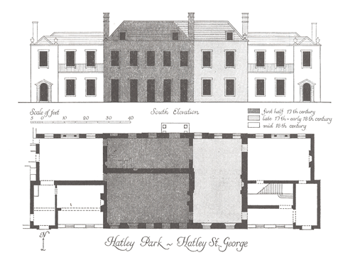
SECULAR
HATLEY
PARK, house with service buildings and grounds, stand on upland sloping gently
N. to Millbridge Brook.
The House,
two-storeyed, partly with cellars and attics, of local red brick (from
Gamlingay brickworks?) with roofs of Westmorland and other slate, is the
product of at least three building phases, not counting changes within the last
hundred years. Though predominantly an 18th century structure it
incorporates a 17th century nucleus John Layer in his History of
Cambridgeshire (C.A.S. 8vo. Publs. Liii, (1933), 106) remarks ‘the ancient seat
is decaied and a pretty gentlemanlike seate now there built’. Attached to the
1601 maps of Gamlingay, by T. Langdon, at Merton College, Oxford, is a
comparatively crudely drawn supplement showing the W. part of Hatley and
depicting ‘Mr St Georg his house’ apparently in the position of Park Farm
(Monument (4)). Layer’s words imply
recent rebuilding on a fresh site and this is most likely to have been
done by Sir Henry St George, garter King of Arms, between his father’s death in
1635 and Layer’s own demise in January 1641. an engraving by Johannes Kip
(Britannia Illustrata (1707), Plate 58) purports to show the house as it was
after a rebuilding attributed to the Lysons
(Cambridgeshire, 210) to Sir Robert Cotton (of the Connington Cottons),
who came into the property while still a minor (under 21), perhaps as early as
1682 (See PARISH CHURCH OF ST GEORGE, Monument (2), Bells). After Sir Robert
Cotton’s death in 1749 the property passed by a series of marriages to Margaret
Cotton (of the Madingley family); she had already enlarged the house by 1753
(E. Carter, Cambridgeshire, (1753), 199), adding wings on either side of the
house as left by her predecessor, although the wings as they now stand may not
have been completed until after that date. During the second half of the
century the house belonged to the Pearse family; a Mr. Pearse was offering the
materials of the house for sale in 1782 (Cambridge Chronicle, 16 Nov. 1782); it
was purchased by Thomas Quintin but was not demolished, although it may have
then been stripped of its fittings. The Quintins may have refaced part or all
of the N. front.
The
house was again enlarged and lavishly refitted in reproduction Georgian style
late in the 19th or early in the present century. Some genuine 18th-century
chimney pieces and other embellishments have also been imported within the last
hundred years. Modern additions at the E. and W. ends have recently been
demolished (pre-1977).
The N.
or principal elevation is in thirteen bays with late 18th or 19th-century
sash windows on both floors; seven bays are those of the middle block, being
Sir Robert Cotton’s house of c. 1700; the remaining six, three and three, are
those of the wings added c. 1750. The uniformity of the brickwork may be
attributable to re-facing of the middle block about the time that the wings
were added. The middle block consists of a three-bay centre piece and side
pieces of two bays each and has a stone cornice and parapet with stone coping
(slanted bricks to all rain run-off); this parapet is broken by a central
pediment framing a small round window. The quoins of the centre and side
pieces, as well as those of the wings, are of rusticated stone; the front is
embellished with six stone urns. The central front door is modern, the
Palladian windows in the middle of the ground floor of the wings are 18th
century but appear to have been improved.
The S.
elevation is irregular, owing to the incorporation of the original 17th
century house. This is reflected by five closely spaced bays occupying most of
the middle block, which are supplemented by two bays towards its east end;
these and the uniform red-brick facing of the middle block on this side are of
c. 1700. For the rest, the elevation is symmetrical, with a stone-capped
parapet extending its entire length surmounted by six stone urns. The side
pieces, apparently a somewhat later elaboration of the mid 18th
century wings of the N. front, were at first built with two bays, each deeply
recesses, and the third, at the ends, breaking forward again as turriform
projections (in the shape of turrets); but the effect has been weakened by
modern ground-floor infilling with flat roof and cast-iron balustrade, the last
perhaps reused. All the windows on the S. side are late 18th or 19th-century
sashes with stucco (durable, exterior wall coating of cement, sand and lime)
surrounds except for three dormers in the centre block. Two rainwater heads of
the late 18th century survive. The glazed and pedimented (stones at
base) doors at either end are modern.
The
inside of the house has been rearranged and is almost devoid of original
features, but some paneled doors and shutters, also one or two wooden fireplace
surrounds in the attics, are old. Irregularities in the modern plaster ceiling
of the drawing rooms probably result from the removal of a through passage
bisecting the original house. The
growth of the house may also be reflected in the irregular lay-out of the
cellars. The roof of the middle block, which is hipped and rises to a central
valley, is framed with staggered purlins (horizontal timbers supporting the
rafters); its members, partly of oak and partly of softwood are of variable
scantling (upright in house frame); the oak may well be reused timber from the
roof of the original house (at Park Farm, now the Dower House).
W. of
the house predominantly modern. Service Buildings include three or four of
those illustrated by Kip, all in red brick of c.1700 but much altered. The most
considerable of these fronts to the N. and retains most of its symmetrically
disposed windows with flat arches and a central doorway with rusticated quoins
(roughly finished, unsophisticated, exterior corner stones) and head in
stuccoed brick. The Grounds include gardens on the N. bearing no relation to
those delineated by Kip; these are diversified by adventitious statuary and
urnage in marble, freestone and composition of the 17th to 19th
centuries. The large and pleasant park seems to have been created about the
middle of the 19th century.
The RCHM also includes details of numerous earthworks in the gardens:
(13) GARDEN REMAINS (mostly on O.S. at
Hatley Park (Monument 3)). The park was mostly arable until the 17th
and 18th centuries. Three features shown on some O.S. maps as
‘moats’ are remnants of a garden lay-out of that period. That to the S. of the
house (N.G. TL 27055081) is an E. and W. wet ditch 325 ft. long, 15 ft. wide
and 2 ft. deep separating the gardens from the park (possibly a ha-ha – a ditch to stop cattle
and sheep getting onto the lawns and flower beds in front of the mansion); a
causeway 15 ft. wide, revetted with 18th century brick, crosses it
on the axis of the house, a rectangular pond (N.G. TL 27555094), has been
destroyed. The third, E. of the house, is merely a curving N.W. and S.W. ditch,
12 ft. wide and 1 ½ ft. deep, with a bank 15 ft. wide and 2 ½ ft. high within
it.
Other earthworks in the park do not appear on the tithe map of 1839 and were presumably made after that date. The most prominent are a bank along the S. side of the road, 600 ft. long, 25 to 40 ft. wide and 2 ft. to 4 ft. high (possibly a ha-ha), and an irregular mound (N.G. TL 27315140) 90 ft. across and 3 ft. high...
(20)
CULTIVATION REMAINS in the former parish of Hatley St. George (not on O.S.).
Ridge and furrow survives over much of the former parish, especially in the
park. The remains are mostly curved with ridges 100 yds to 270 yds. long, 5
yds. to 13 yds. wide and 1 ft. to 1 ½ ft. high with headlands of 7 yds. to 12
yds.
Around N.G. TL 276507
ridge and furrow running N.E. and S.W. is bounded by a winding hollow-way 40
ft. wide, 1 ft. to 3 ft. deep and 25 ft. across the bottom, perhaps an old
route to Tadlow. To the E. of this are three small blocks of ridge and furrow
running N. to S. with an access way, 30 ft. wide and 9 ins. deep, running E.
from the main hollow-way for 80 yds. between the two blocks further N. Traces
on air photographs complement these remains and much of the former open-field
pattern can be seen, with field boundaries fitting curving furlongs. The parish
was probably enclosed by the 17th century. (Ref: tithe map 1839
(T.R.C.); air photographs: 1060/UK/1635/1465-8; CPE/UK/2024/3020, 3060-3)
(R.C.H.M. Cambs. i, 148-9, 151).
St George’s descendants owned most of Hatley until the English Civil War which broke out in 1642. John St George supported the Royalists, as did his neighbour, Robert Castell of East Hetley. Following the defeat of Charles I, Parliament fined them both. In 1658 Richard St George was forced to sell the manor to the wealthy Sir Thomas Cotton of Madingley, near Cambridge, who altered the house out of all recognition. Follow the link for details of the Cotton Family tree.
When Sir Thomas Cotton died in 1662 the estate passed to Sir John Cotton, who owned Landwade Hall, Cambs. He had been knighted in 1641 for ‘spiriting away some college plate from Cambridge’ and giving it to King Charles I at Oxford. He died in 1689 and the following year it passed to his half-brother Sir Robert Cotton. Between 1662 and 1674 the mansion was extensively rebuilt by Sir Robert (E179/84/436; E179/244/13) and there were further additions until 1715.
It was contemporary with the construction of Everton House by Mr Astell, a director of the East India Company, Gamlingay Park built by Sir George Downing and Tetworth Hall by John Pedley, the MP for Huntingdonshire. This was a time when wealthy merchants and politicians were building fine country mansions and developing parklands in which to escape the city life with its noise, dirt, disease and pollution and entertain their guests in style.
Sir
Robert Cotton’s daughter, Alice, inherited the hall on her father’s death. She
married Robert Trefusis in 1702. On her death, Robert married Margaret (d. 1734)
who also enlarged the house
(Carter, Hist. Cambs. 199-200). Following
Robert Trefusis’ death, Margaret married Sir John Hinde Cotton (d.1752). Alice’s son Robert Trefusis sold the house
to Commissioner Pearse in 1732. His son, Best Pearse (d.1796), sold it in 1882
to Thomas Quinton, a wealthy glass manufacturer. In 1806 it was in the
possession of John Whitby St Quentin (Lyson’s Cambs. 1808). Thomas St Quentin owned it in 1833 and he sold it in
1875 to Alexander McKenzie (Kelly’s Directory 1868). By 1883 it was in the
possession of John Carbery Evans, Justice of the Peace. In 1896 it was owned by
Ernest Terah Hooley, a financier and fraudster with a colourful history.
Hatley Park comprised 115a. in 1868, but
had been enlarged by 1895 to 256a. including pleasure grounds and plantations.
It was intended as a small scale sporting estate (C.U.L. Maps 53(1)/95/11), In 1905 work on the
estate was provided to avoid unemployment (E.D.R. (1905),12). In 1916
it was occupied by Lieutenant Colonel Sir Charles Edward Hamilton DL, JP.
Between 1922 and 1929 it was lived in by Ernest Ridgill.
According to the Kelly’s Post Office
Directory of 1929 "Hatley Park is the seat of Ernest Ridgill esq. who
is lord of the manor and the principal landowner; the mansion is of brick with
stone dressings in the Italian style of the early 18th century, and stands in a
well-wooded park of 300 acres. The soil is clay subsoil, boulder clay. The
chief crops are wheat, oats and barley. The area is 1,011 acres of laud and
inland water; the population in 1921 was 67."
Between
1935 and 1937 it was occupied by Herman Andrew Harris Lebus, CBE, JP, a furniture manufacturer from London. During
the Second World War it was occupied by the military and one of the men
stationed there, John Jacob Astor, bought the estate in 1947. He was the
youngest son of Lady Astor, the first female MP, and developed the estate for
his race horses, building a stud farm. His horses were trained along the
gallop, a several mile run along the northern bank of Millbridge Brook, which
ran parallel to the Cambridge to Bedford Railway. In 1961 it was said that most of the
inhabitants were employed on the estate, which included Major Astor’s stud farm
(Cambs. Chron. 1 Dec. 1961). Astor
was knighted in 1978.
Hatley
Park is now in the possession of his son, Michael Astor. The additions made to
the house in the late 19th
and early 20th century were demolished in the 1960s (R.C.H.M. Cambs. i,149; Notes by Ishbel
Beatty, East Hatley)
Walking through the park you can now better
understand its history. When you cross the cattle grid, an avenue leads
southeast towards Hatley Park house. Carrying on south you pass through the
remains of the early formal gardens, described as about 1.5 hectares of
pleasure grounds and about 130 hectares of landscaped park.
You pass some of the estate buildings, Stud
Bungalow, Stud Cottage and the Dower House (TL 271512). This house used to be
called Park Farm, thought to have been the site of the original manor house of
the St George family. Bar Lane
continues south for about 500 metres past more stables and paddocks
until it crosses the European Constituency & County Constituency Boundary
(TL271505) into Bedfordshire. It then continues south as Bridleway 1.
Other Hatley stories:
The History of Hatley
St George in Victoria County History
The History of East Hatley
in Victoria County History
The Royal Commission of
Historic Monuments account of East Hatley
Downing
College’s 1978 pilgrimage to East Hatley
Hatley articles written by Ishbel Beatty
The Man who
lived in the Palace