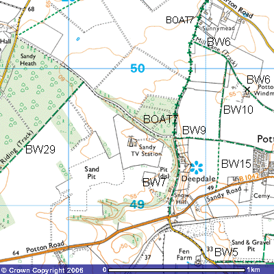
Bridleway 9
Direction E – W
Distance: c.800m.
 Bridleway
9 (Potton) is the first part of what used to be the Old Bedford Road - the
route west out of Potton that took traffic across Sandy Heath towards Sandy,
Tempsford and onto Bedford.. It starts at the corner of New Town and Mill Lane,
Potton and travels out of town past the new housing estate to the south that
was built on an old market garden and town recreation ground. For a further 300
metres it crosses flat, well-drained sandy, market gardening country towards
Deepdale. To the north you can see the remains of Potton Windmill.
Bridleway
9 (Potton) is the first part of what used to be the Old Bedford Road - the
route west out of Potton that took traffic across Sandy Heath towards Sandy,
Tempsford and onto Bedford.. It starts at the corner of New Town and Mill Lane,
Potton and travels out of town past the new housing estate to the south that
was built on an old market garden and town recreation ground. For a further 300
metres it crosses flat, well-drained sandy, market gardening country towards
Deepdale. To the north you can see the remains of Potton Windmill.
The underlying greensand
was worked extensively for coprolites – the raw material in the manufacture of
superphosphate in the second half of the 19th century. Bernard
O’Connor’s The Dinosaurs on Sandy Heath,
obtainable from the library, provides the details. A shorter version can be found on the account of the Long Riding,
Bridleway 29.
After about 400 metres there
is a crossroads (TL 201496). Bridleway 15 takes you south for about 300 metres
to Sandy Road. Bridleway 10, a continuation of Bridleway 15, takes you north
for about 600 metres to Bridleway 6 (Mill Lane). The farm track continues west
for a further 300 metres before dropping down between the two smallholdings of
Dirok and Silver Birches (208495), into Deepdale where it ends at a crossroads
(TL 207496). Deepdale was a glacial outwash channel, carved through the sand by
melting ice flowing south when the last ice sheet melted about 11,000 years
ago.
It continues northwest
along a permitted path, a
concrete road past the Sandy TV transmitter to Sandy Road, Everton. The track
to the north is BOAT7, a bridleway open to all traffic
which takes you to Everton road. The metalled road to the south is Bridleway 7 which takes you about 500m. past the Fish
Farm to the crossroads on Sandy Road.